FAA INFORMATION EFFECTIVE 20 FEBRUARY 2025
Location
| FAA Identifier: | SNP |
| Lat/Long: | 57-09-58.7000N 170-13-21.2000W
57-09.978333N 170-13.353333W
57.1663056,-170.2225556
(estimated) |
| Elevation: | 66.4 ft. / 20.2 m (surveyed) |
| Variation: | 10E (2005) |
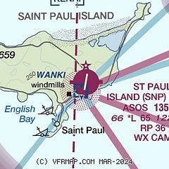
| From city: | 3 miles NE of ST PAUL ISLAND, AK |
| Time zone: | UTC -10 (UTC -9 during Daylight Saving Time) |
| Zip code: | 99660 |
Airport Operations
| Airport use: | Open to the public |
| Control tower: | no |
| ARTCC: | ANCHORAGE OCEANIC CENTER |
| FSS: | KENAI FLIGHT SERVICE STATION [907-283-7211] |
| NOTAMs facility: | SNP (NOTAM-D service available) |
| Attendance: | UNATNDD |
| Wind indicator: | yes |
| Segmented circle: | yes |
| Lights: | ACTVT MALSF RWY 18 & 36; PAPI RWY 18 & 36; HIRL RWY 18/36- CTAF. |
| Beacon: | white-green (lighted land airport)
Operates sunset to sunrise. |
Airport Communications
| CTAF: | 122.3 |
| WX ASOS: | 135.75 (907-546-2324) |
- APCH/DEP SVC PRVDD BY ANCHORAGE ARTCC ON FREQS 119.1/339.8 (SAINT PAUL ISLAND RCAG).
Nearby radio navigation aids
| NDB name | | Hdg/Dist | | Freq | | Var | | ID |
|---|
| ST PAUL ISLAND | | at field | | 314 | | 10E | | SPY | ... .--. -.-- |
Airport Services
Runway Information
Runway 18/36
| Dimensions: | 6500 x 150 ft. / 1981 x 46 m
1000 FT SAFETY AREA ON N & S END. |
| Surface: | asphalt/grooved, in good condition |
| Runway edge lights: | high intensity |
| RUNWAY 18 | | RUNWAY 36 |
| Latitude: | 57-10.503740N | | 57-09.451433N |
| Longitude: | 170-13.188613W | | 170-13.517828W |
| Elevation: | 66.2 ft. | | 39.5 ft. |
| Traffic pattern: | left | | right |
| Runway heading: | 180 magnetic, 190 true | | 000 magnetic, 010 true |
| Markings: | precision, in good condition | | precision, in good condition |
| Visual slope indicator: | 4-light PAPI on right (3.00 degrees glide path) | | 4-light PAPI on left (3.00 degrees glide path) |
| Approach lights: | MALSF: 1,400 foot medium intensity approach lighting system with sequenced flashers | | MALSF: 1,400 foot medium intensity approach lighting system with sequenced flashers |
| Touchdown point: | yes, no lights | | yes, no lights |
| Instrument approach: | MLS | | ILS |
| Obstructions: | 15 ft. road, 200 ft. from runway
15 FT ROAD 0 - 200 FT FM RWY END BOTH SIDES OF CNTRLN. | | 8 ft. fence, 460 ft. from runway, 520 ft. right of centerline, 32:1 slope to clear |
Airport Ownership and Management from official FAA records
| Ownership: | Publicly-owned |
| Owner: | ALASKA DOT&PF SOUTHCOAST REGION
PO BOX 112506
JUNEAU, AK 99811-2506
Phone 907-465-1779 |
| Manager: | DALE RUCKMAN
PO BOX 920525
DUTCH HARBOR, AK 99692
Phone 907-581-1786
OR 907-546-5000. |
Additional Remarks
| A30A-36 | THREE 100 FT WIND TURBINES 1/4 MI SW OF APCH END. 45 FT LGTD TWR 350 FT W 1000 FT N. |
| - | AVOID FLT BLW 1000 FT MAY 14 - SEP 14 IN AREAS WITH ACTIVE BIRD POPULATIONS & OTR TIMES IN AREAS WITH COASTAL SEAL ROOKERIES. |
| - | WX BLN LAUNCH FAC ON ARPT, SEE INSIDE BACK COVER FOR OPRN DETAILS. |
| - | 625 FT LGTD TWR 1 MI SW. |
| - | WX CAMERA AVBL ON INTERNET AT HTTPS://WEATHERCAMS.FAA.GOV |
Instrument Procedures
NOTE: All procedures below are presented as PDF files. If you need a reader for these files, you should download the free Adobe Reader.NOT FOR NAVIGATION. Please procure official charts for flight.
FAA instrument procedures published for use from 20 February 2025 at 0901Z to 20 March 2025 at 0900Z.
IAPs - Instrument Approach Procedures |
|---|
| ILS OR LOC RWY 36 | |
download (298KB) |
| RNAV (GPS) RWY 18 | |
download (192KB) |
| RNAV (GPS) RWY 36 | |
download (198KB) |
| LOC/DME BC RWY 18 | |
download (244KB) |
| NOTE: Special Alternate Minimums apply | |
download (61KB) |
| NOTE: Special Take-Off Minimums/Departure Procedures apply | |
download (148KB) |
Other nearby airports with instrument procedures:
PAPB - St George Airport (40 nm SE)
|
|

Road maps at:
MapQuest
Bing
Google
| Aerial photo |
|---|
WARNING: Photo may not be current or correct
 Photo taken 15-Aug-2020
looking south.
Photo taken 15-Aug-2020
looking south.
Do you have a better or more recent aerial photo of St Paul Island Airport that you would like to share? If so, please send us your photo.
|
| Sectional chart |
|---|
|
| Airport distance calculator |
|---|
|
|
| Sunrise and sunset |
|---|
|
Times for 13-Mar-2025
| | Local
(UTC-10) | | Zulu
(UTC) |
|---|
| Morning civil twilight | | 07:04 | | 17:04 |
| Sunrise | | 07:42 | | 17:42 |
| Sunset | | 19:18 | | 05:18 |
| Evening civil twilight | | 19:57 | | 05:57 |
|
| Current date and time |
|---|
| Zulu (UTC) | 13-Mar-2025 15:58:06 |
|---|
| Local (UTC-10) | 13-Mar-2025 05:58:06 |
|---|
|
| METAR |
|---|
| PASN | 131453Z AUTO 03015KT 10SM OVC019 M03/M07 A2949 RMK AO2 SLP988 T10331072 51002 TSNO $
|
|
| TAF |
|---|
| PASN | 131122Z 1312/1412 04015G25KT P6SM VCSH SCT015 OVC025 FM140600 02014G22KT P6SM SCT025 OVC035
|
|
| NOTAMs |
|---|
NOTAMs are issued by the DoD/FAA and will open in a separate window not controlled by AirNav.
|
|


