FAA INFORMATION EFFECTIVE 17 APRIL 2025
Location
| FAA Identifier: | Y50 |
| Lat/Long: | 44-02-35.2863N 089-18-20.4859W
44-02.588105N 089-18.341432W
44.0431351,-89.3056905
(estimated) |
| Elevation: | 859 ft. / 261.8 m (surveyed) |
| Variation: | 02W (2000) |
| From city: | 2 miles SW of WAUTOMA, WI |
| Time zone: | UTC -5 (UTC -6 during Standard Time) |
| Zip code: | 54982 |
Airport Operations
| Airport use: | Open to the public |
| Activation date: | 10/1947 |
| Control tower: | no |
| ARTCC: | CHICAGO CENTER |
| FSS: | GREEN BAY FLIGHT SERVICE STATION |
| NOTAMs facility: | GRB (NOTAM-D service available) |
| Attendance: | 0700-1900 |
| Wind indicator: | lighted |
| Segmented circle: | yes |
| Lights: | MIRL RWY 13/31 PRESET TO LOW SS-SR; TO INCR INTST AND ACTVT - CTAF. |
| Beacon: | white-green (lighted land airport)
Operates sunset to sunrise. |
Airport Communications
| CTAF/UNICOM: | 122.8 |
| WX AWOS-3PT: | 119.475 (920-787-0515) |
| MILWAUKEE APPROACH: | 127.0 |
| MILWAUKEE DEPARTURE: | 127.0 |
Nearby radio navigation aids
| VOR radial/distance | | VOR name | | Freq | | Var |
|---|
| OSHr274/32.5 | | OSHKOSH VORTAC | | 116.75 | | 02E |
| DLLr031/35.6 | | DELLS VORTAC | | 117.00 | | 03E |
Airport Services
| Fuel available: | 100LL
100LL:24 HR SELF SVC FUEL AVBL WITH CREDIT CARD. |
| Parking: | hangars and tiedowns |
| Airframe service: | MINOR |
| Powerplant service: | MAJOR |
| Bottled oxygen: | NONE |
| Bulk oxygen: | NONE |
Runway Information
Runway 13/31
| Dimensions: | 3300 x 60 ft. / 1006 x 18 m |
| Surface: | asphalt, in fair condition |
| Weight bearing capacity: | |
| Runway edge lights: | medium intensity |
| RUNWAY 13 | | RUNWAY 31 |
| Latitude: | 44-02.678485N | | 44-02.316797N |
| Longitude: | 089-18.549925W | | 089-17.988338W |
| Elevation: | 858.5 ft. | | 855.9 ft. |
| Traffic pattern: | left | | left |
| Runway heading: | 134 magnetic, 132 true | | 314 magnetic, 312 true |
| Markings: | nonprecision, in good condition | | nonprecision, in good condition |
| Runway end identifier lights: | no | | no |
| Touchdown point: | yes, no lights | | yes, no lights |
| Obstructions: | 88 ft. trees, 1350 ft. from runway, 350 ft. left of centerline, 13:1 slope to clear | | 67 ft. tree, 1075 ft. from runway, 275 ft. left of centerline, 13:1 slope to clear |
Runway 8/26
| Dimensions: | 2334 x 120 ft. / 711 x 37 m |
| Surface: | turf, in good condition |
| Runway edge markings: | MKD WITH WHITE HALF BARRELS. |
| Operational restrictions: | RY 08/26 CLSD WINTER MONTHS EXCEPT FOR SKI EQUIPPED ACFT. E 430 FT CLSD IN WINTER. |
| RUNWAY 8 | | RUNWAY 26 |
| Latitude: | 44-02.693827N | | 44-02.738197N |
| Longitude: | 089-18.708148W | | 089-18.179158W |
| Elevation: | 858.9 ft. | | 856.9 ft. |
| Traffic pattern: | left | | left |
| Runway heading: | 085 magnetic, 083 true | | 265 magnetic, 263 true |
| Markings: | none | | none |
| Runway end identifier lights: | no | | no |
| Touchdown point: | yes, no lights | | yes, no lights |
| Obstructions: | 60 ft. trees, 850 ft. from runway, 75 ft. right of centerline, 14:1 slope to clear | | none |
Airport Ownership and Management from official FAA records
| Ownership: | Publicly-owned |
| Owner: | CITY OF WAUTOMA
CITY HALL
WAUTOMA, WI 54982
Phone 920-787-4044 |
| Manager: | RICHARD JORGENSEN
W8471 COTTONVILLE DRIVE
WAUTOMA, WI 54982
Phone 920-787-3030 |
Additional Remarks
| - | WATERFOWL AND DEER ON AND INVOF ARPT. |
| - | ULTRALIGHT ACTIVITY ON & INVOF ARPT. |
| - | FOR CD CTC CHICAGO ARTCC AT 630-906-8921. |
Instrument Procedures
NOTE: All procedures below are presented as PDF files. If you need a reader for these files, you should download the free Adobe Reader.NOT FOR NAVIGATION. Please procure official charts for flight.
FAA instrument procedures published for use from 17 April 2025 at 0901Z to 15 May 2025 at 0900z.
IAPs - Instrument Approach Procedures |
|---|
| RNAV (GPS) RWY 13 | |
download (189KB) |
| RNAV (GPS) RWY 31 | |
download (191KB) |
| NOTE: Special Alternate Minimums apply | |
download (49KB) |
| NOTE: Special Take-Off Minimums/Departure Procedures apply | |
download (484KB) |
Other nearby airports with instrument procedures:
KPCZ - Waupaca Municipal Airport (21 nm NE)
63C - Adams County Airport-Legion Field (21 nm W)
KISW - Alexander Field South Wood County Airport (30 nm NW)
C47 - Portage Municipal Airport (30 nm S)
KSTE - Stevens Point Municipal Airport (32 nm N)
|
|

Road maps at:
MapQuest
Bing
Google
| Aerial photo |
|---|
WARNING: Photo may not be current or correct

Do you have a better or more recent aerial photo of Wautoma Municipal Airport that you would like to share? If so, please send us your photo.
|
| Sectional chart |
|---|
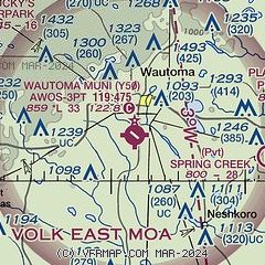
|
| Airport distance calculator |
|---|
|
|
| Sunrise and sunset |
|---|
|
Times for 21-Apr-2025
| | Local
(UTC-5) | | Zulu
(UTC) |
|---|
| Morning civil twilight | | 05:34 | | 10:34 |
| Sunrise | | 06:05 | | 11:05 |
| Sunset | | 19:47 | | 00:47 |
| Evening civil twilight | | 20:18 | | 01:18 |
|
| Current date and time |
|---|
| Zulu (UTC) | 21-Apr-2025 10:10:00 |
|---|
| Local (UTC-5) | 21-Apr-2025 05:10:00 |
|---|
|
| METAR |
|---|
| KY50 | 210956Z AUTO 04006KT 10SM OVC008 07/06 A2955 RMK AO2 RAE14 SLP011 P0000 T00720061 $
|
|
| TAF |
|---|
KATW
36nm E | 210747Z 2108/2206 11012G20KT 4SM -RA OVC020 WS020/15050KT PROB30 2108/2110 -TSRA OVC012CB FM211000 11013G23KT 5SM -SHRA OVC008 WS020/19035KT FM211400 18012G19KT 3SM -SHRA BR OVC004 WS020/18040KT FM211600 23015G25KT P6SM -SHRA OVC006 FM211700 27016G31KT P6SM OVC013 FM212200 29014G22KT P6SM SCT035
|
|
| NOTAMs |
|---|
NOTAMs are issued by the DoD/FAA and will open in a separate window not controlled by AirNav.
|
|


