FAA INFORMATION EFFECTIVE 17 APRIL 2025
Location
| FAA Identifier: | 02C |
| Lat/Long: | 43-05-22.7089N 088-10-46.0029W
43-05.378482N 088-10.766715W
43.0896414,-88.1794453
(estimated) |
| Elevation: | 844.2 ft. / 257.3 m (surveyed) |
| From city: | 3 miles E of BROOKFIELD, WI |
| Time zone: | UTC -5 (UTC -6 during Standard Time) |
| Zip code: | 53072 |
Airport Operations
| Airport use: | Open to the public |
| Activation date: | 05/1948 |
| Control tower: | no |
| ARTCC: | CHICAGO CENTER |
| FSS: | GREEN BAY FLIGHT SERVICE STATION |
| NOTAMs facility: | GRB (NOTAM-D service available) |
| Attendance: | APR-OCT 0800-DUSK, NOV-MAR 0800-1800 |
| Pattern altitude: | 1644.2 ft. MSL |
| Wind indicator: | lighted |
| Segmented circle: | yes |
| Lights: | ACTVT MIRL RWY 03/21 - CTAF. |
| Beacon: | white-green (lighted land airport)
Operates sunset to sunrise. |
Airport Communications
| CTAF/UNICOM: | 122.7 |
| WX AWOS-3 at UES (4 nm SW): | 118.875 (262-521-5226) |
| WX AWOS-3 at MWC (6 nm E): | PHONE 414-461-2954 |
| WX ASOS at MKE (15 nm SE): | 126.4 (414-400-9402) |
| WX AWOS-3PT at 57C (19 nm SW): | 118.125 (262-642-1845) |
Nearby radio navigation aids
| VOR radial/distance | | VOR name | | Freq | | Var |
|---|
| BAEr108/4.9 | | BADGER VOR/DME | | 116.40 | | 02E |
| BJBr188/(20.1) | | WEST BEND VOR | | 109.80 | | 01W |
| NDB name | | Hdg/Dist | | Freq | | Var | | ID |
|---|
| ROCK RIVER | | 103/24.4 | | 371 | | 01W | | RYV | .-. -.-- ...- |
Airport Services
| Fuel available: | 100LL MOGAS |
| Parking: | hangars and tiedowns |
| Airframe service: | NONE |
| Powerplant service: | NONE |
| Bottled oxygen: | NONE |
| Bulk oxygen: | NONE |
Runway Information
Runway 3/21
| Dimensions: | 2994 x 45 ft. / 913 x 14 m |
| Surface: | asphalt, in fair condition |
| Runway edge lights: | medium intensity |
| Runway edge markings: | MARKINGS FADED. |
| RUNWAY 3 | | RUNWAY 21 |
| Latitude: | 43-05.135720N | | 43-05.609672N |
| Longitude: | 088-10.829238W | | 088-10.644860W |
| Elevation: | 843.0 ft. | | 827.2 ft. |
| Traffic pattern: | left | | left |
| Runway heading: | 016 true | | 196 true |
| Displaced threshold: | 1378 ft. | | 694 ft. |
| Markings: | basic, in poor condition | | basic, in poor condition |
| Runway end identifier lights: | no | | no |
| Touchdown point: | yes, no lights | | yes, no lights |
| Obstructions: | 10 ft. brush, 200 ft. from runway, 65 ft. left of centerline, 1:1 slope to clear
10 FT BRUSH 0-200 FT FM RWY END; 120 - 60 FT L. | | 8 ft. brush, 200 ft. from runway, 50 ft. left and right of centerline, 1:1 slope to clear
10 FT BRUSH 0-200 FT FM RWY END; 50 FT L & 80 FT R. |
Runway 9/27
| Dimensions: | 3387 x 100 ft. / 1032 x 30 m |
| Surface: | turf, in fair condition |
| Runway edge markings: | MKD WITH YELLOW CONES. |
| RUNWAY 9 | | RUNWAY 27 |
| Latitude: | 43-05.406790N | | 43-05.436847N |
| Longitude: | 088-11.141105W | | 088-10.381713W |
| Elevation: | 832.4 ft. | | 826.4 ft. |
| Traffic pattern: | left | | left |
| Markings: | none | | none |
| Runway end identifier lights: | no | | no |
| Touchdown point: | yes, no lights | | yes, no lights |
| Obstructions: | 8 ft. brush, 25 ft. from runway, 25 ft. left of centerline, 3:1 slope to clear | | 82 ft. trees, 1400 ft. from runway, 17:1 slope to clear |
Runway 18/36
| Dimensions: | 1602 x 80 ft. / 488 x 24 m |
| Surface: | turf, in fair condition |
| Runway edge markings: | MKD WITH YELLOW CONES. |
| RUNWAY 18 | | RUNWAY 36 |
| Latitude: | 43-05.429445N | | 43-05.165898N |
| Longitude: | 088-10.829282W | | 088-10.837468W |
| Elevation: | 831.0 ft. | | 844.2 ft. |
| Traffic pattern: | left | | left |
| Markings: | none | | none |
| Runway end identifier lights: | no | | no |
| Touchdown point: | yes, no lights | | yes, no lights |
| Obstructions: | 55 ft. tree, 63 ft. from runway, 124 ft. right of centerline, 1:1 slope to clear | | 15 ft. brush, 120 ft. left of centerline, 1:1 slope to clear |
Airport Ownership and Management from official FAA records
| Ownership: | Privately-owned |
| Owner: | WISCONSIN AVIATION INVESTMENTS LLC
4800 N. PINECREST DRIVE
CHENEQUA, WI 53058
Phone 262-391-0343 |
| Manager: | MATT BYRNE
21500 W GUMINA DR
PEWAUKEE, WI 53072
Phone 262-781-4213
ADDITIONAL PHONE NUMBER: 414-406-3119 |
Additional Remarks
| - | RWYS 03 & 36 ACFT OPS CANNOT SEE RWY 27 ACFT OPS. |
| - | RWYS 09/27 & 18/36 NOT SND OR PLWD. CFM CONDS & SN REMOVAL FOR RWY 03/21 WITH AMGR 262-781-4213. |
| - | RWYS 09/27 & 18/36 OPN FOR SKI EQUIPPED ACFT DEC 1 THRU APR 15. |
| - | FOR CD CTC CHICAGO ARTCC AT 630-906-8921. |
Instrument Procedures
There are no published instrument procedures at 02C.
Some nearby airports with instrument procedures:
KUES - Waukesha County Airport (4 nm SW)
KMWC - Lawrence J Timmerman Airport (6 nm E)
KMKE - General Mitchell International Airport (15 nm SE)
KHXF - Hartford Municipal Airport (18 nm NW)
57C - East Troy Municipal Airport (19 nm SW)
|
|

Road maps at:
MapQuest
Bing
Google
| Aerial photo |
|---|
WARNING: Photo may not be current or correct
 Photo by Amy Gesch
Taken mid October 2005
Photo by Amy Gesch
Taken mid October 2005
Do you have a better or more recent aerial photo of Capitol Drive Airport that you would like to share? If so, please send us your photo.
|
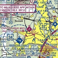
| Sectional chart |
|---|
|
| Airport distance calculator |
|---|
|
|
| Sunrise and sunset |
|---|
|
Times for 21-Apr-2025
| | Local
(UTC-5) | | Zulu
(UTC) |
|---|
| Morning civil twilight | | 05:32 | | 10:32 |
| Sunrise | | 06:02 | | 11:02 |
| Sunset | | 19:41 | | 00:41 |
| Evening civil twilight | | 20:11 | | 01:11 |
|
| Current date and time |
|---|
| Zulu (UTC) | 21-Apr-2025 10:48:01 |
|---|
| Local (UTC-5) | 21-Apr-2025 05:48:01 |
|---|
|
| METAR |
|---|
KUES
5nm SE | 211035Z AUTO 19005KT 10SM OVC015 12/12 A2960 RMK AO2
|
KMWC
7nm E | 211035Z AUTO 17007KT 10SM OVC020 10/10 A2961 RMK AO2
|
KMKE
15nm SE | 210952Z 17008KT 10SM BKN021 OVC028 10/08 A2961 RMK AO2 SLP031 T01000083
|
K57C
19nm SW | 211035Z AUTO 21009G18KT 7SM OVC014 13/13 A2960 RMK AO2 T01270125
|
KETB
20nm N | 211035Z AUTO 00000KT 10SM BKN012 OVC020 09/08 A2959 RMK AO2
|
|
| TAF |
|---|
KUES
5nm SE | 210825Z 2108/2206 14012KT P6SM BKN015 OVC022 WS020/17045KT TEMPO 2110/2111 6SM -RA BKN009 OVC015 FM211100 21012G22KT P6SM BKN012 FM211400 24017G30KT P6SM OVC009 FM212300 28016G28KT P6SM SCT040
|
KMKE
15nm SE | 210825Z 2108/2212 15012KT P6SM BKN020 WS020/18050KT TEMPO 2110/2111 6SM -RA BKN015 OVC020 FM211100 18012G22KT P6SM BKN026 FM211300 22014G25KT P6SM OVC012 FM211900 26019G33KT P6SM BKN023 FM212300 28015G25KT P6SM BKN040
|
|
| NOTAMs |
|---|
NOTAMs are issued by the DoD/FAA and will open in a separate window not controlled by AirNav.
|
|


