FAA INFORMATION EFFECTIVE 20 FEBRUARY 2025
Location
| FAA Identifier: | 4A9 |
| Lat/Long: | 34-28-25.3000N 085-43-17.0000W
34-28.421667N 085-43.283333W
34.4736944,-85.7213889
(estimated) |
| Elevation: | 876.7 ft. / 267.2 m (surveyed) |
| Variation: | 04W (2010) |
| From city: | 2 miles N of FORT PAYNE, AL |
| Time zone: | UTC -6 (UTC -5 during Daylight Saving Time) |
| Zip code: | 35968 |
Airport Operations
| Airport use: | Open to the public |
| Activation date: | 01/1959 |
| Control tower: | no |
| ARTCC: | ATLANTA CENTER |
| FSS: | ANNISTON FLIGHT SERVICE STATION |
| NOTAMs facility: | 4A9 (NOTAM-D service available) |
| Attendance: | 0700-1700
FOR SVC AFT HRS CALL 256-997-7524. |
| Wind indicator: | lighted |
| Segmented circle: | no |
| Lights: | MIRL RWY 4/22 PRESET LOW INTST, TO INCR INTST ACTVT - CTAF. REIL RWY 04 & 22 ACTVT - CTAF. PAPI RWYS 04 & 22 OPR CONSLY. |
| Beacon: | white-green (lighted land airport)
Operates sunset to sunrise. |
Airport Communications
| CTAF/UNICOM: | 122.8 |
| WX AWOS-3PT: | 119.025 (256-845-5397) |
| WX AWOS-3PT at 4A6 (19 nm NW): | 120.125 (256-259-1148) |
- APCH/DEP SVC PRVDD BY ATLANTA ARTCC ON FREQS 124.5/270.325 (GADSDEN RCAG).
Nearby radio navigation aids
| VOR radial/distance | | VOR name | | Freq | | Var |
|---|
| GADr029/34.8 | | GADSDEN VOR/DME | | 112.30 | | 02E |
| RMGr301/35.2 | | ROME VORTAC | | 115.40 | | 01E |
Airport Services
| Fuel available: | 100LL JET-A+ |
| Parking: | tiedowns |
Runway Information
Runway 4/22
| Dimensions: | 5001 x 100 ft. / 1524 x 30 m |
| Surface: | asphalt/grooved, in good condition |
| Weight bearing capacity: | |
| Runway edge lights: | medium intensity |
| RUNWAY 4 | | RUNWAY 22 |
| Latitude: | 34-28.104200N | | 34-28.739500N |
| Longitude: | 085-43.601027W | | 085-42.966895W |
| Elevation: | 855.8 ft. | | 873.1 ft. |
| Traffic pattern: | left | | left |
| Runway heading: | 044 magnetic, 040 true | | 224 magnetic, 220 true |
| Markings: | nonprecision, in fair condition | | nonprecision, in fair condition |
| Visual slope indicator: | 4-light PAPI on left (4.00 degrees glide path) | | 4-light PAPI on right (3.00 degrees glide path) |
| Runway end identifier lights: | yes | | yes |
| Touchdown point: | yes, no lights | | yes, no lights |
| Obstructions: | 60 ft. tree, lighted, 1528 ft. from runway, 194 ft. right of centerline, 22:1 slope to clear | | 97 ft. tree, 2369 ft. from runway, 340 ft. left of centerline, 22:1 slope to clear |
Airport Ownership and Management from official FAA records
| Ownership: | Publicly-owned |
| Owner: | CITY OF FORT PAYNE
100 ALABAMA AVE NW
FORT PAYNE, AL 35967
Phone 256-845-1524 |
| Manager: | BARRY STONE
2200 TERMINAL DRIVE NW
FORT PAYNE, AL 35968
Phone 256-845-9129 |
Additional Remarks
| - | FOR CD CTC ATLANTA ARTCC AT 770-210-7692. |
Instrument Procedures
NOTE: All procedures below are presented as PDF files. If you need a reader for these files, you should download the free Adobe Reader.NOT FOR NAVIGATION. Please procure official charts for flight.
FAA instrument procedures published for use from 20 February 2025 at 0901Z to 20 March 2025 at 0900Z.
IAPs - Instrument Approach Procedures |
|---|
| RNAV (GPS) RWY 04 | |
download (247KB) |
| RNAV (GPS) Y RWY 22 | |
download (238KB) |
| RNAV (GPS) Z RWY 22 | |
download (197KB) |
| NOTE: Special Alternate Minimums apply | |
download (154KB) |
| NOTE: Special Take-Off Minimums/Departure Procedures apply | |
download (480KB) |
Other nearby airports with instrument procedures:
4A6 - Scottsboro Municipal Airport-Word Field (19 nm NW)
KPYP - Centre Piedmont/Cherokee County Regional Airport (24 nm S)
9A5 - Barwick Lafayette Airport (25 nm NE)
8A1 - Guntersville Municipal Airport - Joe Starnes Field (27 nm W)
KRMG - Richard B. Russell Regional Airport - J.H. Towers Field (29 nm E)
|
|

Road maps at:
MapQuest
Bing
Google
| Aerial photo |
|---|
WARNING: Photo may not be current or correct
 Photo taken 01-Aug-2006
from a Cessna 340
Photo taken 01-Aug-2006
from a Cessna 340
Do you have a better or more recent aerial photo of Isbell Field Airport that you would like to share? If so, please send us your photo.
|
| Sectional chart |
|---|
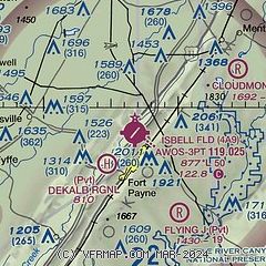
|
| Airport distance calculator |
|---|
|
|
| Sunrise and sunset |
|---|
|
Times for 13-Mar-2025
| | Local
(UTC-6) | | Zulu
(UTC) |
|---|
| Morning civil twilight | | 05:32 | | 11:32 |
| Sunrise | | 05:57 | | 11:57 |
| Sunset | | 17:48 | | 23:48 |
| Evening civil twilight | | 18:13 | | 00:13 |
|
| Current date and time |
|---|
| Zulu (UTC) | 13-Mar-2025 16:17:00 |
|---|
| Local (UTC-6) | 13-Mar-2025 10:17:00 |
|---|
|
| METAR |
|---|
| K4A9 | 131555Z AUTO 20008KT 10SM SCT022 BKN046 18/13 A2995 RMK AO2 T01780126
|
K4A6
19nm NW | 131555Z AUTO 22007G13KT 190V260 10SM BKN049 OVC060 19/13 A2995 RMK AO2
|
|
| TAF |
|---|
KCHA
42nm NE | 131120Z 1312/1412 VRB03KT P6SM BKN250 FM131600 19006KT P6SM SCT050 BKN200 FM140000 00000KT P6SM FEW100 FM141000 00000KT P6SM SCT035 BKN250
|
KHUA
49nm W | 131200Z 1312/1418 VRB06KT 9999 OVC150 QNH2986INS BECMG 1401/1402 VRB06KT 8000 BR BKN025 QNH2989INS BECMG 1408/1409 15006KT 8000 BR BKN003 QNH2988INS BECMG 1415/1416 15010G15KT 8000 BR SCT003 510033 QNH2991INS BECMG 1416/1417 17020G25KT 9000 BR BKN018 510033 QNH2988INS TX20/1320Z TN12/1312Z
|
|
| NOTAMs |
|---|
NOTAMs are issued by the DoD/FAA and will open in a separate window not controlled by AirNav.
|
|


