FAA INFORMATION EFFECTIVE 17 APRIL 2025
Location
| FAA Identifier: | 4B8 |
| Lat/Long: | 41-41-21.6000N 072-51-52.9000W
41-41.360000N 072-51.881667W
41.6893333,-72.8646944
(estimated) |
| Elevation: | 201.8 ft. / 61.5 m (surveyed) |
| Variation: | 14W (2000) |
| From city: | 2 miles N of PLAINVILLE, CT |
| Time zone: | UTC -4 (UTC -5 during Standard Time) |
| Zip code: | 06062 |
Airport Operations
| Airport use: | Open to the public |
| Activation date: | 10/1947 |
| Control tower: | no |
| ARTCC: | BOSTON CENTER |
| FSS: | BRIDGEPORT FLIGHT SERVICE STATION |
| NOTAMs facility: | BDR (NOTAM-D service available) |
| Attendance: | MON-FRI 0800-1900, ALL SAT-SUN 0800-1800 |
| Pattern altitude: | 1001.8 ft. MSL
TPA: 800 FT FOR ACFT LESS THAN 12500 LBS, 1300 FT FOR ACFT 12500 LBS & ABV. |
| Wind indicator: | lighted |
| Segmented circle: | no |
| Lights: | ACTVT REIL RWY 02 & 20; MIRL RWY 02/20 - CTAF. PAPI RWY 02 & 20 OPR CONSLY. |
| Beacon: | white-green (lighted land airport)
Operates sunset to sunrise. |
| Landing fee: | no, LDG FEE FOR COML AND CORPORATE ACFT ONLY. |
Airport Communications
| CTAF/UNICOM: | 122.8 |
| WX AWOS-3PT: | 119.175 (860-351-5362) |
| BRADLEY APPROACH: | 123.95 |
| BRADLEY DEPARTURE: | 123.95 |
| CLEARANCE DELIVERY: | 134.5 |
| WX AWOS-AV at CT71 (3 nm NE): | 129.825 |
| WX ASOS at HFD (10 nm E): | PHONE 860-527-5837 |
| WX ASOS at MMK (11 nm S): | 134.925 (203-639-9405) |
| WX ASOS at BDL (17 nm NE): | 118.15 (860-386-3480) |
| WX AWOS-3PT at OXC (18 nm SW): | 132.975 (203-262-1190) |
- VFR ARPT. PVT OWNED/OPERD RTR FREQ 124.55 CTLD BY BRADLEY APCH CTL TO PROVIDE CLEARANCE DELIVERY.
- APCH/DEP SVC PRVDD BY BDL (BRADLEY INTL, WINDSOR LOCKS, CT) APCH CNTL ON 123.95/290.55.
Nearby radio navigation aids
| VOR radial/distance | | VOR name | | Freq | | Var |
|---|
| HFDr295/14.5 | | HARTFORD VOR/DME | | 114.90 | | 13W |
| MADr354/23.8 | | MADISON VOR/DME | | 110.40 | | 13W |
| BAFr207/29.1 | | BARNES VORTAC | | 113.00 | | 14W |
| PWLr110/33.3 | | PAWLING VOR/DME | | 114.30 | | 12W |
| BDRr032/33.8 | | BRIDGEPORT VOR/DME | | 108.80 | | 12W |
| CTRr187/36.3 | | CHESTER VOR/DME | | 115.10 | | 13W |
| ORWr296/39.6 | | NORWICH VOR/DME | | 110.00 | | 14W |
Airport Services
| Fuel available: | 100LL JET-A |
| Parking: | hangars and tiedowns |
| Airframe service: | MAJOR |
| Powerplant service: | MAJOR |
| Bottled oxygen: | HIGH/LOW |
| Bulk oxygen: | NONE |
Runway Information
Runway 2/20
| Dimensions: | 3665 x 75 ft. / 1117 x 23 m |
| Surface: | asphalt, in good condition |
| Weight bearing capacity: | |
| Runway edge lights: | medium intensity |
| RUNWAY 2 | | RUNWAY 20 |
| Latitude: | 41-41.060177N | | 41-41.660968N |
| Longitude: | 072-51.919320W | | 072-51.844238W |
| Elevation: | 188.6 ft. | | 201.6 ft. |
| Traffic pattern: | left | | left |
| Runway heading: | 019 magnetic, 005 true | | 199 magnetic, 185 true |
| Markings: | nonprecision, in good condition | | nonprecision, in good condition |
| Visual slope indicator: | 2-light PAPI on left (3.00 degrees glide path) | | 2-light PAPI on right (3.50 degrees glide path) |
| Runway end identifier lights: | yes | | yes |
| Touchdown point: | yes, no lights | | yes, no lights |
| Obstructions: | 17 ft. trees, 250 ft. from runway, 67 ft. left of centerline, 2:1 slope to clear
10 FT BRUSH, 15 FT DSTC, 90 FT L. | | 50 ft. trees, 240 ft. from runway, 105 ft. right of centerline, 1:1 slope to clear |
Helipad H1
| Dimensions: | 30 x 30 ft. / 9 x 9 m |
| Surface: | asphalt, in good condition |
| Latitude: | 41-41.422600N | | |
| Longitude: | 072-51.889350W | | |
| Elevation: | 200.0 ft. | | |
| Traffic pattern: | left | | left |
| Markings: | basic, in good condition | | |
Airport Ownership and Management from official FAA records
| Ownership: | Publicly-owned |
| Owner: | TOWN OF PLAINVILLE
1 CENTRAL SQUARE
PLAINVILLE, CT 06062
Phone 860-793-0221 |
| Manager: | NICHOLAS SCATA
62 JOHNSON AVE
PLAINVILLE, CT 06062
Phone 860-747-5519 |
Additional Remarks
| - | NOISE ABATEMENT PROCS IN EFCT. CTC 1-800-573-5519 OR 860-747-5519 FOR DTLS. |
| - | FOR CD CTC YANKEE APCH AT 860-386-3597. |
| - | CTN DEER & BIRDS ON & INVOF ARPT. |
Instrument Procedures
NOTE: All procedures below are presented as PDF files. If you need a reader for these files, you should download the free Adobe Reader.NOT FOR NAVIGATION. Please procure official charts for flight.
FAA instrument procedures published for use from 17 April 2025 at 0901Z to 15 May 2025 at 0900z.
IAPs - Instrument Approach Procedures |
|---|
| RNAV (GPS) RWY 02 **CHANGED** | |
download (205KB) |
| RNAV (GPS) RWY 20 **NEW** | |
download (199KB) |
| NOTE: Special Alternate Minimums apply **CHANGED** | |
download (152KB) |
| NOTE: Special Take-Off Minimums/Departure Procedures apply | |
download (510KB) |
Other nearby airports with instrument procedures:
KHFD - Hartford-Brainard Airport (10 nm E)
KMMK - Meriden Markham Municipal Airport (11 nm S)
KBDL - Bradley International Airport (17 nm NE)
KOXC - Waterbury-Oxford Airport (18 nm SW)
KSNC - Chester Airport (24 nm SE)
|
|

Road maps at:
MapQuest
Bing
Google
| Aerial photo |
|---|
WARNING: Photo may not be current or correct
 Photo taken 25-Mar-2015
looking east.
Photo taken 25-Mar-2015
looking east.
Do you have a better or more recent aerial photo of Robertson Field Airport that you would like to share? If so, please send us your photo.
|
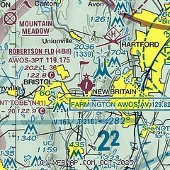
| Sectional chart |
|---|
|
| Airport distance calculator |
|---|
|
|
| Sunrise and sunset |
|---|
|
Times for 30-Apr-2025
| | Local
(UTC-4) | | Zulu
(UTC) |
|---|
| Morning civil twilight | | 05:20 | | 09:20 |
| Sunrise | | 05:50 | | 09:50 |
| Sunset | | 19:47 | | 23:47 |
| Evening civil twilight | | 20:17 | | 00:17 |
|
| Current date and time |
|---|
| Zulu (UTC) | 01-May-2025 01:18:21 |
|---|
| Local (UTC-4) | 30-Apr-2025 21:18:21 |
|---|
|
| METAR |
|---|
KHFD
10nm E | 010053Z 32005KT 10SM CLR 16/01 A3006 RMK AO2 SLP179 T01610006
|
KMMK
10nm S | 010053Z AUTO 00000KT 10SM CLR 15/02 A3007 RMK AO2 SLP182 T01500017
|
KBDL
17nm NE | 010051Z 30008KT 10SM FEW250 14/01 A3006 RMK AO2 SLP180 T01440006
|
KOXC
18nm SW | 010056Z 35004KT 10SM CLR 12/M01 A3008 RMK AO2 SLP199 T01171011
|
|
| TAF |
|---|
KBDL
17nm NE | 302000Z 3020/0124 31010G19KT P6SM FEW250 FM010000 31005KT P6SM FEW250 FM011600 19008KT P6SM FEW200
|
|
| NOTAMs |
|---|
NOTAMs are issued by the DoD/FAA and will open in a separate window not controlled by AirNav.
|
|


