FAA INFORMATION EFFECTIVE 17 APRIL 2025
Location
| FAA Identifier: | 77G |
| Lat/Long: | 43-18-42.5990N 083-05-27.3130W
43-18.709983N 083-05.455217W
43.3118331,-83.0909203
(estimated) |
| Elevation: | 894.9 ft. / 272.8 m (surveyed) |
| Variation: | 08W (2010) |
| From city: | 1 mile SW of MARLETTE, MI |
| Time zone: | UTC -4 (UTC -5 during Standard Time) |
| Zip code: | 48453 |
Airport Operations
| Airport use: | Open to the public |
| Activation date: | 05/1975 |
| Control tower: | no |
| ARTCC: | CLEVELAND CENTER |
| FSS: | LANSING FLIGHT SERVICE STATION |
| NOTAMs facility: | LAN (NOTAM-D service available) |
| Attendance: | UNATNDD |
| Wind indicator: | lighted |
| Segmented circle: | yes |
| Lights: | ACTVT PAPI RWY 01, 19, 10, & 28; MIRL RWY 01/19 & 10/28 - CTAF. |
| Beacon: | white-green (lighted land airport)
Operates sunset to sunrise. |
Airport Communications
| CTAF/UNICOM: | 122.8 |
| WX AWOS-3P at D95 (17 nm SW): | 134.050 (810-664-5038) |
| WX AWOS-3 at CFS (18 nm NW): | 119.275 (989-672-4182) |
- APCH/DEP SVC PRVDD BY CLEVELAND ARTCC (ZOB) ON FREQS 127.7/290.425 (FREELAND RCAG) .
Nearby radio navigation aids
| VOR radial/distance | | VOR name | | Freq | | Var |
|---|
| FNTr060/35.4 | | FLINT VORTAC | | 116.90 | | 06W |
Airport Services
| Fuel available: | 100LL
100LL:AVBL H24 SELF SVC VIA CREDIT CARD. |
| Parking: | hangars and tiedowns |
Runway Information
Runway 10/28
| Dimensions: | 3795 x 75 ft. / 1157 x 23 m |
| Surface: | asphalt, in fair condition |
| Runway edge lights: | medium intensity |
| RUNWAY 10 | | RUNWAY 28 |
| Latitude: | 43-18.615670N | | 43-18.621265N |
| Longitude: | 083-05.844670W | | 083-04.989263W |
| Elevation: | 871.7 ft. | | 879.2 ft. |
| Traffic pattern: | left | | left |
| Runway heading: | 097 magnetic, 089 true | | 277 magnetic, 269 true |
| Markings: | nonprecision, in good condition | | nonprecision, in good condition |
| Visual slope indicator: | 2-light PAPI on right (3.00 degrees glide path) | | 2-light PAPI on left (3.00 degrees glide path) |
| Touchdown point: | yes, no lights | | yes, no lights |
| Obstructions: | none | | 28 ft. tree, 595 ft. from runway, 180 ft. right of centerline, 14:1 slope to clear |
Runway 1/19
| Dimensions: | 3500 x 75 ft. / 1067 x 23 m |
| Surface: | asphalt, in good condition |
| Runway edge lights: | medium intensity |
| RUNWAY 1 | | RUNWAY 19 |
| Latitude: | 43-18.521752N | | 43-19.096642N |
| Longitude: | 083-05.522795W | | 083-05.470555W |
| Elevation: | 870.8 ft. | | 894.9 ft. |
| Traffic pattern: | left | | left |
| Runway heading: | 012 magnetic, 004 true | | 192 magnetic, 184 true |
| Markings: | nonprecision, in good condition | | nonprecision, in good condition |
| Visual slope indicator: | 2-light PAPI on left (3.00 degrees glide path) | | 2-light PAPI on left (3.00 degrees glide path) |
| Runway end identifier lights: | no | | no |
| Touchdown point: | yes, no lights | | yes, no lights |
| Obstructions: | none
0-8 FT SEASONAL CROPS, 230 FT DIST. | | 26 ft. tree, 345 ft. from runway, 130 ft. left of centerline, 5:1 slope to clear |
Airport Ownership and Management from official FAA records
| Ownership: | Publicly-owned |
| Owner: | MARLETTE TOWNSHIP
6725 AIRPORT RD
MARLETTE, MI 48453-8210
Phone 989-635-7772 |
| Manager: | PHIL ROACH
6725 AIRPORT RD
MARLETTE, MI 48453-8210
Phone 810-459-4674 |
Additional Remarks
| - | FOR CD CTC CLEVELAND ARTCC AT 440-774-0224/0490. |
| - | DEER & LRG BIRDS ON & INVOF ARPT. |
Instrument Procedures
NOTE: All procedures below are presented as PDF files. If you need a reader for these files, you should download the free Adobe Reader.NOT FOR NAVIGATION. Please procure official charts for flight.
FAA instrument procedures published for use from 17 April 2025 at 0901Z to 15 May 2025 at 0900z.
IAPs - Instrument Approach Procedures |
|---|
| RNAV (GPS) RWY 10 | |
download (202KB) |
| RNAV (GPS) RWY 19 | |
download (223KB) |
| RNAV (GPS) RWY 28 | |
download (209KB) |
| NOTE: Special Take-Off Minimums/Departure Procedures apply | |
download (347KB) |
Other nearby airports with instrument procedures:
Y83 - Sandusky City Airport (14 nm NE)
D95 - Dupont/Lapeer Airport (17 nm SW)
KCFS - Tuscola Area Airport (18 nm NW)
KBAX - Huron County Memorial Airport (28 nm N)
D98 - Romeo State Airport (31 nm S)
|
|

Road maps at:
MapQuest
Bing
Google
| Aerial photo |
|---|
WARNING: Photo may not be current or correct
 Photo courtesy of AirNav, LLC
Photo taken 28-Jul-2011
looking north.
Photo courtesy of AirNav, LLC
Photo taken 28-Jul-2011
looking north.
Do you have a better or more recent aerial photo of Marlette Township Airport that you would like to share? If so, please send us your photo.
|
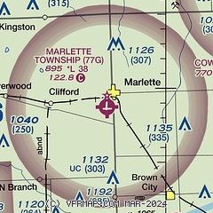
| Sectional chart |
|---|
|
| Airport distance calculator |
|---|
|
|
| Sunrise and sunset |
|---|
|
Times for 01-May-2025
| | Local
(UTC-4) | | Zulu
(UTC) |
|---|
| Morning civil twilight | | 05:55 | | 09:55 |
| Sunrise | | 06:26 | | 10:26 |
| Sunset | | 20:33 | | 00:33 |
| Evening civil twilight | | 21:04 | | 01:04 |
|
| Current date and time |
|---|
| Zulu (UTC) | 01-May-2025 11:40:38 |
|---|
| Local (UTC-4) | 01-May-2025 07:40:38 |
|---|
|
| METAR |
|---|
KD95
17nm SW | 011115Z AUTO 07006KT 10SM RA SCT035 SCT050 OVC100 06/05 A2996 RMK AO2 T00580050
|
KCFS
18nm NW | 011115Z AUTO 10004KT 7SM RA SCT030 OVC039 06/04 A2999 RMK AO2 T00550042
|
KBAX
29nm N | 011115Z AUTO 16003KT 10SM -RA OVC050 06/02 A3002 RMK AO2 T00580015
|
|
| TAF |
|---|
KFNT
36nm SW | 010525Z 0106/0206 14007KT P6SM OVC100 FM011000 09010KT 6SM -SHRA OVC040 FM011200 12010KT 5SM -SHRA OVC025 FM011700 15013KT P6SM BKN025 OVC040 PROB30 0122/0124 4SM RA OVC025 FM020300 25010KT P6SM BKN025
|
CYZR
39nm SE | 010740Z 0108/0120 06005KT P6SM BKN060 OVC120 TEMPO 0108/0110 BKN040 OVC060 FM011000 09008KT P6SM -SHRA BKN040 OVC060 PROB30 0110/0114 VRB15G25KT 4SM TSRA BR BKN020 OVC040CB FM011400 12008KT P6SM BKN040 OVC120 FM011600 12015G25KT 4SM SHRA BR BKN015 OVC040 PROB30 0116/0120 VRB20G30KT 1SM +TSRA BR BKN008 OVC040CB RMK FCST BASED ON AUTO OBS. NXT FCST BY 011400Z
|
KPTK
41nm S | 010904Z 0109/0206 11010KT 6SM -SHRA SCT025 OVC040 TEMPO 0109/0111 3SM TSRA OVC030CB FM011300 12010KT 5SM -SHRA OVC025 FM011600 15013KT 4SM SHRA BR OVC008 FM011900 22015G25KT P6SM BKN025 OVC040 PROB30 0122/0124 4SM RA OVC025 FM020300 24012KT P6SM BKN025
|
KMTC
43nm S | 301900Z 3019/0201 11003KT 9999 SKC QNH3013INS BECMG 0103/0104 10006KT 9999 -RA FEW085 FEW130 BKN180 QNH3008INS BECMG 0110/0111 10006KT 9999 -RA FEW030 OVC045 QNH2999INS BECMG 0115/0116 11010G20KT 9999 -RA FEW020 BKN025 OVC040 520006 QNH2989INS BECMG 0121/0122 15015G25KT 9999 RA BKN030 OVC050 520006 QNH2960INS TX13/0118Z TN06/0111Z LAST NO AMDS AFT 0103 NEXT 0111
|
|
| NOTAMs |
|---|
NOTAMs are issued by the DoD/FAA and will open in a separate window not controlled by AirNav.
|
|


