FAA INFORMATION EFFECTIVE 17 APRIL 2025
Location
| FAA Identifier: | MTC |
| Lat/Long: | 42-36-50.0170N 082-50-12.8750W
42-36.833617N 082-50.214583W
42.6138936,-82.8369097
(estimated) |
| Elevation: | 579.5 ft. / 176.6 m (surveyed) |
| Variation: | 06W (1985) |
| From city: | 2 miles NE of MOUNT CLEMENS, MI |
| Time zone: | UTC -4 (UTC -5 during Standard Time) |
| Zip code: | 48045 |
Airport Operations
| Airport use: | Private use. Permission required prior to landing |
| Activation date: | 05/1941 |
| Control tower: | yes |
| ARTCC: | CLEVELAND CENTER |
| FSS: | LANSING FLIGHT SERVICE STATION |
| NOTAMs facility: | MTC (NOTAM-D service available) |
| Attendance: | 1230-0400Z++
EXC HOL, OT UNCTL FOR DHS, ARNG, USCG OR EMEGENCY OPS. |
| Pattern altitude: | OVERHEAD TFC PAT 2500'. TRANS VFR JET ACFT NOT AUTH RECT TFC PAT. |
| Wind indicator: | yes |
| Segmented circle: | no |
| Lights: | ACTVT SALS RWY 01; ALSF-1 RWY 19; REIL RWY 19; HIRL RWY 01/19 - 120.15. PAPI RWY 01 & 19 OTS INDEFLY. |
| Beacon: | white-green (lighted land airport)
Operates sunset to sunrise. |
Airport Communications
| ATIS: | 125.325 270.1 |
| SELFRIDGE GROUND: | 128.3 275.8 [1230-0400Z++, CLSD HOL. OT UNCONTROLLED FOR DHS, ARNG, USCG OR EMERGENCY OPS.] |
| SELFRIDGE TOWER: | 120.15 225.4 [1230-0400Z++, CLSD HOL. OT UNCONTROLLED FOR DHS, ARNG, USCG OR EMERGENCY OPS.] |
| SELFRIDGE APPROACH: | 132.35 119.6 318.2 [1200-0400Z++] |
| SELFRIDGE DEPARTURE: | 132.35 119.6 391.9 [1200-0400Z++] |
| CLEARANCE DELIVERY: | 128.3 275.8 |
| BARII DP: | 119.6 |
| CCOBB DP: | 119.6 |
| CG OPS: | 157.075 ;USCG DETROIT AIR 345.0 ;USCG DETROIT AIR 381.8 ;USCG DETROIT AIR 5692 ;USCG DETROIT AIR |
| CLVIN DP: | 119.6 |
| COMD POST: | 311.0 ;WING COMD POST QUARTER BACK C 321.0 ;WING COMD POST QUARTER BACK C 349.4 ;WING CMD POST |
| EMERG: | 121.5 243.0 |
| GGIBY DP: | 119.6 |
| HHOWE DP: | 119.6 |
| KAYLN DP: | 119.6 |
| LIDDS DP: | 119.6 |
| MEDEVAC: | 123.1 262.8 381.0 |
| MIGGY DP: | 119.6 |
| NAF OPS: | 318.6 |
| PAVYL DP: | 119.6 |
| PTD: | 372.2 |
| SFA: | 259.3 290.9 388.2 391.9 |
| SNDRS DP: | 119.6 |
| ZETTR DP: | 119.6 |
| WX ASOS at DET (14 nm SW): | PHONE 313-371-9696 |
| WX AWOS-3 at VLL (16 nm W): | 119.475 (248-288-4649) |
Nearby radio navigation aids
| VOR radial/distance | | VOR name | | Freq | | Var |
|---|
| DXOr050/33.6 | | DETROIT VOR/DME | | 113.40 | | 06W |
| SVMr073/35.7 | | SALEM VORTAC | | 114.30 | | 03W |
Airport Services
| Parking: | hangars |
| Airframe service: | MAJOR |
| Powerplant service: | MAJOR |
| Bottled oxygen: | NONE |
| Bulk oxygen: | HIGH/LOW |
Runway Information
Runway 1/19
| Dimensions: | 9000 x 150 ft. / 2743 x 46 m
500' ASPHALT OVERRUN EACH END RWY 01-19. |
| Surface: | PEM
S 1500 FT CONC, CNTR 5700 FT ASPH, N 1800 FT CON. |
| Weight bearing capacity: | |
| Runway edge lights: | high intensity |
| RUNWAY 1 | | RUNWAY 19 |
| Latitude: | 42-36.093000N | | 42-37.574333N |
| Longitude: | 082-50.240333W | | 082-50.188833W |
| Elevation: | 579.4 ft. | | 578.8 ft. |
| Traffic pattern: | right | | right |
| Runway heading: | 008 magnetic, 002 true | | 188 magnetic, 182 true |
| Markings: | precision, in good condition | | precision, in good condition |
| Visual slope indicator: | 4-light PAPI on left (3.00 degrees glide path) | | 4-light PAPI on left (3.00 degrees glide path) |
| RVR equipment: | touchdown | | touchdown |
| Approach lights: | SALS | | ALSF1: standard 2,400 foot high intensity approach lighting system with centerline sequenced flashers (category I) |
| Runway end identifier lights: | no | | yes |
| Touchdown point: | yes, no lights | | yes, no lights |
| Instrument approach: | LOC/GS | | ILS |
Airport Ownership and Management from official FAA records
| Ownership: | U.S. Air Force |
| Owner: | USAF
MI ANG, SELFRIDGE ANGB
MT CLEMENS, MI 48045
Phone 586-239-5322 |
| Manager: | CHIEF OF AFLD MANAGEMENT
MI ANG, SELFRIDGE ANGB
MT CLEMENS, MI 48045
Phone 586-239-4115 |
Additional Remarks
| - | WX BRIEFING AVBL 1115-0315Z++, 1115-2015Z++ HOLS. |
| - | SNOW REMOVAL 1215-2100Z++ MON THRU FRI. |
| - | A++ FUEL AVBL 1200-0000Z++ MON-FRI 1430-2100Z++ SAT-SUN, CLSD HOL. |
| - | FLUID: SP PRESAIR LPOX LOX HPOX. |
| - | OIL; O-128-133-148 (SOAP 1215-2115++ MON FRI, OT DSN 273-5777.) |
| - | TRAN ALERT; OPR 1230-0130Z++. TRAN ALERT & FUELS CLSD HOL. |
| - | MISC; VIP ACFT CTC PTS 30 MIN PRIOR TO ARR WITH FIRM CHOCK TIME. BASE OPS DSN 273-5322, C586-239-5322, FAX DSN273-5814, C586-239-5814, NOTAM DSN 273-4069 C586-239-4069. |
| - | MISC; SNOW REMOVAL ACCOMPLISHED 1215-2100Z++ WKD. |
| - | MISC; TRAN ACFT REQ USE OF SELFRIDGE ANGB DROP ZONE (DZS). |
| - | MISC: STD USAF RSRS APPLIED. CLASS D AIRSPACE CONT. |
| - | MISC; RY 01-19 TRANSVERSELY GROOVED. RY 01-19 S 1500' CONCRETE, CNTR 5700' ASPHALT, N 1800' CONCRETE. RY 01-19 S OVRN HARDENED MAY BE USED FOR TKOF , DAY VFR ONLY. |
| - | BEARING STRENGTH; RY 01-19; ST 175. |
| - | CAUTION: MODERATE BIRD ACT COMMON. |
| - | PPR CTC BASOPS 1230-0400Z++ DSN 273-5322 C586-239-5322/4402. PPR REQ MUST BE SMTD 72 HRS IN ADVN DURG OPRG HRS; 14 DAYS IN ADVN OUTSIDE OPRG HRS. PPR VALID WI 1 HR DURG OPRG HRS & WI 15 MINS OUTSIDE OPRG HRS. IF OUTSIDE APVD TIME SLOT CTC BASOPS TO UPDT PPR. |
| - | HAZ CARGO PAD CAN ACCOM C-130, DAY ONLY & LTD C-17 USE. NO TIE DOWN, NOR LONG TERM PARKING ON PAD. |
| - | CAUTION: USCG & EAST RAMP WIND CONES UNLGTD; DAY USE ONLY. |
| - | CAUTION: RWYCC NOT RPT. |
| - | CAUTION: ALL TWYS HAVE CHIPPED AND/OR FADED MKR. |
| - | MISC: RSC/RCR NOT RPRTD OUTSIDE OF OPRG HRS. |
| - | FIGHTER RECTANGULAR & CLSD TRAFFIC PATTERN IS 2200 FT; ALL OTHERS TPS 1700 FT. JASU 1(M32A-60); 1(A/M32-86D) 1(MC-11). |
Instrument Procedures
NOTE: All procedures below are presented as PDF files. If you need a reader for these files, you should download the free Adobe Reader.NOT FOR NAVIGATION. Please procure official charts for flight.
FAA instrument procedures published for use from 17 April 2025 at 0901Z to 15 May 2025 at 0900z.
Other nearby airports with instrument procedures:
57D - Ray Community Airport (8 nm N)
D98 - Romeo State Airport (13 nm NW)
KDET - Coleman A Young Municipal Airport (14 nm SW)
KVLL - Oakland/Troy Airport (16 nm W)
KPHN - St Clair County International Airport (22 nm NE)
|
|

Road maps at:
MapQuest
Bing
Google
| Aerial photo |
|---|

|
| Sectional chart |
|---|
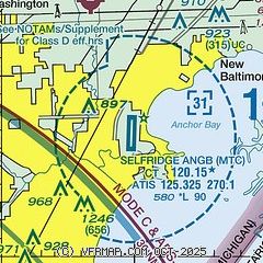
|
 Download PDF
of official airport diagram from the FAA
| Airport distance calculator |
|---|
|
|
| Sunrise and sunset |
|---|
|
Times for 01-May-2025
| | Local
(UTC-4) | | Zulu
(UTC) |
|---|
| Morning civil twilight | | 05:56 | | 09:56 |
| Sunrise | | 06:27 | | 10:27 |
| Sunset | | 20:30 | | 00:30 |
| Evening civil twilight | | 21:01 | | 01:01 |
|
| Current date and time |
|---|
| Zulu (UTC) | 02-May-2025 02:57:55 |
|---|
| Local (UTC-4) | 01-May-2025 22:57:55 |
|---|
|
| METAR |
|---|
| KMTC | 020256Z 21008KT 10SM SCT034 BKN090 BKN200 17/15 A2964 RMK AO2A SLP042 60003 T01730149 53012 $
|
KDET
15nm SW | 020253Z 24011G18KT 10SM CLR 18/14 A2969 RMK AO2 SLP051 60001 T01830139 53015
|
KVLL
16nm W | 020235Z AUTO 22006KT 10SM FEW032 16/15 A2967 RMK AO2
|
|
| TAF |
|---|
| KMTC | 020030Z 0200/0301 15010KT 9999 FEW030 SCT100 BKN180 QNH2961INS TEMPO 0201/0203 24015G25KT 4800 -TSRA BKN030CB BECMG 0206/0208 25010G18KT 9999 NSW BKN017 OVC025 QNH2971INS BECMG 0209/0211 25006KT 9000 RA OVC010 QNH2972INS TX17/0200Z TN10/0205Z LAST NO AMDS AFT 0203 NEXT 0311
|
KDET
15nm SW | 012227Z 0122/0218 20015G30KT P6SM BKN045 TEMPO 0200/0201 4SM -TSRA OVC025CB FM020100 22012KT P6SM OVC035 FM020600 23012KT P6SM OVC025 FM021200 24005KT P6SM OVC015 PROB30 0212/0215 P6SM -RA OVC015
|
|
| NOTAMs |
|---|
NOTAMs are issued by the DoD/FAA and will open in a separate window not controlled by AirNav.
|
|


