FAA INFORMATION EFFECTIVE 17 APRIL 2025
Location
| FAA Identifier: | 78I |
| Lat/Long: | 39-30-05.9300N 086-41-18.6065W
39-30.098833N 086-41.310108W
39.5016472,-86.6885018
(estimated) |
| Elevation: | 791 ft. / 241 m (estimated) |
| Variation: | 02W (1990) |
| From city: | 3 miles SW of EMINENCE, IN |
| Time zone: | UTC -4 (UTC -5 during Standard Time) |
| Zip code: | 46120 |
Airport Operations
| Airport use: | Open to the public |
| Activation date: | 08/1994 |
| Control tower: | no |
| ARTCC: | INDIANAPOLIS CENTER |
| FSS: | TERRE HAUTE FLIGHT SERVICE STATION |
| NOTAMs facility: | HUF (NOTAM-D service available) |
| Attendance: | IRREG. |
| Wind indicator: | yes |
| Segmented circle: | no |
Airport Communications
| CTAF: | 122.9 |
| WX AWOS-3PT at GPC (10 nm NW): | 118.125 (765-653-1789) |
| WX AWOS-3PT at 2R2 (18 nm NE): | 118.025 (317-718-4872) |
Nearby radio navigation aids
| VOR radial/distance | | VOR name | | Freq | | Var |
|---|
| OOMr353/21.8 | | HOOSIER VORTAC | | 110.20 | | 02W |
| VHPr217/23.9 | | BRICKYARD VORTAC | | 116.30 | | 01E |
| TTHr086/26.0 | | TERRE HAUTE VORTAC | | 115.30 | | 02E |
| NDB name | | Hdg/Dist | | Freq | | Var | | ID |
|---|
| CRAWFORDSVILLE | | 164/30.6 | | 388 | | 04W | | CFJ | -.-. ..-. .--- |
Airport Services
| Parking: | hangars and tiedowns |
| Airframe service: | MINOR |
| Powerplant service: | MINOR |
Runway Information
Runway 10/28
| Dimensions: | 3630 x 100 ft. / 1106 x 30 m |
| Surface: | turf, in good condition |
| Runway edge markings: | RWY EDGE MKD WITH GRASSLINE; DSPLCD THR MKD WITH 3 TRAFFIC CONES. |
| RUNWAY 10 | | RUNWAY 28 |
| Latitude: | 39-30.081667N | | 39-30.008000N |
| Longitude: | 086-41.795333W | | 086-41.029167W |
| Elevation: | 775.0 ft. | | 791.0 ft. |
| Traffic pattern: | left | | left |
| Displaced threshold: | 745 ft. | | 930 ft. |
| Obstructions: | 82 ft. trees, 120 ft. from runway, 135 ft. left of centerline, 1:1 slope to clear | | 64 ft. tree, 1165 ft. from runway, 110 ft. left of centerline, 18:1 slope to clear |
Runway 18/36
| Dimensions: | 1629 x 100 ft. / 497 x 30 m |
| Surface: | turf, in good condition |
| RUNWAY 18 | | RUNWAY 36 |
| Latitude: | 39-30.353333N | | 39-30.085000N |
| Longitude: | 086-41.080000W | | 086-41.085000W |
| Elevation: | 770.0 ft. | | 784.0 ft. |
| Traffic pattern: | left | | left |
| Obstructions: | 22 ft. pole, 325 ft. from runway, 150 ft. left of centerline, 14:1 slope to clear | | 68 ft. tree, 920 ft. from runway, 167 ft. left of centerline, 13:1 slope to clear |
Airport Ownership and Management from official FAA records
| Ownership: | Privately-owned |
| Owner: | BLUE SKIES AVIATION LLC
13879 W PAMS WAY
CLOVERDALE, IN 46120
Phone 217-274-1999 |
| Manager: | TRACY POTTER
13879 W PAMS WAY
CLOVERDALE, IN 46120
Phone 217-274-1999 |
Additional Remarks
| A30A-10 | 75-150 FT TREES BOTH SIDES OF CNTRLN 300 FT FM RWY. |
| - | DEER & BIRDS ON & INVOF ARPT. |
| - | FOR CD CTC INDIANAPOLIS APCH AT 317-227-5743. |
| - | 24 HR EMERG FONE LCTD IN BLUE CONTAINER ON WALL OF SW BLDG. |
Instrument Procedures
There are no published instrument procedures at 78I.
Some nearby airports with instrument procedures:
KGPC - Putnam County Regional Airport (10 nm NW)
2R2 - Hendricks County Airport-Gordon Graham Field (18 nm NE)
0I2 - Brazil Clay County Airport (19 nm W)
KBMG - Monroe County Airport (22 nm S)
KIND - Indianapolis International Airport (22 nm NE)
|
|

Road maps at:
MapQuest
Bing
Google
| Aerial photo |
|---|
WARNING: Photo may not be current or correct
 Photo by Ty Sundstrom.
Photo taken 05-Jun-2009
Photo by Ty Sundstrom.
Photo taken 05-Jun-2009
Do you have a better or more recent aerial photo of Pam's Place Airport that you would like to share? If so, please send us your photo.
|
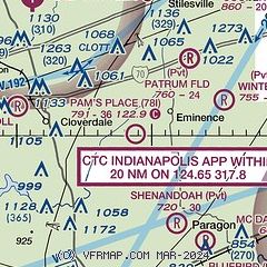
| Sectional chart |
|---|
|
| Airport distance calculator |
|---|
|
|
| Sunrise and sunset |
|---|
|
Times for 24-Apr-2025
| | Local
(UTC-4) | | Zulu
(UTC) |
|---|
| Morning civil twilight | | 06:29 | | 10:29 |
| Sunrise | | 06:58 | | 10:58 |
| Sunset | | 20:32 | | 00:32 |
| Evening civil twilight | | 21:01 | | 01:01 |
|
| Current date and time |
|---|
| Zulu (UTC) | 24-Apr-2025 04:45:30 |
|---|
| Local (UTC-4) | 24-Apr-2025 00:45:30 |
|---|
|
| METAR |
|---|
KGPC
10nm NW | 240435Z AUTO 13003KT 10SM CLR 17/04 A3014 RMK AO2 T01750043
|
|
| TAF |
|---|
KBMG
21nm S | 231724Z 2318/2418 13006KT P6SM SCT250 FM240200 00000KT P6SM FEW250 FM241400 13004KT P6SM FEW040 FEW250
|
KIND
23nm NE | 240225Z 2402/2506 14003KT P6SM BKN250 FM240800 09004KT P6SM SCT250 FM241600 16008KT P6SM FEW040 FEW250 FM241800 18010KT P6SM VCSH SCT040 BKN250
|
|
| NOTAMs |
|---|
NOTAMs are issued by the DoD/FAA and will open in a separate window not controlled by AirNav.
|
|


