FAA INFORMATION EFFECTIVE 20 FEBRUARY 2025
Location
| FAA Identifier: | 8C4 |
| Lat/Long: | 41-45-48.0750N 091-09-10.5690W
41-45.801250N 091-09.176150W
41.7633542,-91.1529358
(estimated) |
| Elevation: | 840 ft. / 256 m (estimated) |
| Variation: | 02E (1985) |
| From city: | 2 miles SW of TIPTON, IA |
| Time zone: | UTC -6 (UTC -5 during Daylight Saving Time) |
| Zip code: | 52772 |
Airport Operations
| Airport use: | Open to the public |
| Activation date: | 08/1969 |
| Control tower: | no |
| ARTCC: | CHICAGO CENTER |
| FSS: | FORT DODGE FLIGHT SERVICE STATION |
| NOTAMs facility: | FOD (NOTAM-D service available) |
| Attendance: | UNATNDD |
| Wind indicator: | lighted |
| Segmented circle: | no |
| Lights: | SS-SR |
Airport Communications
| CTAF: | 122.9 |
| CEDAR RAPIDS APPROACH: | 119.7 [0600-2130] |
| CEDAR RAPIDS DEPARTURE: | 119.7 [0600-2130] |
| WX ASOS at IOW (19 nm SW): | 128.075 (319-339-9491) |
- APCH/DEP SVC PRVDD BY CHICAGO ARTCC ON FREQS 132.8/328.4 (CEDAR RAPIDS RCAG) WHEN CEDAR RAPIDS APCH CTL CLSD.
Nearby radio navigation aids
| VOR radial/distance | | VOR name | | Freq | | Var |
|---|
| IOWr050/25.3 | | IOWA CITY VOR/DME | | 116.20 | | 05E |
| CIDr100/29.3 | | CEDAR RAPIDS VOR/DME | | 114.10 | | 05E |
| CVAr272/30.2 | | DAVENPORT VORTAC | | 113.80 | | 04E |
| MZVr314/35.2 | | MOLINE VOR/DME | | 114.40 | | 05E |
Airport Services
| Fuel available: | 100LL |
| Parking: | tiedowns |
| Airframe service: | NONE |
| Powerplant service: | NONE |
| Bottled oxygen: | NONE |
| Bulk oxygen: | NONE |
Runway Information
Runway 11/29
| Dimensions: | 3000 x 60 ft. / 914 x 18 m |
| Surface: | concrete, in fair condition |
| Weight bearing capacity: | |
| Runway edge lights: | medium intensity |
| RUNWAY 11 | | RUNWAY 29 |
| Latitude: | 41-45.887167N | | 41-45.715500N |
| Longitude: | 091-09.485500W | | 091-08.866833W |
| Elevation: | 840.0 ft. | | 840.0 ft. |
| Traffic pattern: | left | | left |
| Runway heading: | 108 magnetic, 110 true | | 288 magnetic, 290 true |
| Markings: | basic, in fair condition | | basic, in fair condition |
| Runway end identifier lights: | yes | | |
| Touchdown point: | yes, no lights | | yes, no lights |
| Obstructions: | 70 ft. trees, 3042 ft. from runway, 7 ft. right of centerline, 40:1 slope to clear | | 20 ft. road, 450 ft. from runway, 150 ft. right of centerline, 12:1 slope to clear |
Airport Ownership and Management from official FAA records
| Ownership: | Publicly-owned |
| Owner: | CITY OF TIPTON
407 LYNN ST.
TIPTON, IA 52772
Phone 563-886-6187
BRIAN WAGNER - CITY ADMINISTRATOR. |
| Manager: | MAX COPPESS
303 2ND AVENUE
STANWOOD, IA 52337
Phone 563-212-3308
OR 563-886-6187 |
Additional Remarks
| - | RY 29 IS CALM WIND RY. |
| - | DEER AND WATERFOWL ON AND INVOF OF ARPT. |
| - | FOR CD CTC CHICAGO ARTCC AT 630-906-8921. |
Instrument Procedures
NOTE: All procedures below are presented as PDF files. If you need a reader for these files, you should download the free Adobe Reader.NOT FOR NAVIGATION. Please procure official charts for flight.
FAA instrument procedures published for use from 20 February 2025 at 0901Z to 20 March 2025 at 0900Z.
IAPs - Instrument Approach Procedures |
|---|
| RNAV (GPS) RWY 11 | |
download (175KB) |
| VOR RWY 11 | |
download (186KB) |
| NOTE: Special Take-Off Minimums/Departure Procedures apply | |
download (421KB) |
Other nearby airports with instrument procedures:
KIOW - Iowa City Municipal Airport (19 nm SW)
C17 - Marion Airport (23 nm NW)
KMUT - Muscatine Municipal Airport (24 nm S)
KOQW - Maquoketa Municipal Airport (25 nm NE)
KCID - The Eastern Iowa Airport (26 nm W)
|
|

Road maps at:
MapQuest
Bing
Google
| Aerial photo |
|---|
WARNING: Photo may not be current or correct
 Photo taken 16-Jun-2010
looking east.
Photo taken 16-Jun-2010
looking east.
Do you have a better or more recent aerial photo of Mathews Memorial Airport that you would like to share? If so, please send us your photo.
|
| Sectional chart |
|---|
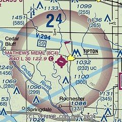
|
| Airport distance calculator |
|---|
|
|
| Sunrise and sunset |
|---|
|
Times for 09-Mar-2025
| | Local
(UTC-6) | | Zulu
(UTC) |
|---|
| Morning civil twilight | | 06:00 | | 12:00 |
| Sunrise | | 06:28 | | 12:28 |
| Sunset | | 18:03 | | 00:03 |
| Evening civil twilight | | 18:31 | | 00:31 |
|
| Current date and time |
|---|
| Zulu (UTC) | 10-Mar-2025 02:32:35 |
|---|
| Local (UTC-6) | 09-Mar-2025 20:32:35 |
|---|
|
| METAR |
|---|
KIOW
19nm SW | 100152Z AUTO 27004KT 10SM CLR 08/M03 A2992 RMK AO2 SLP136 T00831033 $
|
KMUT
24nm S | 100215Z AUTO 23004KT 10SM CLR 06/00 A2993 RMK AO2
|
KCID
26nm W | 100152Z 23007KT 10SM CLR 07/M01 A2989 RMK AO2 SLP126 T00721006
|
KDVN
27nm E | 100152Z AUTO 21007KT 10SM CLR 11/M01 A2992 RMK AO2 SLP133 T01111011
|
KMXO
27nm N | 100215Z AUTO 00000KT 10SM CLR 06/02 A2988 RMK AO2
|
KMLI
34nm SE | 100152Z 23005KT 10SM CLR 09/M01 A2990 RMK AO2 SLP128 T00941011
|
KCWI
38nm E | 100156Z AUTO 21006KT 10SM CLR 06/00 A2990 RMK AO2 SLP133 T00610000
|
KAWG
38nm SW | 100215Z AUTO 22006KT 10SM CLR 06/M01 A2991 RMK AO2
|
|
| TAF |
|---|
KCID
26nm W | 091720Z 0918/1018 24011G20KT P6SM SCT250 FM092000 24015G23KT P6SM SCT250 FM100000 24006KT P6SM SCT250 FM101500 22008KT P6SM SKC
|
|
| NOTAMs |
|---|
NOTAMs are issued by the DoD/FAA and will open in a separate window not controlled by AirNav.
|
|


