FAA INFORMATION EFFECTIVE 17 APRIL 2025
Location
| FAA Identifier: | D25 |
| Lat/Long: | 46-07-12.8174N 089-52-55.9199W
46-07.213623N 089-52.931998W
46.1202271,-89.8822000
(estimated) |
| Elevation: | 1610.3 ft. / 490.8 m (surveyed) |
| Variation: | 01W (1995) |
| From city: | 1 mile S of MANITOWISH WATERS, WI |
| Time zone: | UTC -5 (UTC -6 during Standard Time) |
| Zip code: | 54545 |
Airport Operations
| Airport use: | Open to the public |
| Activation date: | 10/1945 |
| Control tower: | no |
| ARTCC: | MINNEAPOLIS CENTER |
| FSS: | GREEN BAY FLIGHT SERVICE STATION |
| NOTAMs facility: | GRB (NOTAM-D service available) |
| Attendance: | UNATNDD |
| Wind indicator: | lighted |
| Segmented circle: | yes |
| Lights: | MIRL RWY 14/32 PRESET TO LOW SS-SR; TO INCR INTST & ACTVT REIL RWY 14 & 32; PAPI RWY 14 & 32; MIRL RWY 14/32 - CTAF. |
| Beacon: | white-green (lighted land airport)
Operates sunset to sunrise. |
Airport Communications
| CTAF/UNICOM: | 122.8 |
| WX AWOS-3PT: | 118.175 (715-543-2004) |
| WX AWOS-3 at ARV (13 nm SE): | 121.125 (715-356-2417) |
- APCH/DEP SVC PRVDD BY MINNEAPOLIS ARTCC ON FREQS 133.65/281.5 (RHINELANDER RCAG).
Nearby radio navigation aids
| VOR radial/distance | | VOR name | | Freq | | Var |
|---|
| IWDr157/26.7 | | IRONWOOD VOR/DME | | 108.80 | | 01E |
| RHIr327/34.1 | | RHINELANDER VOR/DME | | 115.05 | | 02E |
Airport Services
| Fuel available: | 100LL
100LL:24 HR SELF SVC FUEL AVBL WITH CREDIT CARD. |
| Parking: | tiedowns |
| Airframe service: | NONE |
| Powerplant service: | NONE |
Runway Information
Runway 14/32
| Dimensions: | 3498 x 60 ft. / 1066 x 18 m |
| Surface: | asphalt, in excellent condition |
| Weight bearing capacity: | |
| Runway edge lights: | medium intensity |
| RUNWAY 14 | | RUNWAY 32 |
| Latitude: | 46-07.520157N | | 46-07.071262N |
| Longitude: | 089-53.313783W | | 089-52.796012W |
| Elevation: | 1609.6 ft. | | 1610.2 ft. |
| Traffic pattern: | left | | left |
| Runway heading: | 142 magnetic, 141 true | | 322 magnetic, 321 true |
| Markings: | nonprecision, in good condition | | nonprecision, in good condition |
| Visual slope indicator: | 2-light PAPI on left (3.50 degrees glide path) | | 2-light PAPI on left (3.50 degrees glide path) |
| Runway end identifier lights: | yes | | yes |
| Touchdown point: | yes, no lights | | yes, no lights |
| Obstructions: | none | | 70 ft. trees, 1575 ft. from runway, 50 ft. left of centerline, 19:1 slope to clear |
Runway 4/22
| Dimensions: | 3094 x 120 ft. / 943 x 37 m |
| Surface: | turf, in good condition |
| Runway edge markings: | MKD WITH YELLOW CONES. |
| Operational restrictions: | CLSD IN WINTER. |
| RUNWAY 4 | | RUNWAY 22 |
| Latitude: | 46-06.934983N | | 46-07.306652N |
| Longitude: | 089-53.043145W | | 089-52.542955W |
| Elevation: | 1607.6 ft. | | 1609.8 ft. |
| Traffic pattern: | left | | left |
| Runway heading: | 044 magnetic, 043 true | | 224 magnetic, 223 true |
| Markings: | none | | none |
| Runway end identifier lights: | no | | no |
| Touchdown point: | yes, no lights | | yes, no lights |
| Obstructions: | 45 ft. trees, 450 ft. from runway, 80 ft. left of centerline, 10:1 slope to clear | | 85 ft. trees, 1120 ft. from runway, 200 ft. left of centerline, 13:1 slope to clear |
Airport Ownership and Management from official FAA records
| Ownership: | Publicly-owned |
| Owner: | TOWN OF MANITOWISH WATERS
P O BOX 267
MANITOWISH WATERS, WI 54545
Phone 715-543-8400 |
| Manager: | JOHN HANSON
P.O. BOX 267
MANITOWISH WATERS, WI 54545
Phone 715-904-0502 |
Additional Remarks
| - | 122 FT AGL/1737 FT MSL TWR APRXLY 1000 FT E OF ARPT. |
| - | DEER & COYOTES ON & INVOF ARPT. |
| - | BIRDS AND MIGRATORY WATERFOWL ON & INVOF ARPT. |
| - | FOR CD CTC MINNEAPOLIS ARTCC AT 651-463-5588. |
Instrument Procedures
NOTE: All procedures below are presented as PDF files. If you need a reader for these files, you should download the free Adobe Reader.NOT FOR NAVIGATION. Please procure official charts for flight.
FAA instrument procedures published for use from 17 April 2025 at 0901Z to 15 May 2025 at 0900z.
IAPs - Instrument Approach Procedures |
|---|
| RNAV (GPS) RWY 14 | |
download (216KB) |
| RNAV (GPS) RWY 32 | |
download (248KB) |
| NOTE: Special Take-Off Minimums/Departure Procedures apply | |
download (201KB) |
Other nearby airports with instrument procedures:
KARV - Lakeland Airport/Noble F. Lee Memorial Field (13 nm SE)
KPKF - Park Falls Municipal Airport (25 nm SW)
KIWD - Gogebic/Iron County Airport (27 nm NW)
KLNL - Kings Land O' Lakes Airport (28 nm E)
KEGV - Eagle River Union Airport (28 nm SE)
|
|

Road maps at:
MapQuest
Bing
Google
| Aerial photo |
|---|
WARNING: Photo may not be current or correct
 Photo by Lee Ward, co-pilot Frank Zsohar
Photo taken 12-May-2007
Photo by Lee Ward, co-pilot Frank Zsohar
Photo taken 12-May-2007
Do you have a better or more recent aerial photo of Manitowish Waters Airport that you would like to share? If so, please send us your photo.
|
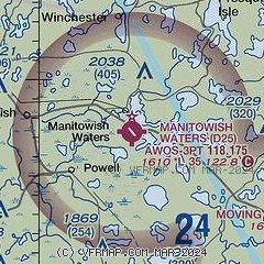
| Sectional chart |
|---|
|
| Airport distance calculator |
|---|
|
|
| Sunrise and sunset |
|---|
|
Times for 22-Apr-2025
| | Local
(UTC-5) | | Zulu
(UTC) |
|---|
| Morning civil twilight | | 05:30 | | 10:30 |
| Sunrise | | 06:02 | | 11:02 |
| Sunset | | 19:54 | | 00:54 |
| Evening civil twilight | | 20:27 | | 01:27 |
|
| Current date and time |
|---|
| Zulu (UTC) | 22-Apr-2025 20:29:17 |
|---|
| Local (UTC-5) | 22-Apr-2025 15:29:17 |
|---|
|
| METAR |
|---|
| KD25 | 222015Z AUTO 10003KT 10SM OVC036 07/02 A2999 RMK AO2 T00730019
|
KARV
14nm SE | 222015Z AUTO 10003KT 10SM OVC034 07/04 A2999 RMK AO2 T00720040
|
|
| TAF |
|---|
KIWD
26nm N | 221720Z 2218/2318 15008KT P6SM BKN060 TEMPO 2218/2219 -SHRA OVC040 FM221900 15008KT P6SM BKN045 TEMPO 2219/2221 -SHRA OVC025 FM222100 14008KT P6SM BKN022 FM222300 16008KT P6SM BKN020 FM230100 17006KT P6SM SCT035 FM231200 19007KT P6SM BKN090 PROB30 2312/2314 4SM -SHRA OVC040
|
|
| NOTAMs |
|---|
NOTAMs are issued by the DoD/FAA and will open in a separate window not controlled by AirNav.
|
|


