FAA INFORMATION EFFECTIVE 20 FEBRUARY 2025
Location
| FAA Identifier: | E11 |
| Lat/Long: | 32-19-50.7107N 102-31-46.8742W
32-19.845178N 102-31.781237W
32.3307530,-102.5296873
(estimated) |
| Elevation: | 3174 ft. / 967.4 m (surveyed) |
| Variation: | 09E (1990) |
| From city: | 1 mile NE of ANDREWS, TX |
| Time zone: | UTC -6 (UTC -5 during Daylight Saving Time) |
| Zip code: | 79714 |
Airport Operations
| Airport use: | Open to the public |
| Activation date: | 04/1948 |
| Control tower: | no |
| ARTCC: | FORT WORTH CENTER |
| FSS: | SAN ANGELO FLIGHT SERVICE STATION |
| NOTAMs facility: | SJT (NOTAM-D service available) |
| Attendance: | MON-FRI 0800-1700 |
| Wind indicator: | lighted |
| Segmented circle: | yes |
| Lights: | ACTVT REIL RWYS 16 & 34; PAPI RWYS 02 & 20; MIRL RWYS 02/20 & 16/34 - CTAF. |
| Beacon: | white-green (lighted land airport)
Operates sunset to sunrise. |
Airport Communications
| CTAF/UNICOM: | 122.8 |
| WX AWOS-3: | 118.2 (432-524-2471) |
| MIDLAND APPROACH: | 124.6 [0600-0000] |
| MIDLAND DEPARTURE: | 124.6 [0600-0000] |
- APCH/DEP CTL SVC PRVDD BY FORT WORTH ARTCC (ZFW) ON FREQS 133.1/298.95 (MIDLAND/A RCAG) WHEN MIDLAND APCH CTL (MAF) CLSD.
Nearby radio navigation aids
| VOR radial/distance | | VOR name | | Freq | | Var |
|---|
| MAFr307/25.9 | | MIDLAND VORTAC | | 112.60 | | 11E |
Airport Services
| Fuel available: | 100LL JET-A |
| Parking: | tiedowns |
| Airframe service: | MINOR |
| Powerplant service: | MINOR |
Runway Information
Runway 16/34
| Dimensions: | 5816 x 75 ft. / 1773 x 23 m |
| Surface: | asphalt, in excellent condition |
| Weight bearing capacity: | | Single wheel: | 23.0 | | Double wheel: | 37.0 |
|
| Runway edge lights: | medium intensity |
| RUNWAY 16 | | RUNWAY 34 |
| Latitude: | 32-20.406982N | | 32-19.482990N |
| Longitude: | 102-32.036033W | | 102-31.733652W |
| Elevation: | 3174.0 ft. | | 3167.9 ft. |
| Traffic pattern: | left | | right |
| Runway heading: | 155 magnetic, 164 true | | 335 magnetic, 344 true |
| Markings: | nonprecision, in good condition | | nonprecision, in good condition |
| Visual slope indicator: | 4-light PAPI on left (3.00 degrees glide path) | | 4-light PAPI on left (3.00 degrees glide path) |
| Runway end identifier lights: | yes | | yes |
| Touchdown point: | yes, no lights | | yes, no lights |
| Obstructions: | 64 ft. tree, 1200 ft. from runway, 542 ft. right of centerline, 15:1 slope to clear | | 46 ft. trees, 1190 ft. from runway, 126 ft. left and right of centerline, 21:1 slope to clear |
Runway 2/20
| Dimensions: | 3893 x 75 ft. / 1187 x 23 m |
| Surface: | asphalt, in fair condition |
| Weight bearing capacity: | |
| Runway edge lights: | medium intensity |
| RUNWAY 2 | | RUNWAY 20 |
| Latitude: | 32-19.504370N | | 32-20.079872N |
| Longitude: | 102-31.948832W | | 102-31.613917W |
| Elevation: | 3165.5 ft. | | 3168.3 ft. |
| Traffic pattern: | right | | left |
| Runway heading: | 017 magnetic, 026 true | | 197 magnetic, 206 true |
| Displaced threshold: | 954 ft. | | no |
| Markings: | basic, in good condition | | basic, in good condition |
| Visual slope indicator: | 2-light PAPI on left (3.00 degrees glide path) | | 2-light PAPI on left (3.00 degrees glide path) |
| Touchdown point: | yes, no lights | | yes, no lights |
| Obstructions: | 55 ft. trees, 285 ft. from runway, 138 ft. left of centerline, 1:1 slope to clear
2 FT. POSTS/CABLE FENCE. | | 10 ft. gnd, 514 ft. from runway, 125 ft. left and right of centerline, 31:1 slope to clear |
Runway 11/29
| Dimensions: | 3048 x 75 ft. / 929 x 23 m |
| Surface: | asphalt, in fair condition |
| Weight bearing capacity: | |
| RUNWAY 11 | | RUNWAY 29 |
| Latitude: | 32-19.857557N | | 32-19.587445N |
| Longitude: | 102-31.832937W | | 102-31.333795W |
| Elevation: | 3165.9 ft. | | 3157.7 ft. |
| Traffic pattern: | left | | right |
| Runway heading: | 114 magnetic, 123 true | | 294 magnetic, 303 true |
| Markings: | basic, in good condition | | basic, in good condition |
| Touchdown point: | yes, no lights | | yes, no lights |
| Obstructions: | 55 ft. trees, 940 ft. from runway, 130 ft. right of centerline, 13:1 slope to clear | | 45 ft. pole, 1830 ft. from runway, 125 ft. left of centerline, 36:1 slope to clear |
Helipad H1
| Dimensions: | 25 x 25 ft. / 8 x 8 m |
| Surface: | asphalt, in good condition |
| Latitude: | 32-19.550000N | | |
| Longitude: | 102-31.866667W | | |
| Elevation: | 3174.0 ft. | | |
| Traffic pattern: | left | | left |
| Markings: | none, in fair condition | | |
Airport Ownership and Management from official FAA records
| Ownership: | Publicly-owned |
| Owner: | ANDREWS COUNTY
201 N. MAIN
ANDREWS, TX 79714
Phone 432-524-1401 |
| Manager: | ROBERT VARGAS
853 E. BROADWAY
ANDREWS, TX 79714
Phone 432-524-1447 |
Additional Remarks
| A52-H1 | 60 FT RTG BCN 172 FT EAST (80 DEG). |
| - | FOR CD CTC MIDLAND APCH AT 432-563-2123. WHEN APCH CLSD CTC FORT WORTH ARTCC AT 817-858-7584. |
Instrument Procedures
NOTE: All procedures below are presented as PDF files. If you need a reader for these files, you should download the free Adobe Reader.NOT FOR NAVIGATION. Please procure official charts for flight.
FAA instrument procedures published for use from 20 February 2025 at 0901Z to 20 March 2025 at 0900Z.
IAPs - Instrument Approach Procedures |
|---|
| RNAV (GPS) RWY 16 | |
download (236KB) |
| NOTE: Special Alternate Minimums apply | |
download (117KB) |
| NOTE: Special Take-Off Minimums/Departure Procedures apply | |
download (113KB) |
Other nearby airports with instrument procedures:
KGNC - Gaines County Airport (22 nm N)
KODO - Odessa Airport-Schlemeyer Field (26 nm S)
KMDD - Midland Airpark (28 nm SE)
KMAF - Midland International Air and Space Port Airport (29 nm SE)
KLUV - Lamesa Municipal Airport (40 nm NE)
|
|

Road maps at:
MapQuest
Bing
Google
| Aerial photo |
|---|
WARNING: Photo may not be current or correct

Do you have a better or more recent aerial photo of Andrews County Airport that you would like to share? If so, please send us your photo.
|
| Sectional chart |
|---|
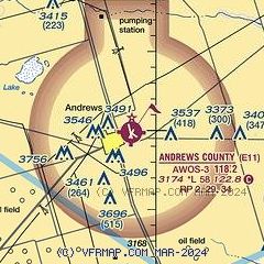
|
| Airport distance calculator |
|---|
|
|
| Sunrise and sunset |
|---|
|
Times for 14-Mar-2025
| | Local
(UTC-6) | | Zulu
(UTC) |
|---|
| Morning civil twilight | | 06:38 | | 12:38 |
| Sunrise | | 07:03 | | 13:03 |
| Sunset | | 18:56 | | 00:56 |
| Evening civil twilight | | 19:21 | | 01:21 |
|
| Current date and time |
|---|
| Zulu (UTC) | 14-Mar-2025 15:39:37 |
|---|
| Local (UTC-6) | 14-Mar-2025 09:39:37 |
|---|
|
| METAR |
|---|
| KE11 | 141455Z AUTO 27030G38KT 7SM CLR 12/M03 A2971 RMK AO2 T01161029
|
|
| TAF |
|---|
KMAF
28nm SE | 141120Z 1412/1512 25018G26KT P6SM SKC FM141400 26037G47KT 3SM BLDU SKC FM150100 27020G28KT P6SM SCT200
|
|
| NOTAMs |
|---|
NOTAMs are issued by the DoD/FAA and will open in a separate window not controlled by AirNav.
|
|


