FAA INFORMATION EFFECTIVE 17 APRIL 2025
Location
| FAA Identifier: | GNC |
| Lat/Long: | 32-40-31.2000N 102-39-09.6000W
32-40.520000N 102-39.160000W
32.6753333,-102.6526667
(estimated) |
| Elevation: | 3314.9 ft. / 1010.4 m (surveyed) |
| Variation: | 09E (2000) |
| From city: | 3 miles S of SEMINOLE, TX |
| Time zone: | UTC -5 (UTC -6 during Standard Time) |
| Zip code: | 79360 |
Airport Operations
| Airport use: | Open to the public |
| Activation date: | 12/1978 |
| Control tower: | no |
| ARTCC: | FORT WORTH CENTER |
| FSS: | FORT WORTH FLIGHT SERVICE STATION |
| NOTAMs facility: | GNC (NOTAM-D service available) |
| Attendance: | MON-FRI 0800-1800, ALL SAT 0800-1200
AFT HRS SVC: EMAIL JONATHAN OR CALL 432-955-7672. |
| Wind indicator: | lighted |
| Segmented circle: | yes |
| Lights: | MIRL RWYS 08/26 & 17/35 PRESET LOW INTST; TO INCR INTST ACTVT - CTAF. |
| Beacon: | white-green (lighted land airport)
Operates sunset to sunrise. |
Airport Communications
| CTAF/UNICOM: | 122.8 |
| WX AWOS-3: | 118.075 (432-758-3102) |
- APCH/DEP CTL SVC PRVDD BY FORT WORTH ARTCC (ZFW) ON FREQS 132.6/269.05 (LUBBOCK RCAG).
Nearby radio navigation aids
| VOR radial/distance | | VOR name | | Freq | | Var |
|---|
| HOBr075/31.2 | | HOBBS VORTAC | | 111.00 | | 11E |
Airport Services
| Fuel available: | 100LL JET-A |
| Parking: | hangars and tiedowns |
| Airframe service: | MAJOR |
| Powerplant service: | MAJOR |
| Bottled oxygen: | HIGH |
| Bulk oxygen: | HIGH |
Runway Information
Runway 8/26
| Dimensions: | 5381 x 75 ft. / 1640 x 23 m |
| Surface: | asphalt, in fair condition |
| Weight bearing capacity: | |
| Runway edge lights: | medium intensity |
| Runway edge markings: | RWY MRKGS FADED. |
| RUNWAY 8 | | RUNWAY 26 |
| Latitude: | 32-40.711768N | | 32-40.716218N |
| Longitude: | 102-39.918712W | | 102-38.869695W |
| Elevation: | 3313.1 ft. | | 3282.5 ft. |
| Traffic pattern: | left | | left |
| Runway heading: | 081 magnetic, 090 true | | 261 magnetic, 270 true |
| Markings: | basic, in poor condition | | basic, in poor condition |
| Visual slope indicator: | 2-light PAPI on left (3.00 degrees glide path) | | 2-light PAPI on left (3.00 degrees glide path) |
| Touchdown point: | yes, no lights | | yes, no lights |
| Obstructions: | none | | 30 ft. pline, marked, 848 ft. from runway, 21:1 slope to clear |
Runway 17/35
| Dimensions: | 5002 x 75 ft. / 1525 x 23 m |
| Surface: | asphalt, in good condition |
| Weight bearing capacity: | |
| Runway edge lights: | medium intensity |
| RUNWAY 17 | | RUNWAY 35 |
| Latitude: | 32-40.723990N | | 32-39.899227N |
| Longitude: | 102-38.912340W | | 102-38.901672W |
| Elevation: | 3283.7 ft. | | 3265.0 ft. |
| Traffic pattern: | left | | left |
| Runway heading: | 170 magnetic, 179 true | | 350 magnetic, 359 true |
| Markings: | nonprecision, in fair condition | | nonprecision, in fair condition |
| Visual slope indicator: | 2-light PAPI on left (3.00 degrees glide path) | | 2-light PAPI on left (3.00 degrees glide path) |
| Touchdown point: | yes, no lights | | yes, no lights |
| Obstructions: | 30 ft. pline, 1200 ft. from runway, 265 ft. left and right of centerline, 33:1 slope to clear
169 FT ANT 410 FT RIGHT OF CNTRLN. | | none |
Airport Ownership and Management from official FAA records
| Ownership: | Publicly-owned |
| Owner: | GAINES COUNTY
GAINES COUNTY COURTHOUSE
SEMINOLE, TX 79360
Phone 432-758-5411 |
| Manager: | DAVID MURPHREE
P O BOX 847
SEMINOLE, TX 79360
Phone 432-788-7657
COUNTY COMMISSIONER |
Additional Remarks
| - | FOR CD CTC FORT WORTH ARTCC AT 817-858-7584. |
| - | (CONTACT PHONE NR) JONATHAN@FLYTEXAVIATION.COM |
Instrument Procedures
NOTE: All procedures below are presented as PDF files. If you need a reader for these files, you should download the free Adobe Reader.NOT FOR NAVIGATION. Please procure official charts for flight.
FAA instrument procedures published for use from 17 April 2025 at 0901Z to 15 May 2025 at 0900z.
IAPs - Instrument Approach Procedures |
|---|
| RNAV (GPS) RWY 35 | |
download (276KB) |
| NOTE: Special Alternate Minimums apply | |
download (16KB) |
| NOTE: Special Take-Off Minimums/Departure Procedures apply | |
download (113KB) |
Other nearby airports with instrument procedures:
E11 - Andrews County Airport (22 nm S)
KHOB - Lea County Regional Airport (29 nm W)
F98 - Yoakum County Airport (34 nm N)
KLUV - Lamesa Municipal Airport (37 nm E)
KBFE - Terry County Airport (38 nm NE)
|
|

Road maps at:
MapQuest
Bing
Google
| Aerial photo |
|---|

|
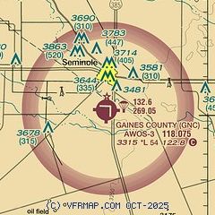
| Sectional chart |
|---|
|
| Airport distance calculator |
|---|
|
|
| Sunrise and sunset |
|---|
|
Times for 23-Apr-2025
| | Local
(UTC-5) | | Zulu
(UTC) |
|---|
| Morning civil twilight | | 06:47 | | 11:47 |
| Sunrise | | 07:13 | | 12:13 |
| Sunset | | 20:25 | | 01:25 |
| Evening civil twilight | | 20:51 | | 01:51 |
|
| Current date and time |
|---|
| Zulu (UTC) | 23-Apr-2025 11:16:37 |
|---|
| Local (UTC-5) | 23-Apr-2025 06:16:37 |
|---|
|
| METAR |
|---|
| KGNC | 231055Z AUTO 10008KT 10SM OVC022 17/08 A2999 RMK AO2 T01670078
|
|
| TAF |
|---|
KHOB
28nm W | 231002Z 2310/2406 12014G20KT P6SM OVC017 FM231700 15010KT P6SM SCT060 SCT200
|
|
| NOTAMs |
|---|
NOTAMs are issued by the DoD/FAA and will open in a separate window not controlled by AirNav.
|
|


