FAA INFORMATION EFFECTIVE 20 FEBRUARY 2025
Location
| FAA Identifier: | K15 |
| Lat/Long: | 38-06-37.6000N 092-40-50.0000W
38-06.626667N 092-40.833333W
38.1104444,-92.6805556
(estimated) |
| Elevation: | 876.3 ft. / 267.1 m (surveyed) |
| Variation: | 02E (2000) |
| From city: | 1 mile SW of OSAGE BEACH, MO |
| Time zone: | UTC -6 (UTC -5 during Daylight Saving Time) |
| Zip code: | 65065 |
Airport Operations
| Airport use: | Open to the public |
| Activation date: | 10/1947 |
| Control tower: | no |
| ARTCC: | KANSAS CITY CENTER |
| FSS: | COLUMBIA FLIGHT SERVICE STATION |
| NOTAMs facility: | COU (NOTAM-D service available) |
| Attendance: | APR-SEP SAT-THU 0800-1800, APR-SEP FRI 0800-2000, OCT-MAR 0800-1800 |
| Wind indicator: | lighted |
| Segmented circle: | no |
| Lights: | ACTVT PAPI RWY 32; MIRL RWY 14/32 - CTAF. |
| Beacon: | white-green (lighted land airport)
Operates sunset to sunrise. |
Airport Communications
| CTAF/UNICOM: | 122.8 |
| MIZZU APPROACH: | 124.1 [OPR 1300-0500Z++ MON-FRI; 1400-2300Z++ SAT-SUN; CLSD HOL.] |
| MIZZU DEPARTURE: | 124.1 [OPR 1300-0500Z++ MON-FRI; 1400-2300Z++ SAT-SUN; CLSD HOL.] |
| WX AWOS-3PT at AIZ (6 nm E): | 135.325 (573-348-0847) |
| WX AWOS-3PT at OZS (8 nm S): | 120.225 (573-233-1004) |
Nearby radio navigation aids
| VOR radial/distance | | VOR name | | Freq | | Var |
|---|
| SHYr319/5.6 | | SUNSHINE VOR/DME | | 108.40 | | 00E |
| TBNr311/(33.8) | | FORNEY VOR | | 110.00 | | 00E |
Airport Services
| Fuel available: | 100LL JET-A |
| Parking: | hangars and tiedowns |
| Bottled oxygen: | NONE |
| Bulk oxygen: | NONE |
Runway Information
Runway 14/32
| Dimensions: | 3205 x 60 ft. / 977 x 18 m |
| Surface: | asphalt/aggregate friction seal coat, in good condition |
| Weight bearing capacity: | |
| Runway edge lights: | medium intensity |
| Operational restrictions: | RESTRICTED TO ACFT 12,500 LBS MAX GWT OR LESS; PPR FOR ACFT EXCEEDING 12,500 LBS CALL AMGR ON 573-302-2003. |
| RUNWAY 14 | | RUNWAY 32 |
| Latitude: | 38-06.835593N | | 38-06.417638N |
| Longitude: | 092-41.037705W | | 092-40.629328W |
| Elevation: | 876.3 ft. | | 857.5 ft. |
| Traffic pattern: | left | | left |
| Runway heading: | 140 magnetic, 142 true | | 320 magnetic, 322 true |
| Markings: | nonprecision, in good condition | | nonprecision, in good condition |
| Visual slope indicator: | | | 4-light PAPI on left (3.50 degrees glide path) |
| Touchdown point: | yes, no lights | | yes, no lights |
| Obstructions: | 20 ft. pline, marked, 447 ft. from runway, 290 ft. left and right of centerline, 12:1 slope to clear | | 34 ft. trees, 330 ft. from runway, 250 ft. left and right of centerline, 3:1 slope to clear
BRUSH AND SMALL TREES 10-12 FT TALL, 60-80 FT FROM RWY END, 50 - 70L |
Airport Ownership and Management from official FAA records
| Ownership: | Publicly-owned |
| Owner: | CITY OF OSAGE BEACH
1000 CITY PARKWAY
OSAGE BEACH, MO 65065
Phone 573-302-2000 |
| Manager: | TY DINSDALE
1000 CITY PARKWAY
OSAGE BEACH, MO 65065
Phone 573-348-4469 |
Additional Remarks
| - | DEER ON AND INVOF RY & TWYS DUSK AND AFT DARK. |
| - | FOR CD CTC MIZZOU APCH AT 417-868-5620/5619. |
Instrument Procedures
NOTE: All procedures below are presented as PDF files. If you need a reader for these files, you should download the free Adobe Reader.NOT FOR NAVIGATION. Please procure official charts for flight.
FAA instrument procedures published for use from 20 February 2025 at 0901Z to 20 March 2025 at 0900Z.
IAPs - Instrument Approach Procedures |
|---|
| RNAV (GPS) RWY 14 | |
download (246KB) |
| RNAV (GPS) RWY 32 | |
download (263KB) |
| VOR RWY 32 | |
download (249KB) |
| NOTE: Special Take-Off Minimums/Departure Procedures apply | |
download (158KB) |
Other nearby airports with instrument procedures:
KAIZ - Lee C Fine Memorial Airport (6 nm E)
KOZS - Camdenton Memorial-Lake Regional Airport (8 nm S)
H79 - Eldon Model Airpark (16 nm N)
KLBO - Floyd W Jones Lebanon Airport (28 nm S)
KTBN - Waynesville-St. Robert Regional Airport-Forney Field (34 nm SE)
|
|

Road maps at:
MapQuest
Bing
Google
| Aerial photo |
|---|
WARNING: Photo may not be current or correct
 Photo by Eve Cascella
Photo taken 24-Aug-2008
from the south looking north
Photo by Eve Cascella
Photo taken 24-Aug-2008
from the south looking north
Do you have a better or more recent aerial photo of Grand Glaize-Osage Beach Airport that you would like to share? If so, please send us your photo.
|
| Sectional chart |
|---|
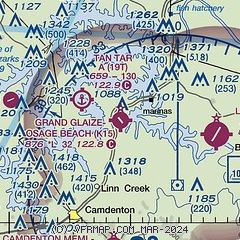
|
| Airport distance calculator |
|---|
|
|
| Sunrise and sunset |
|---|
|
Times for 12-Mar-2025
| | Local
(UTC-6) | | Zulu
(UTC) |
|---|
| Morning civil twilight | | 06:01 | | 12:01 |
| Sunrise | | 06:27 | | 12:27 |
| Sunset | | 18:14 | | 00:14 |
| Evening civil twilight | | 18:40 | | 00:40 |
|
| Current date and time |
|---|
| Zulu (UTC) | 13-Mar-2025 00:54:28 |
|---|
| Local (UTC-6) | 12-Mar-2025 18:54:28 |
|---|
|
| METAR |
|---|
KAIZ
7nm E | 122356Z AUTO 18005KT 10SM CLR 24/04 A2967 RMK AO2 SLP040 6//// T02390039 10278 20239 53008
|
KOZS
8nm S | 130035Z AUTO 17003KT 10SM CLR 22/02 A2968 RMK AO2
|
|
| TAF |
|---|
KTBN
36nm SE | 122100Z 1221/1403 VRB06KT 9999 SKC QNH2957INS BECMG 1223/1301 VRB06KT 9999 FEW005 BKN030 BKN150 QNH2959INS BECMG 1400/1402 16010G15KT 9999 SCT250 QNH2970INS TX29/1321Z TN12/1312Z LAST NO AMDS AFT 1303 NEXT 1313
|
KJEF
39nm NE | 121720Z 1218/1318 VRB04KT P6SM SCT250
|
|
| NOTAMs |
|---|
NOTAMs are issued by the DoD/FAA and will open in a separate window not controlled by AirNav.
|
|


