FAA INFORMATION EFFECTIVE 23 JANUARY 2025
Location
| FAA Identifier: | ACP |
| Lat/Long: | 30-45-01.8310N 092-41-18.5670W
30-45.030517N 092-41.309450W
30.7505086,-92.6884908
(estimated) |
| Elevation: | 107.1 ft. / 32.6 m (surveyed) |
| Variation: | 03E (1995) |
| From city: | 4 miles S of OAKDALE, LA |
| Time zone: | UTC -6 (UTC -5 during Daylight Saving Time) |
| Zip code: | 71463 |
Airport Operations
| Airport use: | Open to the public |
| Activation date: | 12/1968 |
| Control tower: | no |
| ARTCC: | HOUSTON CENTER |
| FSS: | DE RIDDER FLIGHT SERVICE STATION |
| NOTAMs facility: | DRI (NOTAM-D service available) |
| Attendance: | CONTINUOUS |
| Wind indicator: | lighted |
| Segmented circle: | no |
| Lights: | MIRL RY 18/36 & REIL RYS 18 & 36 PRESET LOW INTST DUSK-DAWN; TO INCR INTST ACTVT - CTAF. |
| Beacon: | white-green (lighted land airport)
Operates sunset to sunrise. |
Airport Communications
| CTAF/UNICOM: | 122.8 |
| WX AWOS-3PT: | 118.275 (318-215-9728) |
| POLK APPROACH: | 123.7 |
| POLK DEPARTURE: | 123.7 |
Nearby radio navigation aids
| VOR radial/distance | | VOR name | | Freq | | Var |
|---|
| AEXr195/31.9 | | ALEXANDRIA VORTAC | | 116.10 | | 03E |
| FXUr126/(34.9) | | POLK VOR | | 108.40 | | 02E |
| NDB name | | Hdg/Dist | | Freq | | Var | | ID |
|---|
| DE RIDDER | | 086/33.3 | | 385 | | 04E | | DXB | -.. -..- -... |
Airport Services
| Fuel available: | 100LL JET-A
100LL:FUEL AVBL SELF SERVICE WITH CREDIT CARD.
A:FUEL AVBL SELF SERVICE WITH CREDIT CARD. |
| Parking: | hangars and tiedowns |
| Airframe service: | NONE |
| Powerplant service: | NONE |
| Bottled oxygen: | NONE |
| Bulk oxygen: | NONE |
Runway Information
Runway 18/36
| Dimensions: | 5000 x 75 ft. / 1524 x 23 m |
| Surface: | asphalt, in good condition |
| Weight bearing capacity: | |
| Runway edge lights: | medium intensity |
| RUNWAY 18 | | RUNWAY 36 |
| Latitude: | 30-45.442862N | | 30-44.618183N |
| Longitude: | 092-41.305578W | | 092-41.313332W |
| Elevation: | 101.4 ft. | | 107.1 ft. |
| Traffic pattern: | left | | left |
| Runway heading: | 177 magnetic, 180 true | | 357 magnetic, 360 true |
| Markings: | nonprecision, in good condition | | nonprecision, in good condition |
| Visual slope indicator: | 2-light PAPI on left (3.00 degrees glide path) | | 2-light PAPI on left (3.00 degrees glide path) |
| Runway end identifier lights: | yes | | yes |
| Touchdown point: | yes, no lights | | yes, no lights |
| Obstructions: | 58 ft. trees, 1380 ft. from runway, 333 ft. left of centerline, 20:1 slope to clear | | 45 ft. trees, 406 ft. from runway, 152 ft. right of centerline, 4:1 slope to clear |
Airport Ownership and Management from official FAA records
| Ownership: | Publicly-owned |
| Owner: | ALLEN PARISH POLICE JURY
P. O. DRAWER G
OBERLIN, LA 70655
Phone 337-639-4396 |
| Manager: | JOEL B JOHNSON
278 AIRPORT ROAD
OAKDALE, LA 71463
Phone 318-215-0090 |
Additional Remarks
| - | GCO AVBL ON FREQ 135.075 THRU POE APCH CTL & FLT SVCS. |
| - | STANDING WATER ON RUNWAY AT MIDFIELD AFTER RAIN. |
| - | FOR CD IF UNA VIA GCO, CTC POLK APCH AT 337-531-2352. |
Instrument Procedures
NOTE: All procedures below are presented as PDF files. If you need a reader for these files, you should download the free Adobe Reader.NOT FOR NAVIGATION. Please procure official charts for flight.
FAA instrument procedures published for use from 23 January 2025 at 0901Z to 20 February 2025 at 0900z.
IAPs - Instrument Approach Procedures |
|---|
| RNAV (GPS) RWY 18 | |
download (204KB) |
| RNAV (GPS) RWY 36 | |
download (196KB) |
| NOTE: Special Alternate Minimums apply | |
download (22KB) |
| NOTE: Special Take-Off Minimums/Departure Procedures apply | |
download (116KB) |
Other nearby airports with instrument procedures:
4R7 - Eunice Airport (22 nm SE)
2R6 - Bunkie Municipal Airport (26 nm NE)
3R7 - Jennings Airport (30 nm S)
KPOE - Maks Army Air Field (31 nm NW)
6R1 - Welsh Airport (31 nm S)
|
|

Road maps at:
MapQuest
Bing
Google
| Aerial photo |
|---|
WARNING: Photo may not be current or correct
 Photo by Danny R. Schnautz
Photo taken 19-Aug-2020
looking northwest.
Photo by Danny R. Schnautz
Photo taken 19-Aug-2020
looking northwest.
Do you have a better or more recent aerial photo of Allen Parish Airport that you would like to share? If so, please send us your photo.
|
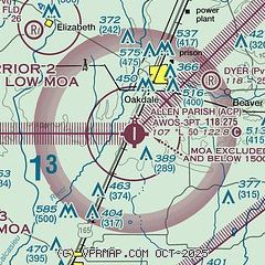
| Sectional chart |
|---|
|
| Airport distance calculator |
|---|
|
|
| Sunrise and sunset |
|---|
|
Times for 07-Feb-2025
| | Local
(UTC-6) | | Zulu
(UTC) |
|---|
| Morning civil twilight | | 06:34 | | 12:34 |
| Sunrise | | 06:59 | | 12:59 |
| Sunset | | 17:51 | | 23:51 |
| Evening civil twilight | | 18:16 | | 00:16 |
|
| Current date and time |
|---|
| Zulu (UTC) | 07-Feb-2025 17:47:49 |
|---|
| Local (UTC-6) | 07-Feb-2025 11:47:49 |
|---|
|
| METAR |
|---|
| KACP | 071735Z AUTO 18005KT 10SM SCT023 SCT029 24/17 A3015 RMK AO2
|
KBKB
20nm NW | 071649Z AUTO VRB03KT 10SM SCT017 SCT024 BKN037 23/18 A3013 RMK AO2 SLP228 T02280183
|
|
| TAF |
|---|
KPOE
28nm NW | 071459Z 0715/0821 18006KT 9999 SCT007 OVC015 QNH3011INS TEMPO 0715/0717 OVC007 BECMG 0716/0717 18007KT 9999 BKN010 QNH3010INS BECMG 0717/0718 20009KT 9999 BKN015 QNH3007INS BECMG 0719/0720 20009KT 9999 BKN020 QNH3005INS BECMG 0802/0803 20007KT 9999 BKN008 QNH3007INS BECMG 0805/0806 20007KT 9999 OVC005 QNH3002INS BECMG 0814/0815 20010G15KT 9999 BKN007 QNH3006INS BECMG 0816/0817 20012G20KT 9999 BKN010 QNH3002INS BECMG 0818/0819 20014G22KT 9999 BKN020 QNH2997INS TX26/0721Z TN19/0807Z
|
|
| NOTAMs |
|---|
NOTAMs are issued by the DoD/FAA and will open in a separate window not controlled by AirNav.
|
|


