FAA INFORMATION EFFECTIVE 17 APRIL 2025
Location
| FAA Identifier: | BVU |
| Lat/Long: | 35-56-50.3090N 114-51-39.9030W
35-56.838483N 114-51.665050W
35.9473081,-114.8610842
(estimated) |
| Elevation: | 2203.1 ft. / 671.5 m (surveyed) |
| Variation: | 11E (2020) |
| From city: | 1 mile SW of BOULDER CITY, NV |
| Time zone: | UTC -7 (UTC -8 during Standard Time) |
| Zip code: | 89005 |
Airport Operations
| Airport use: | Open to the public |
| Activation date: | 08/1990 |
| Control tower: | no |
| ARTCC: | LOS ANGELES CENTER |
| FSS: | RENO FLIGHT SERVICE STATION |
| NOTAMs facility: | RNO (NOTAM-D service available) |
| Attendance: | 0800-1700 |
| Wind indicator: | lighted |
| Segmented circle: | yes |
| Lights: | ACTVT MIRL RWY 09/27 & 15/33 - CTAF. |
| Beacon: | white-green (lighted land airport)
Operates sunset to sunrise. |
Airport Communications
| CTAF/UNICOM: | 122.7 |
| WX AWOS-3: | 118.475 (702-293-1532) |
| LAS VEGAS APPROACH: | 125.475 |
| WX AWOS-3PT at HND (13 nm W): | 120.775 (702-614-4537) |
| WX ASOS at LAS (16 nm NW): | PHONE 702-582-5334 |
Nearby radio navigation aids
| VOR radial/distance | | VOR name | | Freq | | Var |
|---|
| BLDr163/2.9 | | BOULDER CITY VORTAC | | 116.70 | | 15E |
| LASr104/16.5 | | LAS VEGAS VORTAC | | 116.90 | | 15E |
Airport Services
| Fuel available: | 100LL JET-A
A:SELF SVC JET-A AVBL 24/7 WITH CC.
100LL:SELF SVC 100LL AVBL 24/7 WITH CC. |
| Parking: | hangars and tiedowns |
| Airframe service: | MAJOR |
| Powerplant service: | MAJOR |
Runway Information
Runway 9/27
| Dimensions: | 5103 x 75 ft. / 1555 x 23 m |
| Surface: | asphalt, in good condition |
| Weight bearing capacity: | |
| Runway edge lights: | medium intensity |
| RUNWAY 9 | | RUNWAY 27 |
| Latitude: | 35-56.847610N | | 35-56.705500N |
| Longitude: | 114-52.141835W | | 114-51.122500W |
| Elevation: | 2108.4 ft. | | 2139.0 ft. |
| Traffic pattern: | right | | left |
| Runway heading: | 089 magnetic, 100 true | | 269 magnetic, 280 true |
| Displaced threshold: | no | | 300 ft. |
| Markings: | nonprecision, in good condition | | nonprecision, in good condition |
| Visual slope indicator: | 2-light PAPI on left (3.00 degrees glide path) | | 2-light PAPI on left (3.00 degrees glide path) |
| Runway end identifier lights: | yes | | yes |
| Touchdown point: | yes, no lights | | yes, no lights |
| Obstructions: | none | | 123 ft. pline, lighted, 3724 ft. from runway, 29:1 slope to clear |
Runway 15/33
| Dimensions: | 3852 x 75 ft. / 1174 x 23 m |
| Surface: | asphalt, in good condition |
| Weight bearing capacity: | |
| Runway edge lights: | medium intensity |
| RUNWAY 15 | | RUNWAY 33 |
| Latitude: | 35-57.227598N | | 35-56.613497N |
| Longitude: | 114-51.806773W | | 114-51.610493W |
| Elevation: | 2203.1 ft. | | 2098.7 ft. |
| Traffic pattern: | right | | left |
| Markings: | basic, in good condition | | basic, in good condition |
| Visual slope indicator: | | | 2-light PAPI on left (3.00 degrees glide path) |
| Runway end identifier lights: | yes | | yes |
| Touchdown point: | yes, no lights | | yes, no lights |
| Obstructions: | 10 ft. gnd, 400 ft. from runway, 20:1 slope to clear | | none |
Airport Ownership and Management from official FAA records
| Ownership: | Publicly-owned |
| Owner: | CITY OF BOULDER CITY
401 CALIFORNIA AVENUE
BOULDER CITY, NV 89005
Phone (702) 293-9405 |
| Manager: | MARISSA ADOU
1201 AIRPORT ROAD, SUITE 200
BOULDER CITY, NV 89005
Phone 702-293-9405
AIRPORT MANAGER EMAIL: AIRPORTADMIN@BCNV.ORG 702-293-9405 |
Additional Remarks
| - | RWY 33 STEEP RWY GRADIENT; RISING TERRAIN; OBSTACLES OFF DEP END OF RWY. |
| - | LARGE NUMBER OF GRAND CANYON TOUR ACFT OPERATIONS IN VICINITY TRANSITING TO & FROM AIRPORT. |
| - | HELICOPTERS CROSS ACTIVE RWYS AND TWYS. |
| - | RWY 27 PREFERRED UNDER LIGHT OR NO WIND CONDITIONS. |
| - | TAXIWAY SHOULDERS ADJ TO TWY D WEST OF RWY 15/33, SOFT GROUND AND DROPS OFF MORE THAN 3 INCHES. |
| - | OPERATIONS IN SOUTHERN NEVADA - UNMANNED AIRCRAFT SYSTEM ACTIVITY WITHIN AN AREA DEFINED AS 3NM RADIUS OF BLD R-197/7NM, SFC-400 FT AGL. |
| - | CTC AP OPS FOR RWY COND RPT, 702-293-9405, OR WHEN THE AP IS UNATNDD. |
| - | AVOID OVERFLIGHT OF BOULDER CITY RESIDENTIAL AREAS. |
| - | FOR ATC ASSISTANCE CALL OR CONTACT LAS VEGAS APCH AT 725-200-4432. |
| - | RWY 15/33 NO RUNUP AREA. RUNUP AREA LCTD ON TWY D AND TWY A. |
| - | UNLIGHTED POWER LINES ALL QUADRANTS. |
| - | UPHILL DEPARTURES ON RWY 33 NOT RECOMMENDED. |
| - | STEEP RISING TERRAIN NORTH OF ARPT. |
| - | ULTRALIGHT ACTIVITY 2 MILES SW OF ARPT INVOF DRY LAKE BED. |
| - | SKYDIVE DROP ZONE ADJACENT AIRPORT NORTH EAST SIDE. |
Instrument Procedures
NOTE: All procedures below are presented as PDF files. If you need a reader for these files, you should download the free Adobe Reader.NOT FOR NAVIGATION. Please procure official charts for flight.
FAA instrument procedures published for use from 17 April 2025 at 0901Z to 15 May 2025 at 0900z.
IAPs - Instrument Approach Procedures |
|---|
| RNAV (GPS) RWY 27 | |
download (257KB) |
| NOTE: Special Alternate Minimums apply | |
download (102KB) |
| NOTE: Special Take-Off Minimums/Departure Procedures apply | |
download (416KB) |
Other nearby airports with instrument procedures:
KHND - Henderson Executive Airport (13 nm W)
KLAS - Harry Reid International Airport (16 nm NW)
KLSV - Nellis Air Force Base (19 nm NW)
KVGT - North Las Vegas Airport (23 nm NW)
KIFP - Laughlin/Bullhead International Airport (50 nm S)
|
|

Road maps at:
MapQuest
Bing
Google
| Aerial photo |
|---|
WARNING: Photo may not be current or correct
 Photo by Troy Johnston
Photo taken 11-Aug-2017
looking northwest.
Photo by Troy Johnston
Photo taken 11-Aug-2017
looking northwest.
Do you have a better or more recent aerial photo of Boulder City Municipal Airport that you would like to share? If so, please send us your photo.
|
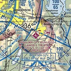
| Sectional chart |
|---|
|
| Airport distance calculator |
|---|
|
|
| Sunrise and sunset |
|---|
|
Times for 21-Apr-2025
| | Local
(UTC-7) | | Zulu
(UTC) |
|---|
| Morning civil twilight | | 05:33 | | 12:33 |
| Sunrise | | 06:00 | | 13:00 |
| Sunset | | 19:17 | | 02:17 |
| Evening civil twilight | | 19:44 | | 02:44 |
|
| Current date and time |
|---|
| Zulu (UTC) | 21-Apr-2025 15:56:03 |
|---|
| Local (UTC-7) | 21-Apr-2025 08:56:03 |
|---|
|
| METAR |
|---|
| KBVU | 211535Z AUTO 00000KT 10SM CLR 20/M12 A2996 RMK AO2
|
KHND
13nm W | 211456Z 22004KT 10SM CLR 18/M10 A3000 RMK AO2 SLP158 T01781100 51014 $
|
KLAS
16nm NW | 211456Z 32003KT 10SM SCT250 19/M10 A2999 RMK AO2 SLP136 T01891100 53015
|
KLSV
18nm NW | 211453Z 15002KT 10SM FEW220 17/M14 A2994 RMK SLP123 T01651141 52014
|
|
| TAF |
|---|
KHND
13nm W | 211120Z 2112/2212 22008KT P6SM BKN250 FM211500 VRB05KT P6SM BKN250 FM212200 23009KT P6SM BKN250 FM220400 18009KT P6SM SCT250
|
KLAS
16nm NW | 211120Z 2112/2218 VRB05KT P6SM BKN250 FM211900 12009KT P6SM BKN250 FM220000 23008KT P6SM SCT250 FM221300 VRB05KT P6SM FEW250
|
KLSV
18nm NW | 210700Z 2107/2213 08007KT 9999 SCT250 QNH2989INS BECMG 2121/2122 12010G15KT 9999 FEW250 QNH2975INS BECMG 2206/2207 16005KT 9999 FEW250 QNH2982INS TX30/2123Z TN13/2113Z
|
|
| NOTAMs |
|---|
NOTAMs are issued by the DoD/FAA and will open in a separate window not controlled by AirNav.
|
|


