FAA INFORMATION EFFECTIVE 17 APRIL 2025
Location
| FAA Identifier: | CNP |
| Lat/Long: | 41-04-38.9000N 102-27-50.6000W
41-04.648333N 102-27.843333W
41.0774722,-102.4640556
(estimated) |
| Elevation: | 3681.7 ft. / 1122 m (estimated) |
| Variation: | 10E (1990) |
| From city: | 1 mile S of CHAPPELL, NE |
| Time zone: | UTC -6 (UTC -7 during Standard Time) |
| Zip code: | 69129 |
Airport Operations
| Airport use: | Open to the public |
| Control tower: | no |
| ARTCC: | DENVER CENTER |
| FSS: | COLUMBUS FLIGHT SERVICE STATION |
| NOTAMs facility: | OLU (NOTAM-D service available) |
| Attendance: | UNATNDD |
| Wind indicator: | lighted |
| Segmented circle: | no |
| Lights: | MIRL RWY 12/30 PRESET LOW INTST; TO INCR INTST ACTVT - CTAF. |
| Beacon: | white-green (lighted land airport)
Operates sunset to sunrise. |
Airport Communications
- APCH/DEP CTL SVC PRVDD BY DENVER ARTCC (ZDV) ON FREQS 118.475/225.4 (BRUSH/B/ RCAG).
Nearby radio navigation aids
| VOR radial/distance | | VOR name | | Freq | | Var |
|---|
| SNYr080/23.5 | | SIDNEY VOR/DME | | 115.90 | | 13E |
| SAEr258/31.2 | | SEARLE VOR/DME | | 110.20 | | 07E |
| NDB name | | Hdg/Dist | | Freq | | Var | | ID |
|---|
| CHAPPELL | | at field | | 383 | | 10E | | CNP | -.-. -. .--. |
| OSHKOSH | | 186/20.1 | | 233 | | 09E | | OKS | --- -.- ... |
| GRANT | | 281/35.5 | | 359 | | 09E | | GGF | --. --. ..-. |
Airport Services
| Fuel available: | 100LL |
| Parking: | tiedowns |
| Airframe service: | NONE |
| Powerplant service: | NONE |
| Bottled oxygen: | NONE |
| Bulk oxygen: | NONE |
Runway Information
Runway 12/30
| Dimensions: | 4000 x 55 ft. / 1219 x 17 m |
| Surface: | asphalt, in poor condition
SEVERE BLOCK CRACKING AND FOD THRU OUT PVMNT. |
| Weight bearing capacity: | | PCN 72 /F/D/Z/T | | Single wheel: | 15.0 |
|
| Runway edge lights: | medium intensity |
| RUNWAY 12 | | RUNWAY 30 |
| Latitude: | 41-04.858517N | | 41-04.436817N |
| Longitude: | 102-28.177333W | | 102-27.508717W |
| Elevation: | 3681.3 ft. | | 3677.8 ft. |
| Traffic pattern: | left | | left |
| Runway heading: | 120 magnetic, 130 true | | 300 magnetic, 310 true |
| Displaced threshold: | no | | 130 ft. |
| Markings: | nonprecision, in fair condition | | nonprecision, in fair condition |
| Touchdown point: | yes, no lights | | yes, no lights |
| Obstructions: | 30 ft. road, 709 ft. from runway, 288 ft. right of centerline, 16:1 slope to clear | | 11 ft. road, 371 ft. from runway, 155 ft. right of centerline, 15:1 slope to clear
APCH SLOPE 45:1 TO DSPLCD THLD. |
Airport Ownership and Management from official FAA records
| Ownership: | Publicly-owned |
| Owner: | CHAPPELL AIRPORT AUTHORITY
PO BOX 546
CHAPPELL, NE 69129-0546
Phone 308-874-2708 |
| Manager: | CHRIS RAY
PO BOX 546
CHAPPELL, NE 69129-0546
Phone 308-874-4350 |
Additional Remarks
| - | FOR CD CTC DENVER ARTCC AT 303-651-4257. |
Instrument Procedures
NOTE: All procedures below are presented as PDF files. If you need a reader for these files, you should download the free Adobe Reader.NOT FOR NAVIGATION. Please procure official charts for flight.
FAA instrument procedures published for use from 17 April 2025 at 0901Z to 15 May 2025 at 0900z.
IAPs - Instrument Approach Procedures |
|---|
| NDB OR GPS RWY 30 | |
download (202KB) |
| NOTE: Special Take-Off Minimums/Departure Procedures apply | |
download (358KB) |
Other nearby airports with instrument procedures:
KOKS - Garden County Airport/King Rhiley Field (20 nm N)
KSNY - Sidney Municipal Airport/Lloyd W. Carr Field (24 nm W)
KOGA - Searle Field Airport (31 nm E)
KHEQ - Holyoke Airport (32 nm S)
KGGF - Grant Municipal Airport (35 nm E)
|
|

Road maps at:
MapQuest
Bing
Google
| Aerial photo |
|---|
WARNING: Photo may not be current or correct

Do you have a better or more recent aerial photo of Billy G Ray Field Airport that you would like to share? If so, please send us your photo.
|
| Sectional chart |
|---|
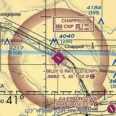
|
| Airport distance calculator |
|---|
|
|
| Sunrise and sunset |
|---|
|
Times for 27-Apr-2025
| | Local
(UTC-6) | | Zulu
(UTC) |
|---|
| Morning civil twilight | | 05:24 | | 11:24 |
| Sunrise | | 05:54 | | 11:54 |
| Sunset | | 19:41 | | 01:41 |
| Evening civil twilight | | 20:11 | | 02:11 |
|
| Current date and time |
|---|
| Zulu (UTC) | 27-Apr-2025 13:37:31 |
|---|
| Local (UTC-6) | 27-Apr-2025 07:37:31 |
|---|
|
| METAR |
|---|
KSNY
24nm W | 271213Z AUTO 16012G20KT 3SM HZ OVC003 12/01 A2979 RMK AO2 T01220006 $
|
KOGA
31nm E | 271315Z AUTO 15013G20KT 7SM OVC005 14/13 A2984 RMK AO2 T01350132
|
KHEQ
32nm S | 271315Z AUTO 15014KT 5SM BR SCT004 OVC008 13/12 A2982 RMK AO2
|
KGGF
35nm E | 271315Z AUTO 15017G23KT 2 1/2SM BR OVC003 13/13 A2984 RMK AO2
|
KSTK
46nm SW | 271315Z AUTO 12009KT 2 1/2SM BR OVC003 12/12 A2979 RMK AO2
|
|
| TAF |
|---|
KSNY
24nm W | 271136Z 2712/2812 16011KT 4SM BR OVC003 FM271600 17015G22KT P6SM SCT010 FM271900 16015G25KT P6SM SCT120 FM280000 17015G25KT P6SM VCTS BKN050CB FM280300 32015G25KT P6SM OVC120 FM280900 30008KT P6SM BKN120
|
|
| NOTAMs |
|---|
NOTAMs are issued by the DoD/FAA and will open in a separate window not controlled by AirNav.
|
|


