FAA INFORMATION EFFECTIVE 17 APRIL 2025
Location
| FAA Identifier: | OGA |
| Lat/Long: | 41-07-10.1000N 101-46-10.9000W
41-07.168333N 101-46.181667W
41.1194722,-101.7696944
(estimated) |
| Elevation: | 3279.3 ft. / 999.5 m (surveyed) |
| Variation: | 07E (2015) |
| From city: | 2 miles W of OGALLALA, NE |
| Time zone: | UTC -6 (UTC -7 during Standard Time) |
| Zip code: | 69153 |
Airport Operations
| Airport use: | Open to the public |
| Activation date: | 04/1940 |
| Control tower: | no |
| ARTCC: | DENVER CENTER |
| FSS: | COLUMBUS FLIGHT SERVICE STATION |
| NOTAMs facility: | OGA (NOTAM-D service available) |
| Attendance: | MON-FRI 0730-1630
ARPT ATTENDANT MIKE CANDY CELL 308-289-4954. FOR ATTENDANT AFT HRS CALL 308-284-4447. |
| Wind indicator: | lighted |
| Segmented circle: | yes |
| Lights: | ACTVT PAPI RWY 08, 26 & 31; VASI RWY 13; MIRL RWY 13/31 & 08/26 - CTAF. |
| Beacon: | white-green (lighted land airport)
Operates sunset to sunrise. |
Airport Communications
| CTAF/UNICOM: | 122.8 |
| WX AWOS-3: | 121.275 (308-284-6573) |
| WX AWOS-3PT at GGF (15 nm S): | 118.025 (308-352-4689) |
- APCH/DEP CTL SVC PRVDD BY DENVER ARTCC (ZDV) ON FREQS 132.7/397.85 (OGALLALA RCAG).
Nearby radio navigation aids
| VOR radial/distance | | VOR name | | Freq | | Var |
|---|
| SAE at field | | SEARLE VOR/DME | | 110.20 | | 07E |
| NDB name | | Hdg/Dist | | Freq | | Var | | ID |
|---|
| GRANT | | 344/15.0 | | 359 | | 09E | | GGF | --. --. ..-. |
| OSHKOSH | | 114/31.2 | | 233 | | 09E | | OKS | --- -.- ... |
| CHAPPELL | | 075/31.3 | | 383 | | 10E | | CNP | -.-. -. .--. |
Airport Services
| Fuel available: | 100LL JET-A+ |
| Parking: | hangars and tiedowns |
| Airframe service: | MAJOR |
| Powerplant service: | MAJOR |
| Bottled oxygen: | HIGH |
Runway Information
Runway 8/26
| Dimensions: | 5102 x 75 ft. / 1555 x 23 m |
| Surface: | concrete, in good condition |
| Weight bearing capacity: | | Single wheel: | 12.5 | | Double wheel: | 12.5 |
|
| Runway edge lights: | medium intensity |
| RUNWAY 8 | | RUNWAY 26 |
| Latitude: | 41-07.067887N | | 41-07.068972N |
| Longitude: | 101-46.868613W | | 101-45.757802W |
| Elevation: | 3260.4 ft. | | 3245.0 ft. |
| Traffic pattern: | left | | left |
| Runway heading: | 083 magnetic, 090 true | | 263 magnetic, 270 true |
| Markings: | nonprecision, in good condition | | nonprecision, in good condition |
| Visual slope indicator: | 2-light PAPI on left (3.00 degrees glide path) | | 2-light PAPI on left (3.00 degrees glide path) |
| Touchdown point: | yes, no lights | | yes, no lights |
Runway 13/31
| Dimensions: | 3700 x 60 ft. / 1128 x 18 m |
| Surface: | concrete, in excellent condition |
| Weight bearing capacity: | | Single wheel: | 12.5 | | Double wheel: | 12.5 |
|
| Runway edge lights: | medium intensity |
| RUNWAY 13 | | RUNWAY 31 |
| Latitude: | 41-07.553032N | | 41-07.059015N |
| Longitude: | 101-46.236773W | | 101-45.765327W |
| Elevation: | 3279.3 ft. | | 3244.8 ft. |
| Traffic pattern: | left | | left |
| Runway heading: | 137 magnetic, 144 true | | 317 magnetic, 324 true |
| Markings: | nonprecision, in good condition | | nonprecision, in good condition |
| Visual slope indicator: | 4-box VASI on left (3.50 degrees glide path) | | 2-light PAPI on left (3.00 degrees glide path) |
| Touchdown point: | yes, no lights | | yes, no lights |
| Obstructions: | 30 ft. road, 670 ft. from runway, 320 ft. left of centerline, 15:1 slope to clear | | none |
Airport Ownership and Management from official FAA records
| Ownership: | Publicly-owned |
| Owner: | CITY OF OGALLALA
411 E 2ND STREET
OGALLALA, NE 69153-2631
Phone 308-284-6001 |
| Manager: | KEVIN WILKINS
411 E 2ND STREET
OGALLALA, NE 69153-2631
Phone 308-284-6001
KEVIN.WILKINS@OGALLALA-NE.GOV |
Additional Remarks
| A52-08 | RWY 08 UNLGTD CNTR PIVOT SYS ROTS THRU APCH DURG IRRIGATION SEASON. |
| A30A-08 | CALM WIND RWY. |
| - | FOR CD IF UNA TO CTC ON FSS FREQ, CTC DENVER ARTCC AT 303-651-4257. |
Instrument Procedures
NOTE: All procedures below are presented as PDF files. If you need a reader for these files, you should download the free Adobe Reader.NOT FOR NAVIGATION. Please procure official charts for flight.
FAA instrument procedures published for use from 17 April 2025 at 0901Z to 15 May 2025 at 0900z.
IAPs - Instrument Approach Procedures |
|---|
| RNAV (GPS) RWY 08 | |
download (235KB) |
| RNAV (GPS) RWY 13 | |
download (208KB) |
| RNAV (GPS) RWY 26 | |
download (233KB) |
| RNAV (GPS) RWY 31 | |
download (223KB) |
| VOR RWY 26 | |
download (204KB) |
| NOTE: Special Alternate Minimums apply | |
download (139KB) |
| NOTE: Special Take-Off Minimums/Departure Procedures apply | |
download (349KB) |
Other nearby airports with instrument procedures:
KGGF - Grant Municipal Airport (15 nm S)
KOKS - Garden County Airport/King Rhiley Field (31 nm NW)
KCNP - Billy G Ray Field Airport (31 nm W)
KIML - Imperial Municipal Airport (37 nm S)
KHEQ - Holyoke Airport (40 nm SW)
|
|

Road maps at:
MapQuest
Bing
Google
| Aerial photo |
|---|

|
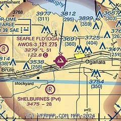
| Sectional chart |
|---|
|
| Airport distance calculator |
|---|
|
|
| Sunrise and sunset |
|---|
|
Times for 26-Apr-2025
| | Local
(UTC-6) | | Zulu
(UTC) |
|---|
| Morning civil twilight | | 05:23 | | 11:23 |
| Sunrise | | 05:52 | | 11:52 |
| Sunset | | 19:37 | | 01:37 |
| Evening civil twilight | | 20:07 | | 02:07 |
|
| Current date and time |
|---|
| Zulu (UTC) | 26-Apr-2025 06:37:15 |
|---|
| Local (UTC-6) | 26-Apr-2025 00:37:15 |
|---|
|
| METAR |
|---|
KOGA
5nm S | 260615Z AUTO 11008KT 10SM OVC009 07/06 A3023 RMK AO2 T00720058
|
KGGF
15nm S | 260615Z AUTO 13012KT 9SM OVC005 06/06 A3021 RMK AO2
|
|
| TAF |
|---|
KLBF
50nm E | 260530Z 2606/2706 11006KT P6SM VCSH OVC019 FM261000 13009KT P6SM OVC012 FM261500 13012KT P6SM VCSH OVC010 FM262000 15016G25KT P6SM OVC008 FM270400 14011G19KT P6SM OVC004
|
|
| NOTAMs |
|---|
NOTAMs are issued by the DoD/FAA and will open in a separate window not controlled by AirNav.
|
|


