FAA INFORMATION EFFECTIVE 20 FEBRUARY 2025
Location
| FAA Identifier: | CVG |
| Lat/Long: | 39-02-55.8150N 084-40-04.1550W
39-02.930250N 084-40.069250W
39.0488375,-84.6678208
(estimated) |
| Elevation: | 896.1 ft. / 273.1 m (surveyed) |
| Variation: | 06W (2025) |
| From city: | 8 miles SW of COVINGTON, KY |
| Time zone: | UTC -5 (UTC -4 during Daylight Saving Time) |
| Zip code: | 41018 |
Airport Operations
| Airport use: | Open to the public |
| Activation date: | 12/1944 |
| Control tower: | yes |
| ARTCC: | INDIANAPOLIS CENTER |
| FSS: | LOUISVILLE FLIGHT SERVICE STATION |
| NOTAMs facility: | CVG (NOTAM-D service available) |
| Attendance: | CONTINUOUS |
| Wind indicator: | lighted |
| Segmented circle: | no |
| Beacon: | white-green (lighted land airport)
Operates sunset to sunrise. |
| Fire and rescue: | ARFF index C |
| Airline operations: | ARFF INDEX D/E AVBL UPON REQ. |
| International operations: | customs landing rights airport |
Airport Communications
| UNICOM: | 122.95 |
| WX ASOS: | 134.375 (859-767-8210) |
| CINCINNATI GROUND: | 121.7 |
| CINCINNATI TOWER: | 118.3 ;RWY 09/27, 18C/36C 118.975 ;RWY 18L/36R 133.325 ;RWY 18R/36L 360.85 ;RWY 18L/36R |
| CINCINNATI APPROACH: | 119.7 ;090-269 123.875 ;270-089 363.15 |
| CINCINNATI DEPARTURE: | 126.65 ;001-180 128.7 ;181-360 254.25 |
| CLEARANCE DELIVERY: | 127.175 |
| CINCE STAR: | 254.25 |
| CLASS B: | 121.0 ;001-180 128.7 ;181-360 254.25 |
| D-ATIS: | 134.375 ;ARR 135.3 ;DEP |
| EMERG: | 121.5 243.0 |
| JAKIE STAR: | 119.7 254.25 |
| WX ASOS at LUK (12 nm E): | PHONE 513-321-6291 |
| WX AWOS-3PT at I67 (14 nm N): | 118.15 (513-569-4964) |
- ASSC IN USE. OPERATE TRANSPONDERS WITH ALTITUDE REPORTING MODE AND ADS-B (IF EQUIPPED) ENABLED ON ALL AIRPORT SURFACES.
Nearby radio navigation aids
| VOR radial/distance | | VOR name | | Freq | | Var |
|---|
| CVGr044/2.6 | | CINCINNATI VORTAC | | 117.30 | | 04W |
| FLMr329/29.2 | | FALMOUTH VOR/DME | | 117.00 | | 04W |
| NDB name | | Hdg/Dist | | Freq | | Var | | ID |
|---|
| SPORTYS | | 269/21.1 | | 245 | | 04W | | PWF | .--. .-- ..-. |
| BATESVILLE | | 128/32.8 | | 254 | | 05W | | HLB | .... .-.. -... |
Airport Services
| Fuel available: | 100LL JET-A |
| Parking: | hangars and tiedowns |
| Airframe service: | MAJOR |
| Powerplant service: | MAJOR |
Runway Information
Runway 9/27
| Dimensions: | 12001 x 150 ft. / 3658 x 46 m |
| Surface: | asphalt/concrete/grooved, in good condition |
| Weight bearing capacity: | | PCN 101/R/B/W/T | | Single wheel: | 120.0 | | Double wheel: | 250.0 | | Double tandem: | 550.0 | | Dual double tandem: | 875.0 |
|
| Runway edge lights: | high intensity |
| Operational restrictions: | W 4200 FT & E 750 FT CONC; REMAINDER ASPH OVERLAY. |
| RUNWAY 9 | | RUNWAY 27 |
| Latitude: | 39-02.781748N | | 39-02.775683N |
| Longitude: | 084-41.705890W | | 084-39.170732W |
| Elevation: | 883.3 ft. | | 875.0 ft. |
| Traffic pattern: | left | | left |
| Runway heading: | 096 magnetic, 090 true | | 276 magnetic, 270 true |
| Declared distances: | TORA:12000 TODA:12000 ASDA:11640 LDA:11640 | | TORA:12000 TODA:12000 ASDA:12000 LDA:12000 |
| Markings: | precision, in good condition | | precision, in good condition |
| Visual slope indicator: | 4-light PAPI on left (3.00 degrees glide path) | | 4-light PAPI on left (3.00 degrees glide path) |
| RVR equipment: | touchdown, rollout | | touchdown, rollout |
| Approach lights: | MALSR: 1,400 foot medium intensity approach lighting system with runway alignment indicator lights | | MALSR: 1,400 foot medium intensity approach lighting system with runway alignment indicator lights |
| Centerline lights: | yes | | yes |
| Touchdown point: | yes, lighted | | yes, no lights |
| Instrument approach: | ILS/DME | | ILS |
Runway 18C/36C
| Dimensions: | 11000 x 150 ft. / 3353 x 46 m |
| Surface: | asphalt/concrete/grooved, in good condition |
| Weight bearing capacity: | | PCN 112/F/C/W/T | | Single wheel: | 120.0 | | Double wheel: | 250.0 | | Double tandem: | 550.0 | | Dual double tandem: | 875.0 |
|
| Runway edge lights: | high intensity |
| RUNWAY 18C | | RUNWAY 36C |
| Latitude: | 39-03.884557N | | 39-02.072587N |
| Longitude: | 084-40.117055W | | 084-40.124515W |
| Elevation: | 874.6 ft. | | 840.7 ft. |
| Traffic pattern: | left | | left |
| Runway heading: | 186 magnetic, 180 true | | 006 magnetic, 000 true |
| Markings: | precision, in good condition | | precision, in good condition |
| Visual slope indicator: | 4-light PAPI on right (3.00 degrees glide path) | | 4-light PAPI on left (3.00 degrees glide path) |
| RVR equipment: | touchdown, midfield, rollout | | touchdown, midfield, rollout |
| Approach lights: | MALSR: 1,400 foot medium intensity approach lighting system with runway alignment indicator lights | | ALSF2: standard 2,400 foot high intensity approach lighting system with centerline sequenced flashers (category II or III) |
| Centerline lights: | yes | | yes |
| Touchdown point: | yes, lighted | | yes, lighted |
| Instrument approach: | ILS/DME | | ILS/DME |
Runway 18L/36R
| Dimensions: | 10000 x 150 ft. / 3048 x 46 m |
| Surface: | concrete/grooved, in good condition |
| Weight bearing capacity: | | PCN 127/R/B/W/T | | Single wheel: | 120.0 | | Double wheel: | 250.0 | | Double tandem: | 550.0 | | Dual double tandem: | 875.0 |
|
| Runway edge lights: | high intensity |
| RUNWAY 18L | | RUNWAY 36R |
| Latitude: | 39-03.351302N | | 39-01.704010N |
| Longitude: | 084-38.800080W | | 084-38.807603W |
| Elevation: | 886.3 ft. | | 896.1 ft. |
| Traffic pattern: | left | | left |
| Runway heading: | 186 magnetic, 180 true | | 006 magnetic, 000 true |
| Markings: | precision, in good condition | | precision, in good condition |
| Visual slope indicator: | 4-light PAPI on left (3.00 degrees glide path) | | 4-light PAPI on right (3.00 degrees glide path) |
| RVR equipment: | touchdown, midfield, rollout | | touchdown, midfield, rollout |
| Approach lights: | MALSR: 1,400 foot medium intensity approach lighting system with runway alignment indicator lights | | ALSF2: standard 2,400 foot high intensity approach lighting system with centerline sequenced flashers (category II or III) |
| Centerline lights: | yes | | yes |
| Touchdown point: | yes, lighted | | yes, lighted |
| Instrument approach: | ILS/DME | | ILS/DME |
Runway 18R/36L
| Dimensions: | 8000 x 150 ft. / 2438 x 46 m |
| Surface: | concrete/grooved, in good condition |
| Weight bearing capacity: | | PCN 170/R/B/W/T | | Single wheel: | 120.0 | | Double wheel: | 250.0 | | Double tandem: | 550.0 | | Dual double tandem: | 875.0 |
|
| Runway edge lights: | high intensity |
| Operational restrictions: | CLSD TO ACR WITH WINGSPAN GTR THAN 140 FT. |
| RUNWAY 18R | | RUNWAY 36L |
| Latitude: | 39-04.252893N | | 39-02.935062N |
| Longitude: | 084-41.024253W | | 084-41.029347W |
| Elevation: | 864.7 ft. | | 872.6 ft. |
| Traffic pattern: | left | | left |
| Runway heading: | 186 magnetic, 180 true | | 006 magnetic, 000 true |
| Markings: | precision, in good condition | | precision, in good condition |
| RVR equipment: | touchdown, midfield, rollout | | touchdown, midfield, rollout |
| Approach lights: | ALSF2: standard 2,400 foot high intensity approach lighting system with centerline sequenced flashers (category II or III) | | ALSF2: standard 2,400 foot high intensity approach lighting system with centerline sequenced flashers (category II or III) |
| Centerline lights: | yes | | yes |
| Touchdown point: | yes, lighted | | yes, lighted |
| Instrument approach: | ILS/DME | | ILS/DME |
Airport Ownership and Management from official FAA records
| Ownership: | Publicly-owned |
| Owner: | KENTON COUNTY ARPT BOARD
PO BOX 752000
CINCINNATI, OH 45275-2000
Phone 859-767-3151 |
| Manager: | CANDACE MCGRAW
PO BOX 752000
CINCINNATI, OH 45275-2000
Phone 859-767-3151 |
Additional Remarks
| - | SUCCESSIVE OR SIMUL DEP FM RWY 18L, 18C, 36L, 36C & 36R APVD WITH COURSE DVRG BGN NO FURTHER THAN 2 MI FM EOR DUE TO NOISE ABATEMENT. |
| - | TWYS RSTRD TO 15 MPH OR LESS WITH WINGSPAN 214 FT OR MORE. |
| - | BIRDS ON & INVOF THE ARPT. |
| - | RAMP CTL: RAMP 1N / 1S TXL & RAMP 2N / 2S TXL - 130.90, RAMP 3 TXL & N TXL - 130.375; DHL RAMP CTL: 129.475; AMZ RAMP CTL: 130.5. |
| - | NOISE SENS AREA N & S OF ARPT; RWY ASGN 2200-0700 BASED ON NOISE ABATEMENT. |
Instrument Procedures
NOTE: All procedures below are presented as PDF files. If you need a reader for these files, you should download the free Adobe Reader.NOT FOR NAVIGATION. Please procure official charts for flight.
FAA instrument procedures published for use from 20 February 2025 at 0901Z to 20 March 2025 at 0900Z.
STARs - Standard Terminal Arrivals |
|---|
| CEGRM SIX (RNAV) | |
2 pages:
[1] [2] (425KB) |
| GAVNN SEVEN (RNAV) | |
2 pages:
[1] [2] (402KB) |
| JAKIE SIX (RNAV) | |
2 pages:
[1] [2] (442KB) |
| SARGO FOUR (RNAV) | |
2 pages:
[1] [2] (389KB) |
| TIGRR FOUR (RNAV) | |
download (314KB) |
IAPs - Instrument Approach Procedures |
|---|
| ILS OR LOC RWY 09 | |
download (299KB) |
| ILS OR LOC RWY 18C | |
download (321KB) |
| ILS OR LOC RWY 18L | |
download (329KB) |
| ILS OR LOC RWY 18R | |
download (308KB) |
| ILS OR LOC RWY 27 | |
download (302KB) |
| ILS OR LOC RWY 36C | |
download (364KB) |
| ILS OR LOC RWY 36L | |
download (338KB) |
| ILS OR LOC RWY 36R | |
download (330KB) |
| ILS RWY 18C (SA CAT I - II) | |
download (334KB) |
| ILS RWY 27 (SA CAT I - II) | |
download (286KB) |
| ILS RWY 18R (CAT II) | |
download (284KB) |
| ILS RWY 36L (CAT II) | |
download (297KB) |
| ILS RWY 36C (CAT II - III) | |
download (327KB) |
| ILS RWY 36R (CAT II - III) | |
download (320KB) |
| RNAV (RNP) Z RWY 09 | |
download (248KB) |
| RNAV (RNP) Z RWY 18C | |
download (270KB) |
| RNAV (RNP) Z RWY 18L | |
download (271KB) |
| RNAV (RNP) Z RWY 18R | |
download (260KB) |
| RNAV (RNP) Z RWY 27 | |
download (269KB) |
| RNAV (RNP) Z RWY 36C | |
download (288KB) |
| RNAV (RNP) Z RWY 36L | |
download (261KB) |
| RNAV (RNP) Z RWY 36R | |
download (274KB) |
| RNAV (GPS) Y RWY 09 | |
download (265KB) |
| RNAV (GPS) Y RWY 18C | |
download (298KB) |
| RNAV (GPS) Y RWY 18L | |
download (299KB) |
| RNAV (GPS) Y RWY 18R | |
download (276KB) |
| RNAV (GPS) Y RWY 27 | |
download (274KB) |
| RNAV (GPS) Y RWY 36C | |
download (312KB) |
| RNAV (GPS) Y RWY 36L | |
download (294KB) |
| RNAV (GPS) Y RWY 36R | |
download (322KB) |
| NOTE: Special Alternate Minimums apply | |
download (138KB) |
Departure Procedures |
|---|
| BNGLE FIVE (RNAV) | |
2 pages:
[1] [2] (461KB) |
| CHCLL SIX (RNAV) | |
2 pages:
[1] [2] (449KB) |
| CINCINNATI SIX | |
2 pages:
[1] [2] (326KB) |
| GIPLE SEVEN (RNAV) | |
2 pages:
[1] [2] (566KB) |
| HAGOL FIVE (RNAV) | |
2 pages:
[1] [2] (478KB) |
| JBNCH SIX (RNAV) | |
2 pages:
[1] [2] (441KB) |
| KENLN SIX (RNAV) | |
2 pages:
[1] [2] (429KB) |
| LOVEY SEVEN (RNAV) | |
2 pages:
[1] [2] (485KB) |
| ROCKT THREE (RNAV) | |
2 pages:
[1] [2] (553KB) |
| SILKS SIX (RNAV) | |
2 pages:
[1] [2] (429KB) |
| NOTE: Special Take-Off Minimums/Departure Procedures apply | |
download (126KB) |
Other nearby airports with instrument procedures:
KLUK - Cincinnati Municipal Airport/Lunken Field (12 nm E)
I67 - Cincinnati West Airport (14 nm N)
KHAO - Butler County Regional Airport/Hogan Field (20 nm N)
I69 - Clermont County Airport (21 nm E)
K62 - Gene Snyder Airport (24 nm SE)
|
|

Road maps at:
MapQuest
Bing
Google
| Aerial photo |
|---|
WARNING: Photo may not be current or correct
 Photo taken 25-May-2018
looking south.
Photo taken 25-May-2018
looking south.
Do you have a better or more recent aerial photo of Cincinnati/Northern Kentucky International Airport that you would like to share? If so, please send us your photo.
|
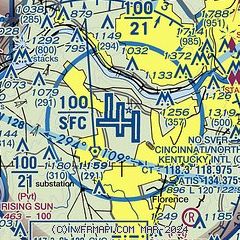
| Sectional chart |
|---|
|
CAUTION: Diagram may not be current
 Download PDF
of official airport diagram from the FAA
| Airport distance calculator |
|---|
|
|
| Sunrise and sunset |
|---|
|
Times for 11-Mar-2025
| | Local
(UTC-5) | | Zulu
(UTC) |
|---|
| Morning civil twilight | | 06:31 | | 11:31 |
| Sunrise | | 06:57 | | 11:57 |
| Sunset | | 18:40 | | 23:40 |
| Evening civil twilight | | 19:07 | | 00:07 |
|
| Current date and time |
|---|
| Zulu (UTC) | 11-Mar-2025 16:41:16 |
|---|
| Local (UTC-5) | 11-Mar-2025 11:41:16 |
|---|
|
| METAR |
|---|
| KCVG | 111552Z 23008KT 10SM CLR 18/01 A2979 RMK AO2 SLP082 T01830006
|
KLUK
12nm E | 111553Z 24009KT 9SM CLR 19/01 A2979 RMK AO2 SLP086 T01940006
|
KI67
14nm N | 111615Z AUTO 24011G16KT 10SM CLR 20/02 A2976 RMK AO1
|
|
| TAF |
|---|
| KCVG | 111502Z 1115/1218 22013KT P6SM SKC FM111600 24014G22KT P6SM FEW250 FM112300 27006KT P6SM SCT050 FM120500 05008KT P6SM BKN050
|
KLUK
12nm E | 111502Z 1115/1212 22011KT P6SM SKC FM111600 24014G21KT P6SM FEW250 FM112300 27006KT P6SM SCT050 FM120500 05004KT P6SM BKN050
|
|
| NOTAMs |
|---|
NOTAMs are issued by the DoD/FAA and will open in a separate window not controlled by AirNav.
|
|


