FAA INFORMATION EFFECTIVE 17 APRIL 2025
Location
| FAA Identifier: | CZL |
| Lat/Long: | 34-27-19.4490N 084-56-20.9590W
34-27.324150N 084-56.349317W
34.4554025,-84.9391553
(estimated) |
| Elevation: | 655.8 ft. / 199.9 m (surveyed) |
| Variation: | 05W (2015) |
| From city: | 3 miles S of CALHOUN, GA |
| Time zone: | UTC -4 (UTC -5 during Standard Time) |
| Zip code: | 30701 |
Airport Operations
| Airport use: | Open to the public |
| Activation date: | 04/1964 |
| Control tower: | no |
| ARTCC: | ATLANTA CENTER |
| FSS: | MACON FLIGHT SERVICE STATION |
| NOTAMs facility: | MCN (NOTAM-D service available) |
| Attendance: | NOV-MAR 0800-1800, APR-OCT 0800-2000 |
| Wind indicator: | lighted |
| Segmented circle: | no |
| Lights: | ACTVT PAPI RWY 17 & 35; MIRL RWY 17/35 - CTAF. MIRL RWY 17/35 PRESET ON MED INTST DUSK - 2200, TO INCR INTST & ACTVT AFT 2200 - CTAF. |
| Beacon: | white-green (lighted land airport)
Operates sunset to sunrise. |
Airport Communications
| CTAF/UNICOM: | 122.8 |
| WX AWOS-3PT: | 119.975 (706-578-1205) |
| WX ASOS at RMG (13 nm SW): | 119.925 (706-204-9617) |
| WX AWOS-3PT at DNN (16 nm N): | 127.65 (706-278-7010) |
- APCH/DEP SVC PRVDD BY ATLANTA ARTCC ON FREQS 124.5/270.325 (GADSDEN RCAG).
Nearby radio navigation aids
| VOR radial/distance | | VOR name | | Freq | | Var |
|---|
| RMGr026/19.7 | | ROME VORTAC | | 115.40 | | 01E |
Airport Services
| Fuel available: | 100LL JET-A+ |
| Parking: | hangars and tiedowns |
| Airframe service: | MAJOR |
| Powerplant service: | MAJOR |
| Bottled oxygen: | NONE |
| Bulk oxygen: | NONE |
Runway Information
Runway 17/35
| Dimensions: | 6034 x 100 ft. / 1839 x 30 m |
| Surface: | asphalt, in good condition |
| Weight bearing capacity: | | Single wheel: | 15.0 | | Double wheel: | 100.0 | | Double tandem: | 100.0 |
|
| Runway edge lights: | medium intensity |
| RUNWAY 17 | | RUNWAY 35 |
| Latitude: | 34-27.810917N | | 34-26.837370N |
| Longitude: | 084-56.472455W | | 084-56.226193W |
| Elevation: | 638.6 ft. | | 655.8 ft. |
| Traffic pattern: | left | | left |
| Runway heading: | 173 magnetic, 168 true | | 353 magnetic, 348 true |
| Displaced threshold: | no | | 386 ft. |
| Declared distances: | TORA:6034 TODA:6034 ASDA:6034 LDA:6034 | | TORA:6034 TODA:6034 ASDA:6034 LDA:5648 |
| Markings: | nonprecision, in good condition | | nonprecision, in good condition |
| Visual slope indicator: | 4-light PAPI on left (3.50 degrees glide path) | | 4-light PAPI on left (3.00 degrees glide path) |
| Touchdown point: | yes, no lights | | yes, no lights |
| Instrument approach: | | | LOCALIZER |
| Obstructions: | 21 ft. trees, 347 ft. from runway, 220 ft. right of centerline, 7:1 slope to clear | | 97 ft. trees, 1752 ft. from runway, 420 ft. left of centerline, 16:1 slope to clear
APCH SLOPE 20:1 TO DSPLCD THLD, TREES 2172 FT OUT, 318 LEFT. |
Airport Ownership and Management from official FAA records
| Ownership: | Publicly-owned |
| Owner: | CALHOUN-GORDON CO ARPT AUTH
1957 HWY 41 S
CALHOUN, GA 30701
Phone 706-602-8000 |
| Manager: | DWIGHT ALBRITTON
1957 HWY 41 S
CALHOUN, GA 30701
Phone 706-602-8000 |
Additional Remarks
| - | SELF-SVC FUEL AVBL WITH CREDIT CARD. |
| - | DEER & WILDLIFE ON OR INVOF ARPT. |
| - | FOR CD CTC ATLANTA ARTCC AT 770-210-7692. |
Instrument Procedures
NOTE: All procedures below are presented as PDF files. If you need a reader for these files, you should download the free Adobe Reader.NOT FOR NAVIGATION. Please procure official charts for flight.
FAA instrument procedures published for use from 17 April 2025 at 0901Z to 15 May 2025 at 0900z.
IAPs - Instrument Approach Procedures |
|---|
| RNAV (GPS) RWY 17 | |
download (226KB) |
| RNAV (GPS) RWY 35 | |
download (206KB) |
| NOTE: Special Alternate Minimums apply | |
download (158KB) |
| NOTE: Special Take-Off Minimums/Departure Procedures apply | |
download (489KB) |
Other nearby airports with instrument procedures:
KRMG - Richard B. Russell Regional Airport - J.H. Towers Field (13 nm SW)
KDNN - Dalton Municipal Airport (16 nm N)
KVPC - Cartersville Airport (20 nm S)
9A5 - Barwick Lafayette Airport (22 nm NW)
49A - Gilmer County Airport (23 nm NE)
|
|

Road maps at:
MapQuest
Bing
Google
| Aerial photo |
|---|
WARNING: Photo may not be current or correct
 Photo by Mary Gadd
Photo taken 02-Aug-2013
looking northeast.
Photo by Mary Gadd
Photo taken 02-Aug-2013
looking northeast.
Do you have a better or more recent aerial photo of Tom B David Field Airport that you would like to share? If so, please send us your photo.
|
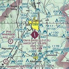
| Sectional chart |
|---|
|
| Airport distance calculator |
|---|
|
|
| Sunrise and sunset |
|---|
|
Times for 30-Apr-2025
| | Local
(UTC-4) | | Zulu
(UTC) |
|---|
| Morning civil twilight | | 06:25 | | 10:25 |
| Sunrise | | 06:52 | | 10:52 |
| Sunset | | 20:22 | | 00:22 |
| Evening civil twilight | | 20:49 | | 00:49 |
|
| Current date and time |
|---|
| Zulu (UTC) | 01-May-2025 00:02:18 |
|---|
| Local (UTC-4) | 30-Apr-2025 20:02:18 |
|---|
|
| METAR |
|---|
| KCZL | 302355Z AUTO 00000KT 10SM CLR 26/20 A2999 RMK AO2 10304 20267
|
KRMG
13nm SW | 302353Z AUTO 00000KT 10SM CLR 25/19 A2999 RMK AO2 SLP147 T02500189 10300 20250 56010
|
KDNN
18nm NW | 302355Z AUTO VRB03KT 10SM FEW100 27/17 A2999 RMK AO2 T02690171
|
KVPC
20nm S | 302355Z AUTO 00000KT CLR 27/17 A3002 RMK AO2 PWINO
|
|
| TAF |
|---|
KRYY
31nm SE | 301735Z 3018/0118 23006KT P6SM FEW040 BKN060 FM302000 21005KT P6SM SCT060 SCT100 FM010300 18004KT P6SM BKN250 FM011600 20008KT P6SM BKN040
|
KCHA
37nm N | 301721Z 3018/0118 19007KT P6SM VCTS SCT035CB BKN250 FM302200 VRB03KT P6SM FEW060 BKN250 FM011500 19009KT P6SM SCT050 BKN250
|
KMGE
39nm SE | 302100Z 3021/0203 20009KT 9999 BKN055 BKN250 QNH3004INS BECMG 3023/3024 VRB05KT 9999 FEW055 SCT250 QNH3005INS BECMG 0114/0115 21010G15KT 9999 BKN040 BKN250 QNH2999INS BECMG 0123/0124 19006KT 9999 FEW050 SCT250 QNH3000INS TX29/3021Z TN20/0112Z LAST NO AMDS AFT 0103 NEXT 0111
|
|
| NOTAMs |
|---|
NOTAMs are issued by the DoD/FAA and will open in a separate window not controlled by AirNav.
|
|


