FAA INFORMATION EFFECTIVE 20 FEBRUARY 2025
Location
| FAA Identifier: | DTN |
| Lat/Long: | 32-32-26.9580N 093-44-37.8070W
32-32.449300N 093-44.630117W
32.5408217,-93.7438353
(estimated) |
| Elevation: | 179.3 ft. / 54.7 m (surveyed) |
| Variation: | 01E (2020) |
| From city: | 3 miles N of SHREVEPORT, LA |
| Time zone: | UTC -6 (UTC -5 during Daylight Saving Time) |
| Zip code: | 71111 |
Airport Operations
| Airport use: | Open to the public |
| Activation date: | 04/1940 |
| Control tower: | yes |
| ARTCC: | FORT WORTH CENTER |
| FSS: | DE RIDDER FLIGHT SERVICE STATION |
| NOTAMs facility: | DTN (NOTAM-D service available) |
| Attendance: | 0700-2200 |
| Wind indicator: | lighted |
| Segmented circle: | no |
| Lights: | SS-SR |
| Beacon: | white-green (lighted land airport)
Operates sunset to sunrise. |
Airport Communications
| CTAF: | 120.225 |
| UNICOM: | 122.95 |
| WX ASOS: | 118.525 (318-425-7967) |
| DOWNTOWN GROUND: | 121.65 [0700-2200] |
| DOWNTOWN TOWER: | 120.225 284.6 [0700-2200] |
| SHREVEPORT APPROACH: | 119.9 ;153-319 123.75 ;320-152 |
| SHREVEPORT DEPARTURE: | 119.9 ;153-319 123.75 ;320-152 |
| CLEARANCE DELIVERY: | 119.9 ;WHEN TWR CLSD 121.65 |
| WX ASOS at SHV (7 nm SW): | 128.45 (318-216-0546) |
- CLNC DEL ON GND CON 121.65 (WHEN ATCT CLSD CLNC DEL PRVDD BY SHV DEP CON ON FREQ 119.9).
Nearby radio navigation aids
| VOR radial/distance | | VOR name | | Freq | | Var |
|---|
| EMGr311/11.3 | | ELM GROVE VORTAC | | 111.20 | | 07E |
| EICr159/14.2 | | BELCHER VORTAC | | 117.40 | | 07E |
Airport Services
| Fuel available: | 100LL JET-A
A:FOR JET A AFT HRS CALL 318-510-4330. AVBL 24 HR SELF SERVICE WITH CREDIT CARD
100LL:100LL AVBL 24 HR SELF SERVICE WITH CREDIT CARD. |
| Parking: | hangars and tiedowns |
| Airframe service: | MAJOR |
| Powerplant service: | MAJOR |
| Bottled oxygen: | HIGH |
| Bulk oxygen: | LOW |
Runway Information
Runway 14/32
| Dimensions: | 5016 x 150 ft. / 1529 x 46 m |
| Surface: | asphalt, in good condition |
| Weight bearing capacity: | | Single wheel: | 35.0 | | Double wheel: | 55.0 |
|
| Runway edge lights: | high intensity |
| RUNWAY 14 | | RUNWAY 32 |
| Latitude: | 32-32.757632N | | 32-32.120875N |
| Longitude: | 093-45.025775W | | 093-44.402287W |
| Elevation: | 177.9 ft. | | 179.1 ft. |
| Traffic pattern: | left | | left |
| Runway heading: | 139 magnetic, 140 true | | 319 magnetic, 320 true |
| Markings: | nonprecision, in good condition | | nonprecision, in good condition |
| Visual slope indicator: | 4-light PAPI on left (3.00 degrees glide path)
PAPI UNUSBL BYD 8 DEGS RIGHT OF CNTRLN | | 4-light PAPI on right (3.00 degrees glide path) |
| Runway end identifier lights: | yes | | yes |
| Touchdown point: | yes, no lights | | yes, no lights |
| Instrument approach: | LOC/DME | | |
| Obstructions: | 63 ft. trees, 1844 ft. from runway, 32 ft. right of centerline, 25:1 slope to clear | | 79 ft. trees, 2226 ft. from runway, 25:1 slope to clear |
Runway 5/23
| Dimensions: | 4198 x 75 ft. / 1280 x 23 m |
| Surface: | asphalt, in fair condition |
| Weight bearing capacity: | |
| Runway edge lights: | medium intensity |
| RUNWAY 5 | | RUNWAY 23 |
| Latitude: | 32-32.264362N | | 32-32.658193N |
| Longitude: | 093-44.865917W | | 093-44.193785W |
| Elevation: | 173.1 ft. | | 175.0 ft. |
| Traffic pattern: | left | | left |
| Runway heading: | 054 magnetic, 055 true | | 234 magnetic, 235 true |
| Markings: | nonprecision, in fair condition | | nonprecision, in fair condition |
| Visual slope indicator: | 2-light PAPI on left (3.00 degrees glide path) | | 2-light PAPI on left (3.00 degrees glide path) |
| Runway end identifier lights: | yes
REIL OTS INDEFLY. | | yes
REIL OTS INDEFLY. |
| Touchdown point: | yes, no lights | | yes, no lights |
| Obstructions: | 6 ft. fence, 200 ft. from runway
+6 FT FENCE 120 FT FM RY END ACRS APCH; +15 FT ROAD 188 FT FROM RY END. | | 40 ft. trees, 1800 ft. from runway, 40:1 slope to clear |
Airport Ownership and Management from official FAA records
| Ownership: | Publicly-owned |
| Owner: | SHREVEPORT ARPT AUTHORITY
5103 HOLLYWOOD, SUITE 300
SHREVEPORT, LA 71109-7764
Phone 318-673-5370 |
| Manager: | BRUCE HOLLANDER
1550 AIRPORT ROAD, SUITE 100
SHREVEPORT, LA 71107
Phone 318-349-8330 |
Additional Remarks
| - | ALL VFR TFC REMAIN WITHIN 1 1/2 MILES NE THRU SW FM THE CENTER OF THE ARPT DUE TO SHREVEPORT/BARKSDALE AFB CLASS C AIRSPACE. |
| - | RWY 14 DESIGNATED CALM WIND RWY. |
| - | ACFT/VEHICLES NOT VSBL FROM ATCT ON N 685 FT OF TWY F. |
| - | WILDLIFE - DEER & BIRDS ON & INVOF ARPT. |
Instrument Procedures
NOTE: All procedures below are presented as PDF files. If you need a reader for these files, you should download the free Adobe Reader.NOT FOR NAVIGATION. Please procure official charts for flight.
FAA instrument procedures published for use from 20 February 2025 at 0901Z to 20 March 2025 at 0900Z.
IAPs - Instrument Approach Procedures |
|---|
| RNAV (GPS) RWY 05 **CHANGED** | |
download (231KB) |
| RNAV (GPS) RWY 14 **CHANGED** | |
download (281KB) |
| RNAV (GPS) RWY 23 **CHANGED** | |
download (229KB) |
| RNAV (GPS) RWY 32 **CHANGED** | |
download (264KB) |
| LOC RWY 14 **CHANGED** | |
download (292KB) |
| NOTE: Special Alternate Minimums apply | |
download (140KB) |
| NOTE: Special Take-Off Minimums/Departure Procedures apply | |
download (294KB) |
Other nearby airports with instrument procedures:
KBAD - Barksdale Air Force Base (5 nm SE)
KSHV - Shreveport Regional Airport (7 nm SW)
KMNE - Minden Airport (23 nm E)
3F4 - Vivian Airport (23 nm NW)
3F3 - C E 'Rusty' Williams Airport (28 nm S)
|
|

Road maps at:
MapQuest
Bing
Google
| Aerial photo |
|---|
WARNING: Photo may not be current or correct
 Photo by Zac Proano
Photo taken 13-Jul-2018
looking southeast.
Photo by Zac Proano
Photo taken 13-Jul-2018
looking southeast.
Do you have a better or more recent aerial photo of Shreveport Downtown Airport that you would like to share? If so, please send us your photo.
|
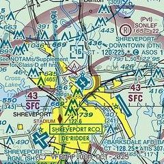
| Sectional chart |
|---|
|
CAUTION: Diagram may not be current
 Download PDF
of official airport diagram from the FAA
| Airport distance calculator |
|---|
|
|
| Sunrise and sunset |
|---|
|
Times for 12-Mar-2025
| | Local
(UTC-6) | | Zulu
(UTC) |
|---|
| Morning civil twilight | | 06:06 | | 12:06 |
| Sunrise | | 06:30 | | 12:30 |
| Sunset | | 18:20 | | 00:20 |
| Evening civil twilight | | 18:44 | | 00:44 |
|
| Current date and time |
|---|
| Zulu (UTC) | 12-Mar-2025 16:52:44 |
|---|
| Local (UTC-6) | 12-Mar-2025 10:52:44 |
|---|
|
| METAR |
|---|
| KDTN | 121553Z 21015KT 10SM -RA FEW020 20/14 A2988 RMK AO2 SLP115 P0000 T02000139
|
KBAD
5nm SE | 121630Z AUTO 17014KT 10SM SCT023 21/15 A2987 RMK AO2 SLP118
|
KSHV
7nm SW | 121556Z 21015G19KT 10SM SCT018 20/14 A2987 RMK SLPNO
|
|
| TAF |
|---|
KBAD
5nm SE | 121430Z 1214/1318 19014G22KT 9999 BKN015 QNH2985INS BECMG 1215/1217 19015G25KT 9999 BKN020 QNH2975INS BECMG 1300/1301 17012G18KT 9999 VCTS BKN045CB OVC120 WS019/23038KT QNH2973INS BECMG 1311/1312 15010KT 9999 NSW OVC015 QNH2976INS BECMG 1315/1316 16010G15KT 9999 BKN020 QNH2981INS TX26/1221Z TN13/1312Z
|
KSHV
7nm SW | 121120Z 1212/1312 21011G18KT P6SM BKN013 TEMPO 1212/1216 BKN020 FM121600 21012G22KT P6SM FEW020 FM121900 19012G22KT P6SM BKN140 FM130000 17010KT P6SM BKN250 FM130800 19008KT 6SM BR OVC015
|
|
| NOTAMs |
|---|
NOTAMs are issued by the DoD/FAA and will open in a separate window not controlled by AirNav.
|
|


