FAA INFORMATION EFFECTIVE 20 FEBRUARY 2025
Location
| FAA Identifier: | DWX |
| Lat/Long: | 41-02-14.7890N 107-29-33.1010W
41-02.246483N 107-29.551683W
41.0374414,-107.4925281
(estimated) |
| Elevation: | 6548.9 ft. / 1996.1 m (surveyed) |
| Variation: | 09E (2020) |
| From city: | 2 miles E of DIXON, WY |
| Time zone: | UTC -7 (UTC -6 during Daylight Saving Time) |
| Zip code: | 82332 |
Airport Operations
| Airport use: | Open to the public |
| Activation date: | 07/1979 |
| Control tower: | no |
| ARTCC: | DENVER CENTER |
| FSS: | CASPER FLIGHT SERVICE STATION |
| NOTAMs facility: | DWX (NOTAM-D service available) |
| Attendance: | UNATNDD |
| Wind indicator: | lighted |
| Segmented circle: | yes |
| Lights: | ACTV REILS RWY 6 & 24; PAPI RWY 6, MIRL RWY 06/24 - CTAF. |
| Beacon: | white-green (lighted land airport)
Operates sunset to sunrise. |
Airport Communications
| CTAF: | 122.9 |
| WX AWOS-3PT: | 119.425 (307-383-2504) |
- APCH/DEP CTL SVC PRVDD BY DENVER ARTCC (ZDV) ON FREQS 120.475/235.975 (HAYDEN RCAG).
Nearby radio navigation aids
| VOR radial/distance | | VOR name | | Freq | | Var |
|---|
| CHEr331/32.2 | | HAYDEN VOR/DME | | 115.60 | | 14E |
Airport Services
| Fuel available: | 100LL
100LL:FUEL 24 HR CREDIT CARD SVC AVBL. |
| Parking: | tiedowns |
| Airframe service: | NONE |
| Powerplant service: | NONE |
| Bottled oxygen: | NONE |
| Bulk oxygen: | NONE |
Runway Information
Runway 6/24
| Dimensions: | 7000 x 75 ft. / 2134 x 23 m |
| Surface: | asphalt, in good condition |
| Weight bearing capacity: | |
| Runway edge lights: | medium intensity |
| RUNWAY 6 | | RUNWAY 24 |
| Latitude: | 41-02.058445N | | 41-02.434448N |
| Longitude: | 107-30.271078W | | 107-28.832215W |
| Elevation: | 6472.5 ft. | | 6548.9 ft. |
| Traffic pattern: | left | | left |
| Runway heading: | 062 magnetic, 071 true | | 242 magnetic, 251 true |
| Markings: | nonprecision, in fair condition | | nonprecision, in fair condition |
| Visual slope indicator: | 2-light PAPI on left (3.00 degrees glide path) | | |
| Runway end identifier lights: | yes | | yes |
| Touchdown point: | yes, no lights | | yes, no lights |
| Obstructions: | none | | 8 ft. brush, 324 ft. from runway, 14 ft. left of centerline, 15:1 slope to clear |
Airport Ownership and Management from official FAA records
| Ownership: | Publicly-owned |
| Owner: | CARBON COUNTY
PO BOX 6
RAWLINS, WY 82301
Phone 307-328-2668 |
| Manager: | KODY STOCKS
PO BOX 6
RAWLINS, WY 82301
Phone 307-380-7278 |
Additional Remarks
| - | WILDLIFE ON & INVOF ARPT. 6 FT WILDLIFE FENCE ALL AROUND ARPT WITH GATED, CATTLE GUARD ENTRANCES. |
| - | SNOW BANKS +4 FT ALONG ENTIRE RY WINTER MONTHS. |
| - | +500 FT TERRAIN 9700 FT FM AER 24. |
| - | FOR CD CTC DENVER ARTCC AT 303-651-4257. |
| - | COLD TEMPERATURE AIRPORT. ALTITUDE CORRECTION REQUIRED AT OR BELOW -37C. |
Instrument Procedures
NOTE: All procedures below are presented as PDF files. If you need a reader for these files, you should download the free Adobe Reader.NOT FOR NAVIGATION. Please procure official charts for flight.
FAA instrument procedures published for use from 20 February 2025 at 0901Z to 20 March 2025 at 0900Z.
IAPs - Instrument Approach Procedures |
|---|
| RNAV (GPS) RWY 24 | |
download (203KB) |
| NOTE: Special Alternate Minimums apply | |
download (622KB) |
|
|---|
| CARBON TWO (OBSTACLE) (RNAV) | |
2 pages:
[1] [2] (943KB) |
| CARBON TWO (OBSTACLE) (RNAV), CONT.2 | |
download (501KB) |
| DIXON TWO (OBSTACLE) (RNAV) | |
download (209KB) |
| NOTE: Special Take-Off Minimums/Departure Procedures apply | |
download (1012KB) |
Other nearby airports with instrument procedures:
KCAG - Craig-Moffat Airport (33 nm S)
KHDN - Yampa Valley Airport (36 nm S)
KSAA - Shively Field Airport (39 nm NE)
KSBS - Steamboat Springs Airport/Bob Adams Field (42 nm SE)
KRWL - Rawlins Municipal Airport/Harvey Field (48 nm N)
|
|

Road maps at:
MapQuest
Bing
Google
| Aerial photo |
|---|
WARNING: Photo may not be current or correct
 Photo courtesy of GDA Engineers
Photo taken 14-Jun-2011
looking northeast.
Photo courtesy of GDA Engineers
Photo taken 14-Jun-2011
looking northeast.
Do you have a better or more recent aerial photo of Dixon Airport that you would like to share? If so, please send us your photo.
|
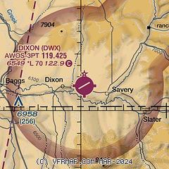
| Sectional chart |
|---|
|
| Airport distance calculator |
|---|
|
|
| Sunrise and sunset |
|---|
|
Times for 04-Mar-2025
| | Local
(UTC-7) | | Zulu
(UTC) |
|---|
| Morning civil twilight | | 06:13 | | 13:13 |
| Sunrise | | 06:40 | | 13:40 |
| Sunset | | 18:03 | | 01:03 |
| Evening civil twilight | | 18:31 | | 01:31 |
|
| Current date and time |
|---|
| Zulu (UTC) | 04-Mar-2025 18:57:30 |
|---|
| Local (UTC-7) | 04-Mar-2025 11:57:30 |
|---|
|
| METAR |
|---|
| KDWX | 041835Z AUTO 30011G15KT SCT021 BKN044 OVC065 02/M03 A3000 RMK AO2 T00151033 PWINO
|
|
| TAF |
|---|
KHDN
36nm S | 041739Z 0418/0518 27012KT P6SM VCSH SCT025 BKN035 TEMPO 0418/0420 4SM -SHSN BKN010 FM042000 29015G22KT P6SM VCSH SCT025 OVC050 FM050100 27009KT P6SM SCT035 BKN080 FM051200 10004KT P6SM BKN050
|
|
| NOTAMs |
|---|
NOTAMs are issued by the DoD/FAA and will open in a separate window not controlled by AirNav.
|
|


