FAA INFORMATION EFFECTIVE 20 FEBRUARY 2025
Location
| FAA Identifier: | RWL |
| Lat/Long: | 41-48-20.6000N 107-12-01.2000W
41-48.343333N 107-12.020000W
41.8057222,-107.2003333
(estimated) |
| Elevation: | 6816.7 ft. / 2077.7 m (surveyed) |
| Variation: | 10E (2015) |
| From city: | 2 miles NE of RAWLINS, WY |
| Time zone: | UTC -7 (UTC -6 during Daylight Saving Time) |
| Zip code: | 82301 |
Airport Operations
| Airport use: | Open to the public |
| Activation date: | 11/1937 |
| Control tower: | no |
| ARTCC: | DENVER CENTER |
| FSS: | CASPER FLIGHT SERVICE STATION |
| NOTAMs facility: | RWL (NOTAM-D service available) |
| Attendance: | MON-FRI 0700-1900, ALL SAT-SUN 0700-1700 |
| Wind indicator: | lighted |
| Segmented circle: | yes |
| Lights: | ACTVT REIL RWY 22 & 29; MIRL RWY 04/22 & 11/29 - CTAF. PAPI RWY 04 & 22 OPR CONSLY. |
| Beacon: | white-green (lighted land airport)
Operates sunset to sunrise. |
Airport Communications
| CTAF/UNICOM: | 123.0 |
| WX ASOS: | 118.525 (307-328-0031) |
- APCH/DEP CTL SVC PRVDD BY DENVER ARTCC (ZDV) ON FREQS 132.1/254.35 (CHEROKEE RCAG).
Nearby radio navigation aids
| VOR radial/distance | | VOR name | | Freq | | Var |
|---|
| CKWr065/17.3 | | CHEROKEE VOR/DME | | 115.00 | | 15E |
Airport Services
| Fuel available: | 100LL JET-A
100LL:PHONE NR FOR FUEL AFT HRS POSTED ON FBO DOOR. |
| Parking: | tiedowns |
| Airframe service: | NONE |
| Powerplant service: | NONE |
| Bottled oxygen: | NONE |
| Bulk oxygen: | NONE |
Runway Information
Runway 4/22
| Dimensions: | 7008 x 100 ft. / 2136 x 30 m |
| Surface: | asphalt/grooved, in good condition |
| Weight bearing capacity: | | Single wheel: | 30.0 | | Double wheel: | 60.0 |
|
| Runway edge lights: | medium intensity |
| RUNWAY 4 | | RUNWAY 22 |
| Latitude: | 41-48.004653N | | 41-48.681793N |
| Longitude: | 107-12.611152W | | 107-11.363010W |
| Elevation: | 6744.4 ft. | | 6816.6 ft. |
| Traffic pattern: | right | | left |
| Runway heading: | 044 magnetic, 054 true | | 224 magnetic, 234 true |
| Markings: | nonprecision, in fair condition | | nonprecision, in fair condition |
| Visual slope indicator: | 4-light PAPI on left (3.00 degrees glide path) | | 4-light PAPI on left (3.00 degrees glide path) |
| Runway end identifier lights: | | | yes |
| Touchdown point: | yes, no lights | | yes, no lights |
| Obstructions: | 29 ft. tank, 756 ft. from runway, 195 ft. left of centerline, 19:1 slope to clear | | none |
Runway 11/29
| Dimensions: | 4322 x 60 ft. / 1317 x 18 m |
| Surface: | asphalt, in good condition |
| Weight bearing capacity: | |
| Runway edge lights: | medium intensity |
| RUNWAY 11 | | RUNWAY 29 |
| Latitude: | 41-48.491983N | | 41-48.191093N |
| Longitude: | 107-12.503290W | | 107-11.641675W |
| Elevation: | 6776.4 ft. | | 6747.2 ft. |
| Traffic pattern: | left | | right |
| Runway heading: | 105 magnetic, 115 true | | 285 magnetic, 295 true |
| Markings: | basic, in fair condition | | basic, in fair condition |
| Runway end identifier lights: | | | yes |
| Touchdown point: | yes, no lights | | yes, no lights |
Airport Ownership and Management from official FAA records
| Ownership: | Publicly-owned |
| Owner: | RAWLINS CARBON CO ARPT BOARD
P.O. BOX 1363
RAWLINS, WY 82301
Phone 307-324-2361 |
| Manager: | BOB HEPNER
1300 AIRPORT ROAD
RAWLINS, WY 82301
Phone 307-321-5566 |
Additional Remarks
| - | 7800 FT MTN 3 MILES WEST, 7200 FT MTN 3 MILES SW, 7200 FT MTN 3 MILES NE. |
| - | RWY 11/29 LMTD TO ACFT UP TO 12000 LBS GWT. |
| - | REQ ALL ACFT DEPNG RWY 29 MAKE RIGHT TURNOUT AS SOON AS SAFETY PMTS AFT TKOF TO AVOID HOUSING AREA AND FOR NOISE ABATEMENT. |
| - | BIRDS INVOF ARPT RWYS. |
| - | FOR CD IF UNA TO CTC ON FSS FREQ, CTC DENVER ARTCC AT 303-651-4257. |
Instrument Procedures
NOTE: All procedures below are presented as PDF files. If you need a reader for these files, you should download the free Adobe Reader.NOT FOR NAVIGATION. Please procure official charts for flight.
FAA instrument procedures published for use from 20 February 2025 at 0901Z to 20 March 2025 at 0900Z.
IAPs - Instrument Approach Procedures |
|---|
| RNAV (GPS) RWY 22 | |
download (289KB) |
| NOTE: Special Alternate Minimums apply | |
download (185KB) |
| NOTE: Special Take-Off Minimums/Departure Procedures apply | |
download (525KB) |
Other nearby airports with instrument procedures:
KSAA - Shively Field Airport (27 nm SE)
KDWX - Dixon Airport (48 nm S)
KCPR - Casper/Natrona County International Airport (74 nm NE)
KLAR - Laramie Regional Airport (75 nm SE)
33V - Walden-Jackson County Airport (76 nm SE)
|
|

Road maps at:
MapQuest
Bing
Google
| Aerial photo |
|---|
WARNING: Photo may not be current or correct
 Photo by Blaine E. Fisher
Photo taken 17-Sep-2005
Photo by Blaine E. Fisher
Photo taken 17-Sep-2005
Do you have a better or more recent aerial photo of Rawlins Municipal Airport/Harvey Field that you would like to share? If so, please send us your photo.
|
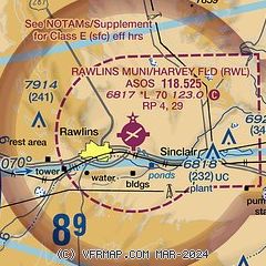
| Sectional chart |
|---|
|
CAUTION: Diagram may not be current

| Airport distance calculator |
|---|
|
|
| Sunrise and sunset |
|---|
|
Times for 04-Mar-2025
| | Local
(UTC-7) | | Zulu
(UTC) |
|---|
| Morning civil twilight | | 06:12 | | 13:12 |
| Sunrise | | 06:40 | | 13:40 |
| Sunset | | 18:01 | | 01:01 |
| Evening civil twilight | | 18:29 | | 01:29 |
|
| Current date and time |
|---|
| Zulu (UTC) | 04-Mar-2025 22:04:35 |
|---|
| Local (UTC-7) | 04-Mar-2025 15:04:35 |
|---|
|
| METAR |
|---|
| KRWL | 042153Z AUTO 31009KT 9SM -SN FEW024 OVC047 M01/M07 A3001 RMK AO2 SNE01B41 SLP170 P0000 T10061067
|
|
| TAF |
|---|
| KRWL | 041730Z 0418/0518 32014G22KT 6SM -SN BKN025 FM042000 30014G22KT P6SM BKN050 FM050000 29012KT P6SM BKN100 FM050600 26015G25KT P6SM BKN200
|
|
| NOTAMs |
|---|
NOTAMs are issued by the DoD/FAA and will open in a separate window not controlled by AirNav.
|
|


