FAA INFORMATION EFFECTIVE 17 APRIL 2025
Location
| FAA Identifier: | FYE |
| Lat/Long: | 35-12-27.7000N 089-23-40.0000W
35-12.461667N 089-23.666667W
35.2076944,-89.3944444
(estimated) |
| Elevation: | 435.8 ft. / 133 m (estimated) |
| Variation: | 00E (2000) |
| From city: | 2 miles SW of SOMERVILLE, TN |
| Time zone: | UTC -5 (UTC -6 during Standard Time) |
| Zip code: | 38068 |
Airport Operations
| Airport use: | Open to the public |
| Activation date: | 12/1975 |
| Control tower: | no |
| ARTCC: | MEMPHIS CENTER |
| FSS: | JACKSON FLIGHT SERVICE STATION |
| NOTAMs facility: | MKL (NOTAM-D service available) |
| Attendance: | MAY-SEPT SUN 1300-1600, OCT-APR SUN UNATNDD, ALL MON-SAT 0800-1700 |
| Wind indicator: | lighted |
| Segmented circle: | yes |
| Lights: | SS-SR |
| Beacon: | white-green (lighted land airport)
Operates sunset to sunrise. |
Airport Communications
| CTAF: | 122.9 |
| WX AWOS-3: | 119.875 (901-465-6367) |
| MEMPHIS APPROACH: | 125.8 |
| MEMPHIS DEPARTURE: | 124.15 |
| WX AWOS-3 at M08 (17 nm E): | 121.125 (731-658-6436) |
Nearby radio navigation aids
| VOR radial/distance | | VOR name | | Freq | | Var |
|---|
| HLIr008/26.7 | | HOLLY SPRINGS VORTAC | | 112.40 | | 03E |
| MEMr067/31.1 | | MEMPHIS VORTAC | | 117.50 | | 01E |
| MKLr226/33.5 | | MC KELLAR VOR/DME | | 114.85 | | 01W |
Airport Services
| Fuel available: | 100LL JET-A |
| Parking: | hangars and tiedowns |
| Airframe service: | O/R - AMGR. |
| Powerplant service: | O/R - AMGR. |
Runway Information
Runway 1/19
| Dimensions: | 5000 x 75 ft. / 1524 x 23 m |
| Surface: | asphalt, in good condition |
| Weight bearing capacity: | | PCN 10 /F/D/X/T | | Single wheel: | 30.0 |
|
| Runway edge lights: | medium intensity |
| RUNWAY 1 | | RUNWAY 19 |
| Latitude: | 35-12.053955N | | 35-12.870535N |
| Longitude: | 089-23.735590W | | 089-23.599358W |
| Elevation: | 435.8 ft. | | 422.7 ft. |
| Traffic pattern: | left | | left |
| Runway heading: | 008 | | 188 |
| Markings: | nonprecision, in good condition | | nonprecision, in good condition |
| Visual slope indicator: | 2-light PAPI on left (3.00 degrees glide path) | | 2-light PAPI on left (3.07 degrees glide path) |
| Runway end identifier lights: | yes | | yes |
| Touchdown point: | yes, no lights | | yes, no lights |
| Obstructions: | 79 ft. trees, 1899 ft. from runway, 469 ft. left of centerline, 21:1 slope to clear | | 89 ft. trees, 3147 ft. from runway, 817 ft. right of centerline, 33:1 slope to clear |
Airport Ownership and Management from official FAA records
| Ownership: | Publicly-owned |
| Owner: | FAYETTE COUNTY
13095 NORTH MAIN
SOMERVILLE, TN 38068
Phone 901-465-5202 |
| Manager: | RUSTY BLISS
1075 AIRPORT ROAD
SOMERVILLE, TN 38068
Phone 901-466-7007
901-212-4393 |
Additional Remarks
| - | DEER INVOF MOV AREAS. |
| - | FOR CD CTC MEMPHIS APCH AT 901-842-8457. |
Instrument Procedures
NOTE: All procedures below are presented as PDF files. If you need a reader for these files, you should download the free Adobe Reader.NOT FOR NAVIGATION. Please procure official charts for flight.
FAA instrument procedures published for use from 17 April 2025 at 0901Z to 15 May 2025 at 0900z.
IAPs - Instrument Approach Procedures |
|---|
| RNAV (GPS) RWY 01 | |
download (234KB) |
| RNAV (GPS) RWY 19 | |
download (226KB) |
| NOTE: Special Alternate Minimums apply | |
download (162KB) |
| NOTE: Special Take-Off Minimums/Departure Procedures apply | |
download (126KB) |
Other nearby airports with instrument procedures:
M08 - William L Whitehurst Field Airport (17 nm E)
KOLV - Olive Branch Airport/Taylor Field (24 nm SW)
M04 - Covington Municipal Airport (24 nm NW)
KNQA - Millington/Memphis Airport (25 nm W)
M41 - Holly Springs-Marshall County Airport (25 nm S)
|
|

Road maps at:
MapQuest
Bing
Google
| Aerial photo |
|---|
WARNING: Photo may not be current or correct
 Photo by Rick Henry
Photo taken 21-Jan-2017
looking north.
Photo by Rick Henry
Photo taken 21-Jan-2017
looking north.
Do you have a better or more recent aerial photo of Fayette County Airport that you would like to share? If so, please send us your photo.
|
| Sectional chart |
|---|
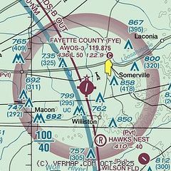
|
| Airport distance calculator |
|---|
|
|
| Sunrise and sunset |
|---|
|
Times for 22-Apr-2025
| | Local
(UTC-5) | | Zulu
(UTC) |
|---|
| Morning civil twilight | | 05:51 | | 10:51 |
| Sunrise | | 06:18 | | 11:18 |
| Sunset | | 19:35 | | 00:35 |
| Evening civil twilight | | 20:01 | | 01:01 |
|
| Current date and time |
|---|
| Zulu (UTC) | 23-Apr-2025 02:25:41 |
|---|
| Local (UTC-5) | 22-Apr-2025 21:25:41 |
|---|
|
| METAR |
|---|
| KFYE | 230155Z AUTO 00000KT 10SM CLR 19/14 A3003 RMK A01
|
KM08
17nm E | 230155Z AUTO 00000KT 10SM CLR 20/16 A3004 RMK A01
|
|
| TAF |
|---|
KMEM
30nm W | 222050Z 2221/2324 05007KT P6SM SCT050 FM230000 VRB03KT P6SM FEW250 PROB30 2309/2315 5SM -SHRA BKN035 FM231500 12005KT P6SM FEW250
|
KMKL
33nm NE | 221720Z 2218/2318 VRB03KT P6SM SCT250 FM230500 00000KT 6SM BR FEW250 TEMPO 2308/2312 1SM BR FM231400 12005KT P6SM FEW250
|
|
| NOTAMs |
|---|
NOTAMs are issued by the DoD/FAA and will open in a separate window not controlled by AirNav.
|
|


