FAA INFORMATION EFFECTIVE 17 APRIL 2025
Location
| FAA Identifier: | M08 |
| Lat/Long: | 35-12-54.5000N 089-02-35.7000W
35-12.908333N 089-02.595000W
35.2151389,-89.0432500
(estimated) |
| Elevation: | 499.1 ft. / 152.1 m (surveyed) |
| Variation: | 02W (2015) |
| From city: | 4 miles SW of BOLIVAR, TN |
| Time zone: | UTC -5 (UTC -6 during Standard Time) |
| Zip code: | 38008 |
Airport Operations
| Airport use: | Open to the public |
| Activation date: | 10/1967 |
| Control tower: | no |
| ARTCC: | MEMPHIS CENTER |
| FSS: | JACKSON FLIGHT SERVICE STATION |
| NOTAMs facility: | MKL (NOTAM-D service available) |
| Attendance: | MON-SAT 0830-1700, ALL SUN 1300-1700 |
| Wind indicator: | lighted |
| Segmented circle: | yes |
| Lights: | SS-SR |
| Beacon: | white-green (lighted land airport)
Operates sunset to sunrise. |
Airport Communications
| CTAF/UNICOM: | 123.0 |
| WX AWOS-3: | 121.125 (731-658-6436) |
| WX AWOS-3 at FYE (17 nm W): | 119.875 (901-465-6367) |
- APCH/DEP SVC PRVDD BY MEMPHIS ARTCC (ZME) ON FREQS 124.35/318.1 (MCKELLAR RCAG).
Nearby radio navigation aids
| VOR radial/distance | | VOR name | | Freq | | Var |
|---|
| MKLr197/24.2 | | MC KELLAR VOR/DME | | 114.85 | | 01W |
| HLIr037/34.8 | | HOLLY SPRINGS VORTAC | | 112.40 | | 03E |
Airport Services
| Fuel available: | 100LL JET-A |
| Parking: | hangars and tiedowns |
| Airframe service: | MAJOR |
| Powerplant service: | MAJOR |
Runway Information
Runway 1/19
| Dimensions: | 5007 x 75 ft. / 1526 x 23 m |
| Surface: | asphalt, in fair condition |
| Weight bearing capacity: | | PCN 11 /F/D/X/T | | Single wheel: | 29.5 | | Double wheel: | 40.0 |
|
| Runway edge lights: | medium intensity |
| RUNWAY 1 | | RUNWAY 19 |
| Latitude: | 35-12.498905N | | 35-13.318348N |
| Longitude: | 089-02.655955W | | 089-02.535272W |
| Elevation: | 499.0 ft. | | 493.0 ft. |
| Traffic pattern: | left | | left |
| Runway heading: | 008 magnetic, 006 true | | 188 magnetic, 186 true |
| Markings: | nonprecision, in fair condition | | nonprecision, in fair condition |
| Visual slope indicator: | 2-light PAPI on left (3.05 degrees glide path) | | 2-light PAPI on left (3.00 degrees glide path) |
| Runway end identifier lights: | yes | | yes |
| Touchdown point: | yes, no lights | | yes, no lights |
| Obstructions: | 43 ft. trees, 1043 ft. from runway, 34 ft. left of centerline, 19:1 slope to clear | | 66 ft. trees, 1534 ft. from runway, 378 ft. left of centerline, 20:1 slope to clear |
Airport Ownership and Management from official FAA records
| Ownership: | Publicly-owned |
| Owner: | HARDEMAN COUNTY
HARDEMAN COUNTY COURTHOUSE, BOX 250
BOLIVAR, TN 38009
Phone 731-658-3266 |
| Manager: | SHELBY W. ISHAM
800 AIRPORT RD
BOLIVAR, TN 38008
Phone 731-658-7556
AFT HR 731-658-4547. |
Additional Remarks
| - | FUEL SVC AVBL H24 WITH CREDIT CARD. |
| - | WILDLIFE INVOF ARPT. |
| - | FOR CD CTC MEMPHIS ARTCC AT 901-368-8453/8449. |
Instrument Procedures
NOTE: All procedures below are presented as PDF files. If you need a reader for these files, you should download the free Adobe Reader.NOT FOR NAVIGATION. Please procure official charts for flight.
FAA instrument procedures published for use from 17 April 2025 at 0901Z to 15 May 2025 at 0900z.
IAPs - Instrument Approach Procedures |
|---|
| RNAV (GPS) RWY 01 | |
download (228KB) |
| RNAV (GPS) RWY 19 | |
download (234KB) |
| NOTE: Special Take-Off Minimums/Departure Procedures apply | |
download (366KB) |
Other nearby airports with instrument procedures:
KFYE - Fayette County Airport (17 nm W)
KMKL - Jackson Regional Airport (24 nm N)
KSZY - Robert Sibley Airport (27 nm E)
KCRX - Roscoe Turner Airport (28 nm SE)
25M - Ripley Airport (30 nm S)
|
|

Road maps at:
MapQuest
Bing
Google
| Aerial photo |
|---|
WARNING: Photo may not be current or correct
 Photo by Joe Anderson
Photo taken 23-Feb-2013
looking northeast.
Photo by Joe Anderson
Photo taken 23-Feb-2013
looking northeast.
Do you have a better or more recent aerial photo of William L Whitehurst Field Airport that you would like to share? If so, please send us your photo.
|
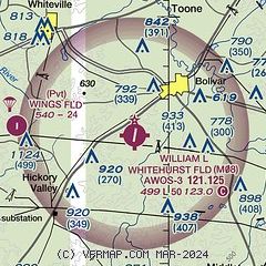
| Sectional chart |
|---|
|
| Airport distance calculator |
|---|
|
|
| Sunrise and sunset |
|---|
|
Times for 30-Apr-2025
| | Local
(UTC-5) | | Zulu
(UTC) |
|---|
| Morning civil twilight | | 05:40 | | 10:40 |
| Sunrise | | 06:07 | | 11:07 |
| Sunset | | 19:40 | | 00:40 |
| Evening civil twilight | | 20:07 | | 01:07 |
|
| Current date and time |
|---|
| Zulu (UTC) | 30-Apr-2025 13:55:13 |
|---|
| Local (UTC-5) | 30-Apr-2025 08:55:13 |
|---|
|
| METAR |
|---|
| KM08 | 301315Z AUTO VRB03KT 10SM CLR 22/20 A3007 RMK A01
|
KFYE
17nm W | 301315Z AUTO 19008KT 10SM CLR 23/19 A3005 RMK A01
|
|
| TAF |
|---|
KMKL
24nm N | 301129Z 3012/0112 16005KT P6SM SCT060 BKN200 FM301500 19009G18KT P6SM SCT045 BKN200 FM010000 18007KT P6SM FEW050 BKN250 FM010500 17010G19KT P6SM FEW060 OVC090 PROB30 0105/0110 6SM -SHRA
|
|
| NOTAMs |
|---|
NOTAMs are issued by the DoD/FAA and will open in a separate window not controlled by AirNav.
|
|


