FAA INFORMATION EFFECTIVE 17 APRIL 2025
Location
| FAA Identifier: | GGW |
| Lat/Long: | 48-12-44.8000N 106-36-53.3000W
48-12.746667N 106-36.888333W
48.2124444,-106.6148056
(estimated) |
| Elevation: | 2295.9 ft. / 699.8 m (surveyed) |
| Variation: | 11E (2010) |
| From city: | 1 mile NE of GLASGOW, MT |
| Time zone: | UTC -6 (UTC -7 during Standard Time) |
| Zip code: | 59230 |
Airport Operations
| Airport use: | Open to the public |
| Activation date: | 04/1940 |
| Control tower: | no |
| ARTCC: | SALT LAKE CITY CENTER |
| FSS: | GREAT FALLS FLIGHT SERVICE STATION |
| NOTAMs facility: | GGW (NOTAM-D service available) |
| Attendance: | 0600-2000 |
| Wind indicator: | lighted |
| Segmented circle: | yes |
| Lights: | ACTVT REIL RWY 8, 12, 26, & 30; MIRL RWY 08/26 & 12/30 - CTAF. PAPI RWY 08, 12, 26, & 30 OPR CONSLY. |
| Beacon: | white-green (lighted land airport)
Operates sunset to sunrise. |
Airport Communications
| CTAF/UNICOM: | 122.8 |
| WX ASOS: | 135.175 (406-224-4291) |
- APCH/DEP CTL SVC PRVDD BY SALT LAKE ARTCC ( ZLC) ON FREQS 126.85/305.2 (GLASGOW RCAG).
Nearby radio navigation aids
| VOR radial/distance | | VOR name | | Freq | | Var |
|---|
| GGW at field | | GLASGOW VOR/DME | | 113.90 | | 14E |
Airport Services
| Fuel available: | 100LL JET-A1+ |
| Parking: | hangars and tiedowns |
| Airframe service: | MAJOR |
| Powerplant service: | MAJOR |
| Bottled oxygen: | HIGH/LOW |
| Bulk oxygen: | HIGH/LOW |
Runway Information
Runway 12/30
| Dimensions: | 5002 x 100 ft. / 1525 x 30 m |
| Surface: | asphalt/grooved, in good condition |
| Weight bearing capacity: | | Single wheel: | 75.0 | | Double wheel: | 90.9 | | Double tandem: | 99.9 |
|
| Runway edge lights: | medium intensity |
| RUNWAY 12 | | RUNWAY 30 |
| Latitude: | 48-13.009873N | | 48-12.439410N |
| Longitude: | 106-37.351107W | | 106-36.464520W |
| Elevation: | 2290.9 ft. | | 2287.7 ft. |
| Traffic pattern: | left | | left |
| Runway heading: | 123 magnetic, 134 true | | 303 magnetic, 314 true |
| Declared distances: | TORA:5001 TODA:5001 ASDA:5001 LDA:5001 | | TORA:5001 TODA:5001 ASDA:5001 LDA:5001 |
| Markings: | nonprecision, in good condition | | nonprecision, in good condition |
| Visual slope indicator: | 4-light PAPI on left (3.00 degrees glide path) | | 4-light PAPI on left (3.00 degrees glide path) |
| Runway end identifier lights: | yes | | yes |
| Touchdown point: | yes, no lights | | yes, no lights |
Runway 8/26
| Dimensions: | 5000 x 75 ft. / 1524 x 23 m |
| Surface: | asphalt/grooved, in excellent condition |
| Weight bearing capacity: | | Single wheel: | 25.0 | | Double wheel: | 45.0 | | Double tandem: | 75.0 |
|
| Runway edge lights: | medium intensity |
| RUNWAY 8 | | RUNWAY 26 |
| Latitude: | 48-12.769063N | | 48-12.770678N |
| Longitude: | 106-37.482963W | | 106-36.252698W |
| Elevation: | 2284.2 ft. | | 2295.4 ft. |
| Traffic pattern: | left | | left |
| Runway heading: | 079 magnetic, 090 true | | 259 magnetic, 270 true |
| Declared distances: | TORA:5000 TODA:5000 ASDA:5000 LDA:5000 | | TORA:5000 TODA:5000 ASDA:5000 LDA:5000 |
| Markings: | basic, in fair condition | | basic, in good condition |
| Visual slope indicator: | 2-light PAPI on left (3.00 degrees glide path) | | 2-light PAPI on left (3.00 degrees glide path) |
| Runway end identifier lights: | yes | | yes |
| Touchdown point: | yes, no lights | | yes, no lights |
Airport Ownership and Management from official FAA records
| Ownership: | Publicly-owned |
| Owner: | GLASGOW VALLEY CO
89 AIRPORT RD
GLASGOW, MT 59230
Phone 406-228-2719 |
| Manager: | CORY WILLIAMS
89 AIRPORT RD
GLASGOW, MT 59230
Phone (406) 228-2719 |
Additional Remarks
| - | FOR CD IF UNA TO CTC ON FSS FREQ, CTC SALT LAKE ARTCC AT 801-320-2568. |
| - | SFC COND UNMON 2000-0600. |
Instrument Procedures
NOTE: All procedures below are presented as PDF files. If you need a reader for these files, you should download the free Adobe Reader.NOT FOR NAVIGATION. Please procure official charts for flight.
FAA instrument procedures published for use from 17 April 2025 at 0901Z to 15 May 2025 at 0900z.
IAPs - Instrument Approach Procedures |
|---|
| RNAV (GPS) RWY 12 | |
download (251KB) |
| RNAV (GPS) RWY 30 | |
download (251KB) |
| VOR RWY 12 | |
download (228KB) |
| VOR RWY 30 | |
download (216KB) |
| NOTE: Special Alternate Minimums apply | |
download (179KB) |
| NOTE: Special Take-Off Minimums/Departure Procedures apply | |
download (530KB) |
Other nearby airports with instrument procedures:
KOLF - L M Clayton Airport (42 nm E)
M75 - Malta Airport (53 nm W)
PO1 - Poplar Municipal Airport (58 nm E)
9S2 - Scobey Airport (59 nm NE)
4U6 - Circle Town County Airport (64 nm SE)
|
|

Road maps at:
MapQuest
Bing
Google
| Aerial photo |
|---|
WARNING: Photo may not be current or correct
 Photo by Mike Armstrong
Taken in July 2006
Photo by Mike Armstrong
Taken in July 2006
Do you have a better or more recent aerial photo of Wokal Field/Glasgow-Valley County Airport that you would like to share? If so, please send us your photo.
|
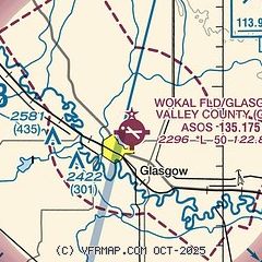
| Sectional chart |
|---|
|
| Airport distance calculator |
|---|
|
|
| Sunrise and sunset |
|---|
|
Times for 19-Apr-2025
| | Local
(UTC-6) | | Zulu
(UTC) |
|---|
| Morning civil twilight | | 05:37 | | 11:37 |
| Sunrise | | 06:10 | | 12:10 |
| Sunset | | 20:01 | | 02:01 |
| Evening civil twilight | | 20:35 | | 02:35 |
|
| Current date and time |
|---|
| Zulu (UTC) | 20-Apr-2025 05:08:59 |
|---|
| Local (UTC-6) | 19-Apr-2025 23:08:59 |
|---|
|
| METAR |
|---|
| KGGW | 200453Z AUTO 36022G31KT 10SM OVC095 11/M03 A2983 RMK AO2 PK WND 35033/0417 WSHFT 0345 SLP108 T01111028
|
|
| TAF |
|---|
| KGGW | 191727Z 1918/2018 19013KT P6SM SKC FM200000 VRB05KT P6SM SCT150 FM200400 35010KT P6SM SCT050 BKN080 FM200900 35009KT P6SM OVC025 PROB30 2010/2014 5SM -SHRA OVC015 FM201600 02008KT P6SM SCT015 BKN040
|
|
| NOTAMs |
|---|
NOTAMs are issued by the DoD/FAA and will open in a separate window not controlled by AirNav.
|
|


