FAA INFORMATION EFFECTIVE 17 APRIL 2025
Location
| FAA Identifier: | HRJ |
| Lat/Long: | 35-22-48.5580N 078-43-56.0520W
35-22.809300N 078-43.934200W
35.3801550,-78.7322367
(estimated) |
| Elevation: | 201.7 ft. / 61.5 m (surveyed) |
| Variation: | 08W (2000) |
| From city: | 4 miles NW of ERWIN, NC |
| Time zone: | UTC -4 (UTC -5 during Standard Time) |
| Zip code: | 28339 |
Airport Operations
| Airport use: | Open to the public |
| Activation date: | 09/1981 |
| Control tower: | no |
| ARTCC: | WASHINGTON CENTER |
| FSS: | RALEIGH FLIGHT SERVICE STATION |
| NOTAMs facility: | HRJ (NOTAM-D service available) |
| Attendance: | 0800-1700 |
| Wind indicator: | lighted |
| Segmented circle: | yes |
| Lights: | ACTVT REIL RWY 05 & RWY 23; MIRL RWY 05/23 - CTAF; PAPI RWY 05 & RWY 23 ON CONSLY. |
| Beacon: | white-green (lighted land airport)
Operates sunset to sunrise. |
Airport Communications
| CTAF/UNICOM: | 122.7 |
| WX AWOS-3: | 119.025 (910-814-3946) |
| FAYETTEVILLE APPROACH: | 125.175 |
| FAYETTEVILLE DEPARTURE: | 125.175 |
| CLASS C: | 125.175 |
| WX AWOS-3 at JNX (19 nm NE): | 120.225 (919-934-3851) |
Nearby radio navigation aids
| VOR radial/distance | | VOR name | | Freq | | Var |
|---|
| FAYr020/24.7 | | FAYETTEVILLE VOR/DME | | 114.85 | | 04W |
| RDUr184/29.6 | | RALEIGH/DURHAM VORTAC | | 117.20 | | 09W |
| NDB name | | Hdg/Dist | | Freq | | Var | | ID |
|---|
| HARNETT | | 230/4.2 | | 417 | | 08W | | HQT | .... --.- - |
| CLINTON | | 332/30.3 | | 412 | | 09W | | CTZ | -.-. - --.. |
Airport Services
| Fuel available: | 100LL JET-A1+
100LL:100LL 24 HR. SELF SVC WITH CREDIT CARD. |
| Parking: | hangars and tiedowns |
| Airframe service: | MAJOR |
| Powerplant service: | MAJOR |
| Bottled oxygen: | HIGH/LOW |
| Bulk oxygen: | NONE |
Runway Information
Runway 5/23
| Dimensions: | 5005 x 75 ft. / 1526 x 23 m |
| Surface: | asphalt, in excellent condition |
| Weight bearing capacity: | | Single wheel: | 45.0 | | Double wheel: | 60.0 |
|
| Runway edge lights: | medium intensity |
| RUNWAY 5 | | RUNWAY 23 |
| Latitude: | 35-22.493110N | | 35-23.125477N |
| Longitude: | 078-44.257573W | | 078-43.610775W |
| Elevation: | 187.9 ft. | | 201.7 ft. |
| Traffic pattern: | left | | left |
| Runway heading: | 048 magnetic, 040 true | | 228 magnetic, 220 true |
| Markings: | nonprecision, in good condition | | nonprecision, in good condition |
| Visual slope indicator: | 2-light PAPI on left (3.00 degrees glide path) | | 2-light PAPI on left (3.00 degrees glide path) |
| Runway end identifier lights: | yes | | yes |
| Touchdown point: | yes, no lights | | yes, no lights |
| Instrument approach: | LOC/DME | | |
| Obstructions: | none | | 96 ft. trees, 2593 ft. from runway, 172 ft. right of centerline, 24:1 slope to clear |
Airport Ownership and Management from official FAA records
| Ownership: | Publicly-owned |
| Owner: | HARNETT COUNTY
615 AIRPORT ROAD, 108 E. FRONT STREET
ERWIN, NC 28339
Phone 910-814-2740
COLEY PRICE, ASST COUNTY MGR. |
| Manager: | BRADLEY ABATE
615 AIRPORT RD
ERWIN, NC 28339
Phone 910-814-2740 |
Additional Remarks
| - | RWY 05, 60 FT DROP-OFF 350 FT FM THR & RWY 23, 25 FT DROP-OFF 70 FT LEFT OF CNTRLN. |
| - | FOR CD CTC FAYETTEVILLE APCH AT 910-484-8012. |
| - | SVC AVBL 24/7 WITH PRIOR ARNGMNTS. GPU AND BULK OIL AVBL. |
| - | ARPT LOCATED 18 NM NE OF POPE ARMY AIRFIELD, LOW LEVEL MIL ACT INVOF ARPT. |
| - | ROTG BCN OBSC BY TREES N & W OF ARPT. |
Instrument Procedures
NOTE: All procedures below are presented as PDF files. If you need a reader for these files, you should download the free Adobe Reader.NOT FOR NAVIGATION. Please procure official charts for flight.
FAA instrument procedures published for use from 17 April 2025 at 0901Z to 15 May 2025 at 0900z.
IAPs - Instrument Approach Procedures |
|---|
| RNAV (GPS) RWY 05 | |
download (207KB) |
| RNAV (GPS) RWY 23 | |
download (211KB) |
| LOC RWY 05 | |
download (233KB) |
| NDB RWY 23 | |
download (213KB) |
| NOTE: Special Alternate Minimums apply | |
download (66KB) |
| NOTE: Special Take-Off Minimums/Departure Procedures apply | |
download (141KB) |
Other nearby airports with instrument procedures:
KFBG - Simmons Army Airfield (18 nm SW)
KPOB - Pope Army Airfield (19 nm SW)
KJNX - Johnston Regional Airport (19 nm NE)
KTTA - Raleigh Executive Jetport at Sanford-Lee County Airport (22 nm NW)
KFAY - Fayetteville Regional Airport/Grannis Field (24 nm S)
|
|

Road maps at:
MapQuest
Bing
Google
| Aerial photo |
|---|
WARNING: Photo may not be current or correct
 Photo by Dan Clark, President, Executive Flight Training and Services LLC
Photo taken 12-May-2012
from 8,000' MSL looking west.
Photo by Dan Clark, President, Executive Flight Training and Services LLC
Photo taken 12-May-2012
from 8,000' MSL looking west.
Do you have a better or more recent aerial photo of Harnett Regional Jetport Airport that you would like to share? If so, please send us your photo.
|
| Sectional chart |
|---|
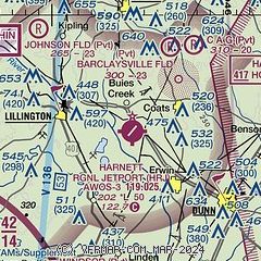
|
| Airport distance calculator |
|---|
|
|
| Sunrise and sunset |
|---|
|
Times for 22-Apr-2025
| | Local
(UTC-4) | | Zulu
(UTC) |
|---|
| Morning civil twilight | | 06:08 | | 10:08 |
| Sunrise | | 06:35 | | 10:35 |
| Sunset | | 19:52 | | 23:52 |
| Evening civil twilight | | 20:19 | | 00:19 |
|
| Current date and time |
|---|
| Zulu (UTC) | 22-Apr-2025 04:33:15 |
|---|
| Local (UTC-4) | 22-Apr-2025 00:33:15 |
|---|
|
| METAR |
|---|
| KHRJ | 220420Z AUTO 18005KT 10SM CLR 20/16 A3012 RMK AO2 T01970159
|
KFBG
18nm SW | 220355Z AUTO 19006KT 10SM CLR 22/16 A3010 RMK AO2 SLP194 T02170157 RVRNO $
|
KPOB
19nm SW | 220355Z AUTO 19010KT 10SM CLR 22/16 A3009 RMK AO2 SLP190 T02160157 $
|
KJNX
19nm NE | 220420Z AUTO 21006KT 10SM CLR 20/16 A3010 RMK AO2
|
|
| TAF |
|---|
KFBG
18nm SW | 220100Z 2201/2307 22006KT 9999 SKC QNH3008INS BECMG 2202/2203 24009KT 9999 FEW025 SCT050 QNH3009INS BECMG 2214/2215 24009KT 9999 SCT020 BKN040 QNH3012INS BECMG 2220/2221 28009KT 9000 -SHRA BKN035 QNH3004INS TX30/2220Z TN21/2211Z
|
KPOB
19nm SW | 220100Z 2201/2307 18009KT 9999 FEW050 BKN270 510102 QNH3005INS BECMG 2211/2212 22009KT 9999 SCT015 SCT035 SCT240 QNH3008INS BECMG 2215/2216 24010G16KT 9999 SCT035 BKN055 BKN240 QNH3001INS BECMG 2221/2222 26008KT 9999 VCTS SCT045CB BKN065 BKN220 QNH3001INS BECMG 2304/2305 VRB06KT 8000 -SHRA FEW008 BKN040 BKN080 BKN220 QNH3006INS TX29/2220Z TN17/2211Z LAST NO AMDS AFT 2202 NEXT 2217
|
|
| NOTAMs |
|---|
NOTAMs are issued by the DoD/FAA and will open in a separate window not controlled by AirNav.
|
|


