FAA INFORMATION EFFECTIVE 17 APRIL 2025
Location
| FAA Identifier: | JPX |
| Lat/Long: | 40-57-33.9000N 072-15-06.0000W
40-57.565000N 072-15.100000W
40.9594167,-72.2516667
(estimated) |
| Elevation: | 54.9 ft. / 16.7 m (surveyed) |
| Variation: | 13W (1980) |
| From city: | 3 miles W of EAST HAMPTON, NY |
| Time zone: | UTC -4 (UTC -5 during Standard Time) |
| Zip code: | 11963 |
Airport Operations
| Airport use: | Open to the public |
| Activation date: | 05/2022 |
| Control tower: | yes |
| ARTCC: | NEW YORK CENTER |
| FSS: | NEW YORK FLIGHT SERVICE STATION |
| NOTAMs facility: | JPX (NOTAM-D service available) |
| Attendance: | |
| Wind indicator: | lighted |
| Segmented circle: | yes |
| Lights: | ACTVT REIL RWY 28, MIRL RWY 10/28, TWY LGTS - CTAF. REIL RWY 10; PAPI RWY 10 & 28 OPR CONSLY. |
| Beacon: | white-green (lighted land airport)
Operates sunset to sunrise. |
| Landing fee: | yes, LNDG FEE FOR ALL ACFT TO INCL TGL OPNS. CTC 1-800-588-0028. |
Airport Communications
| CTAF: | 125.225 |
| WX AWOS-3PT: | 118.075 (631-537-2527) |
| EAST HAMPTON GROUND: | 121.9 [0800-2000; OPRS SAT BFR MEMORIAL DAY TO SUN AFT LABOR DAY.] |
| EAST HAMPTON TOWER: | 125.225 [0800-2000; OPRS SAT BFR MEMORIAL DAY TO SUN AFT LABOR DAY.] |
| NEW YORK APPROACH: | 125.975 |
| NEW YORK DEPARTURE: | 125.975 |
| CLEARANCE DELIVERY: | 118.95 |
| WX ASOS at FOK (19 nm W): | 119.925 (631-288-0588) |
Nearby radio navigation aids
| VOR radial/distance | | VOR name | | Freq | | Var |
|---|
| HTOr064/3.8 | | HAMPTON VORTAC | | 113.60 | | 13W |
| GONr216/24.0 | | GROTON VOR/DME | | 110.85 | | 14W |
| CCCr099/24.9 | | CALVERTON VOR/DME | | 114.55 | | 13W |
| MADr150/29.1 | | MADISON VOR/DME | | 110.40 | | 13W |
| SEYr263/33.0 | | SANDY POINT VOR/DME | | 117.80 | | 15W |
| ORWr212/37.6 | | NORWICH VOR/DME | | 110.00 | | 14W |
Airport Services
| Fuel available: | 100LL JET-A |
| Parking: | hangars and tiedowns |
| Airframe service: | MAJOR |
| Powerplant service: | MAJOR |
| Bottled oxygen: | NONE |
| Bulk oxygen: | NONE |
Runway Information
Runway 10/28
| Dimensions: | 4255 x 100 ft. / 1297 x 30 m |
| Surface: | asphalt/grooved, in good condition |
| Weight bearing capacity: | |
| Runway edge lights: | medium intensity |
| RUNWAY 10 | | RUNWAY 28 |
| Latitude: | 40-57.532960N | | 40-57.546103N |
| Longitude: | 072-15.618047W | | 072-14.693847W |
| Elevation: | 54.9 ft. | | 30.2 ft. |
| Traffic pattern: | left | | left |
| Runway heading: | 102 magnetic, 089 true | | 282 magnetic, 269 true |
| Markings: | nonprecision, in good condition | | nonprecision, in good condition |
| Visual slope indicator: | 2-light PAPI on left (3.30 degrees glide path) | | 2-light PAPI on right (3.80 degrees glide path) |
| Runway end identifier lights: | yes | | yes |
| Touchdown point: | yes, no lights | | yes, no lights |
| Obstructions: | 75 ft. trees, 1359 ft. from runway, 20 ft. right of centerline, 15:1 slope to clear | | 48 ft. pole, 282 ft. from runway, 254 ft. right of centerline, 1:1 slope to clear
+78 FT TREES, 850 FT FM THR BOTH SIDES CNTRLN; +15 FT ROAD, 491 FT FM THR BOTH SIDES CNTRLN. |
Runway 16/34
| Dimensions: | 2060 x 75 ft. / 628 x 23 m |
| Surface: | asphalt, in fair condition |
| Weight bearing capacity: | |
| RUNWAY 16 | | RUNWAY 34 |
| Latitude: | 40-57.763067N | | 40-57.471973N |
| Longitude: | 072-15.098043W | | 072-14.868170W |
| Elevation: | 40.7 ft. | | 29.8 ft. |
| Traffic pattern: | left | | left |
| Runway heading: | 162 magnetic, 149 true | | 342 magnetic, 329 true |
| Markings: | basic, in fair condition | | basic, in fair condition |
| Touchdown point: | yes, no lights | | yes, no lights |
| Obstructions: | 15 ft. road, 245 ft. from runway, 3:1 slope to clear | | 45 ft. trees, 699 ft. from runway, 11:1 slope to clear |
Airport Ownership and Management from official FAA records
| Ownership: | Publicly-owned |
| Owner: | TOWN OF EAST HAMPTON
159 PANTIGO RD
EAST HAMPTON, NY 11937
Phone 631-324-4140 |
| Manager: | JAMES BRUNDIGE
173 DANIELS HOLD RD
WAINSCOTT, NY 11975
Phone 631-537-1130
EXT 5. |
Additional Remarks
| - | DEER ON & INVOF ARPT. |
| - | REFER TO ARPT WEBSITE FOR DTLS ON CURRENT ARPT USAGE, RULES, NOISE ABMNT PCDRS AND REGS PRIOR TO ARR. |
| - | FOR CD WHEN ATCT CLSD CTC NEW YORK APCH AT 516-683-2449. |
| - | CTC FBO ON 122.85 FOR RAMP SVCS & PRKG. |
Instrument Procedures
NOTE: All procedures below are presented as PDF files. If you need a reader for these files, you should download the free Adobe Reader.NOT FOR NAVIGATION. Please procure official charts for flight.
FAA instrument procedures published for use from 17 April 2025 at 0901Z to 15 May 2025 at 0900z.
IAPs - Instrument Approach Procedures |
|---|
| RNAV (GPS) Z RWY 10 | |
download (287KB) |
| RNAV (GPS) Z RWY 28 | |
download (229KB) |
| NOTE: Special Alternate Minimums apply | |
download (144KB) |
| NOTE: Special Take-Off Minimums/Departure Procedures apply | |
download (452KB) |
Other nearby airports with instrument procedures:
87N - Southampton Heliport (12 nm SW)
KMTP - Montauk Airport (17 nm NE)
KFOK - Francis S Gabreski Airport (19 nm W)
0B8 - Elizabeth Field Airport (20 nm NE)
KGON - Groton-New London Airport (24 nm NE)
|
|

Road maps at:
MapQuest
Bing
Google
| Aerial photo |
|---|
WARNING: Photo may not be current or correct
 Photo courtesy of AirNav, LLC
Photo taken 30-Jul-2012
looking east.
Photo courtesy of AirNav, LLC
Photo taken 30-Jul-2012
looking east.
Do you have a better or more recent aerial photo of East Hampton Town Airport that you would like to share? If so, please send us your photo.
|
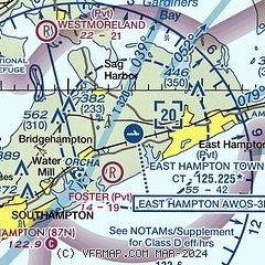
| Sectional chart |
|---|
|
CAUTION: Diagram may not be current

| Airport distance calculator |
|---|
|
|
| Sunrise and sunset |
|---|
|
Times for 21-Apr-2025
| | Local
(UTC-4) | | Zulu
(UTC) |
|---|
| Morning civil twilight | | 05:33 | | 09:33 |
| Sunrise | | 06:02 | | 10:02 |
| Sunset | | 19:34 | | 23:34 |
| Evening civil twilight | | 20:03 | | 00:03 |
|
| Current date and time |
|---|
| Zulu (UTC) | 22-Apr-2025 00:23:23 |
|---|
| Local (UTC-4) | 21-Apr-2025 20:23:23 |
|---|
|
| METAR |
|---|
| KJPX | 212355Z AUTO 15008KT 10SM OVC046 08/04 A3017 RMK AO2 T00800040 10102 20080
|
KMTP
16nm NE | 212354Z AUTO 15007KT 110V180 10/06 A3019 RMK AO1 SLP221 T01000056 10117 20100 56021
|
KFOK
18nm W | 212353Z VRB05KT 10SM OVC047 09/06 A3017 RMK AO2 SLP217 T00940061 10117 20094 56022
|
|
| TAF |
|---|
KGON
24nm N | 211943Z 2120/2218 15011KT P6SM BKN060 FM212100 16010KT P6SM BKN050 PROB30 2201/2204 -SHRA BKN030 FM220400 14005KT P6SM -SHRA BKN035 FM220600 15004KT 5SM -SHRA BR SCT004 BKN010 TEMPO 2207/2210 1SM BR BKN004 FM221000 20007KT 2SM BR BKN004 FM221500 23010KT P6SM BKN020
|
|
| NOTAMs |
|---|
NOTAMs are issued by the DoD/FAA and will open in a separate window not controlled by AirNav.
|
|


