FAA INFORMATION EFFECTIVE 17 APRIL 2025
Location
| FAA Identifier: | LRY |
| Lat/Long: | 38-36-36.7000N 094-20-36.7000W
38-36.611667N 094-20.611667W
38.6101944,-94.3435278
(estimated) |
| Elevation: | 915.4 ft. / 279.0 m (surveyed) |
| Variation: | 04E (1995) |
| From city: | 3 miles S of HARRISONVILLE, MO |
| Time zone: | UTC -5 (UTC -6 during Standard Time) |
| Zip code: | 64701 |
Airport Operations
| Airport use: | Open to the public |
| Activation date: | 06/1947 |
| Control tower: | no |
| ARTCC: | KANSAS CITY CENTER |
| FSS: | COLUMBIA FLIGHT SERVICE STATION |
| NOTAMs facility: | COU (NOTAM-D service available) |
| Attendance: | MON-FRI 0800-1700, ALL SAT-SUN IREG |
| Wind indicator: | lighted |
| Segmented circle: | yes |
| Lights: | ACTVT REIL RWY 17 & 35; PAPI RWY 17 & 35; MIRL RWY 17/35 - CTAF. |
| Beacon: | white-green (lighted land airport)
Operates sunset to sunrise. |
Airport Communications
| CTAF/UNICOM: | 123.0 |
| WX AWOS-3PT: | 119.975 (816-380-5936) |
- APCH/DEP SVC PRVDD BY KANSAS CITY ARTCC ON FREQS 125.55/327.0 (BUTLER RCAG).
Nearby radio navigation aids
| VOR radial/distance | | VOR name | | Freq | | Var |
|---|
| BUMr012/21.4 | | BUTLER VORTAC | | 115.90 | | 07E |
| ANXr192/30.8 | | NAPOLEON VORTAC | | 115.15 | | 07E |
Airport Services
| Fuel available: | 100LL
100LL:24-HR SELF SVC FUEL. |
| Parking: | tiedowns |
| Airframe service: | MINOR |
| Powerplant service: | MINOR |
| Bottled oxygen: | NONE |
| Bulk oxygen: | NONE |
Runway Information
Runway 17/35
| Dimensions: | 4000 x 75 ft. / 1219 x 23 m |
| Surface: | asphalt, in poor condition
RWY HAS EXTSV CRACKING. |
| Weight bearing capacity: | |
| Runway edge lights: | medium intensity |
| RUNWAY 17 | | RUNWAY 35 |
| Latitude: | 38-36.941060N | | 38-36.282938N |
| Longitude: | 094-20.632610W | | 094-20.590740W |
| Elevation: | 915.4 ft. | | 874.6 ft. |
| Traffic pattern: | left | | left |
| Runway heading: | 173 magnetic, 177 true | | 353 magnetic, 357 true |
| Declared distances: | TORA:4000 TODA:4000 ASDA:4000 LDA:4000 | | TORA:4000 TODA:4000 ASDA:4000 LDA:4000 |
| Markings: | nonprecision, in good condition | | nonprecision, in good condition |
| Visual slope indicator: | 2-light PAPI on left (4.00 degrees glide path) | | 2-light PAPI on left (3.00 degrees glide path) |
| Runway end identifier lights: | yes | | yes |
| Touchdown point: | yes, no lights | | yes, no lights |
| Obstructions: | 73 ft. trees, 1115 ft. from runway, 335 ft. left of centerline, 12:1 slope to clear | | 27 ft. trees, 340 ft. from runway, 200 ft. left of centerline, 5:1 slope to clear
RWY 35 SMALL TREES/BRUSH 7-10' TALL, 0-160' FROM RWY END AND 90-100' LEFT OF CNTRLN. |
Airport Ownership and Management from official FAA records
| Ownership: | Publicly-owned |
| Owner: | CITY OF HARRISONVILLE
PO BOX 367
HARRISONVILLE, MO 64701
Phone 816-380-8900 |
| Manager: | MICHAEL NEWMAN
PO BOX 367
HARRISONVILLE, MO 64701
Phone (660) 422-2090 |
Additional Remarks
| - | ULTRALIGHTS ON & INVOF ARPT. |
| - | AIR AMBULANCE HELICOPTER OPS ON AND INVOF ARPT. |
| - | FOR CD CTC KANSAS CITY APCH AT 816-329-2710. |
| - | DEER AND OTHER WILDFLIFE ON AND INVOF ARPT. |
Instrument Procedures
NOTE: All procedures below are presented as PDF files. If you need a reader for these files, you should download the free Adobe Reader.NOT FOR NAVIGATION. Please procure official charts for flight.
FAA instrument procedures published for use from 17 April 2025 at 0901Z to 15 May 2025 at 0900z.
IAPs - Instrument Approach Procedures |
|---|
| RNAV (GPS) RWY 17 **CHANGED** | |
download (213KB) |
| RNAV (GPS) RWY 35 | |
download (200KB) |
| NOTE: Special Alternate Minimums apply | |
download (133KB) |
| NOTE: Special Take-Off Minimums/Departure Procedures apply | |
download (421KB) |
Other nearby airports with instrument procedures:
KBUM - Butler Memorial Airport (19 nm S)
KLXT - Kansas City/Lee's Summit Regional Airport (21 nm N)
KOJC - Johnson County Executive Airport (23 nm NW)
3GV - East Kansas City Airport (25 nm N)
K81 - Miami County Airport (27 nm W)
|
|

Road maps at:
MapQuest
Bing
Google
| Aerial photo |
|---|
WARNING: Photo may not be current or correct
 Photo by Ryan Sparks
Photo taken 22-Mar-2019
looking north.
Photo by Ryan Sparks
Photo taken 22-Mar-2019
looking north.
Do you have a better or more recent aerial photo of Lawrence Smith Memorial Airport that you would like to share? If so, please send us your photo.
|
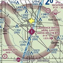
| Sectional chart |
|---|
|
| Airport distance calculator |
|---|
|
|
| Sunrise and sunset |
|---|
|
Times for 21-Apr-2025
| | Local
(UTC-5) | | Zulu
(UTC) |
|---|
| Morning civil twilight | | 06:06 | | 11:06 |
| Sunrise | | 06:34 | | 11:34 |
| Sunset | | 19:58 | | 00:58 |
| Evening civil twilight | | 20:26 | | 01:26 |
|
| Current date and time |
|---|
| Zulu (UTC) | 21-Apr-2025 13:59:46 |
|---|
| Local (UTC-5) | 21-Apr-2025 08:59:46 |
|---|
|
| METAR |
|---|
| KLRY | 211355Z AUTO 28007KT 10SM OVC014 11/07 A3010 RMK AO2
|
KGVW
17nm NW | 211335Z AUTO 1/2SM FG SCT003 BKN030 23/22 A3004 RMK A01
|
|
| TAF |
|---|
KIXD
28nm NW | 211120Z 2112/2212 26006KT P6SM SKC TEMPO 2112/2113 BKN015 FM211700 20009KT P6SM FEW250
|
KMKC
33nm N | 211120Z 2112/2212 28005KT P6SM OVC015 FM211330 20007KT P6SM SKC FM220800 19007KT P6SM FEW250
|
|
| NOTAMs |
|---|
NOTAMs are issued by the DoD/FAA and will open in a separate window not controlled by AirNav.
|
|


