FAA INFORMATION EFFECTIVE 20 FEBRUARY 2025
Location
| FAA Identifier: | MBT |
| Lat/Long: | 35-52-43.1700N 086-22-38.8950W
35-52.719500N 086-22.648250W
35.8786583,-86.3774708
(estimated) |
| Elevation: | 614.1 ft. / 187.2 m (surveyed) |
| Variation: | 02W (2000) |
| From city: | 2 miles N of MURFREESBORO, TN |
| Time zone: | UTC -6 (UTC -5 during Daylight Saving Time) |
| Zip code: | 37130 |
Airport Operations
| Airport use: | Open to the public |
| Activation date: | 07/1952 |
| Control tower: | no |
| ARTCC: | MEMPHIS CENTER |
| FSS: | NASHVILLE FLIGHT SERVICE STATION |
| NOTAMs facility: | BNA (NOTAM-D service available) |
| Attendance: | SUN 0700-1900, ALL MON-SAT 0700-1900
GEN ARPT INFO - 615-848-3254; EMERG OR AFT HR SVC - AMGR. |
| Wind indicator: | lighted |
| Segmented circle: | yes |
| Lights: | SS-SR |
| Beacon: | white-green (lighted land airport)
Operates sunset to sunrise. |
Airport Communications
| CTAF/UNICOM: | 123.075 |
| WX AWOS-3: | 133.975 (615-849-2622) |
| NASHVILLE APPROACH: | 118.4 |
| NASHVILLE DEPARTURE: | 118.4 |
| WX AWOS-3PT at MQY (10 nm NW): | 119.125 (615-223-7716) |
| WX AWOS-3 at M54 (19 nm N): | 118.325 (615-444-5778) |
| WX AWOS-3 at SYI (19 nm S): | 119.275 (931-685-4723) |
Nearby radio navigation aids
| VOR radial/distance | | VOR name | | Freq | | Var |
|---|
| SYIr010/19.2 | | SHELBYVILLE VOR/DME | | 113.55 | | 01W |
| BNAr138/21.5 | | NASHVILLE VORTAC | | 114.10 | | 02W |
| NDB name | | Hdg/Dist | | Freq | | Var | | ID |
|---|
| WALTER HILL | | 186/5.0 | | 371 | | 02W | | FQW | ..-. --.- .-- |
| HUCHN | | 263/39.0 | | 233 | | 03W | | HEM | .... . -- |
Airport Services
| Fuel available: | 100LL JET-A+ |
| Parking: | hangars and tiedowns |
| Airframe service: | MAJOR |
| Powerplant service: | MAJOR |
| Bottled oxygen: | LOW |
| Bulk oxygen: | LOW |
Runway Information
Runway 18/36
| Dimensions: | 4753 x 100 ft. / 1449 x 30 m |
| Surface: | asphalt, in good condition |
| Weight bearing capacity: | |
| Runway edge lights: | medium intensity |
| RUNWAY 18 | | RUNWAY 36 |
| Latitude: | 35-53.110833N | | 35-52.328167N |
| Longitude: | 086-22.627667W | | 086-22.668833W |
| Elevation: | 600.0 ft. | | 613.6 ft. |
| Traffic pattern: | left | | left |
| Runway heading: | 184 magnetic, 182 true | | 004 magnetic, 002 true |
| Markings: | nonprecision, in good condition | | nonprecision, in good condition |
| Visual slope indicator: | 2-light PAPI on left (3.00 degrees glide path) | | 2-light PAPI on left (3.75 degrees glide path) |
| Runway end identifier lights: | yes | | yes |
| Touchdown point: | yes, no lights | | yes, no lights |
| Obstructions: | 61 ft. tree, 1984 ft. from runway, 271 ft. right of centerline, 29:1 slope to clear | | 62 ft. tree, 1281 ft. from runway, 118 ft. right of centerline, 17:1 slope to clear |
Airport Ownership and Management from official FAA records
| Ownership: | Publicly-owned |
| Owner: | CITY OF MURFREESBORO
CITY HALL, 111 W VINE ST.
MURFREESBORO, TN 37130
Phone 615-893-5210 |
| Manager: | RYAN HULSEY
1930 MEMORIAL BLVD.
MURFREESBORO, TN 37129
Phone 615-217-5048 |
Additional Remarks
| A30A-36 | CALM WIND RWY. |
| - | STUDENT FLT TRNG 0800-1700. |
| - | GCO AVBL ON FREQ 135.075 THRU NASHVILLE CD. IF UNA FOR CD CTC NASHVILLE APCH 615-695-4522. |
| - | WILDLIFE INVOF ARPT. |
| - | ENGINE RUN-UP CONDUCTED E SIDE OF MAIN RAMP. |
| - | TRNG PAT CLSD 2200-0700 MON-FRI; WKEND & HOL 2200-0800; OTR TIMES PPR - AMGR. |
| - | NOISE ABATEMENT PROC IN EFCT; DEP CMB 2000 FT MSL BFR TURN. |
| - | OPDT PRACTICE APCHS NA. |
Instrument Procedures
NOTE: All procedures below are presented as PDF files. If you need a reader for these files, you should download the free Adobe Reader.NOT FOR NAVIGATION. Please procure official charts for flight.
FAA instrument procedures published for use from 20 February 2025 at 0901Z to 20 March 2025 at 0900Z.
IAPs - Instrument Approach Procedures |
|---|
| RNAV (GPS) RWY 18 | |
download (240KB) |
| RNAV (GPS) RWY 36 | |
download (219KB) |
| NOTE: Special Take-Off Minimums/Departure Procedures apply | |
download (237KB) |
Other nearby airports with instrument procedures:
KMQY - Smyrna Airport (10 nm NW)
M54 - Lebanon Municipal Airport (19 nm N)
KSYI - Bomar Field/Shelbyville Municipal Airport (19 nm S)
KBNA - Nashville International Airport (21 nm NW)
KRNC - Warren County Memorial Airport (28 nm E)
|
|

Road maps at:
MapQuest
Bing
Google
| Aerial photo |
|---|
WARNING: Photo may not be current or correct
 Photo taken 10-Jul-2017
looking south.
Photo taken 10-Jul-2017
looking south.
Do you have a better or more recent aerial photo of Murfreesboro Municipal Airport that you would like to share? If so, please send us your photo.
|
| Sectional chart |
|---|
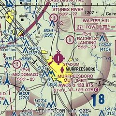
|
CAUTION: Diagram may not be current

| Airport distance calculator |
|---|
|
|
| Sunrise and sunset |
|---|
|
Times for 12-Mar-2025
| | Local
(UTC-6) | | Zulu
(UTC) |
|---|
| Morning civil twilight | | 05:36 | | 11:36 |
| Sunrise | | 06:02 | | 12:02 |
| Sunset | | 17:49 | | 23:49 |
| Evening civil twilight | | 18:15 | | 00:15 |
|
| Current date and time |
|---|
| Zulu (UTC) | 13-Mar-2025 03:27:02 |
|---|
| Local (UTC-6) | 12-Mar-2025 21:27:02 |
|---|
|
| METAR |
|---|
| KMBT | 130315Z AUTO 18006KT 10SM 17/00 A2983 RMK A01
|
KMQY
11nm NW | 130256Z 17005KT 10SM CLR 15/04 A2986 RMK AO2 SLP116 T01500039 51013
|
KM54
19nm N | 130300Z AUTO 19006KT 10SM BKN055 19/01 A2982 RMK A01
|
KSYI
19nm S | 130310Z AUTO 18006KT 10SM CLR 16/00 A2986 RMK A01
|
|
| TAF |
|---|
KMQY
11nm NW | 121723Z 1218/1318 22008KT P6SM SKC FM130400 19003KT P6SM BKN150 FM131300 20005KT P6SM BKN050
|
|
| NOTAMs |
|---|
NOTAMs are issued by the DoD/FAA and will open in a separate window not controlled by AirNav.
|
|


