FAA INFORMATION EFFECTIVE 20 FEBRUARY 2025
Location
| FAA Identifier: | MGG |
| Lat/Long: | 45-14-09.5740N 093-59-08.1200W
45-14.159567N 093-59.135333W
45.2359928,-93.9855889
(estimated) |
| Elevation: | 1028 ft. / 313.3 m (surveyed) |
| Variation: | 03E (2000) |
| From city: | 1 mile NE of MAPLE LAKE, MN |
| Time zone: | UTC -6 (UTC -5 during Daylight Saving Time) |
| Zip code: | 55358 |
Airport Operations
| Airport use: | Open to the public |
| Activation date: | 04/1966 |
| Control tower: | no |
| ARTCC: | MINNEAPOLIS CENTER |
| FSS: | PRINCETON FLIGHT SERVICE STATION |
| NOTAMs facility: | MGG (NOTAM-D service available) |
| Attendance: | UNATNDD |
| Wind indicator: | lighted |
| Segmented circle: | no |
| Lights: | SS-SR |
| Beacon: | white-green (lighted land airport)
Operates sunset to sunrise. |
Airport Communications
| CTAF/UNICOM: | 122.8 |
| WX AWOS-3: | 128.325 (320-963-3300) |
| MINNEAPOLIS APPROACH: | 126.5 |
| MINNEAPOLIS DEPARTURE: | 126.5 |
| WX AWOS-3PT at CFE (8 nm SE): | 120.45 (763-684-0762) |
| WX ASOS at STC (19 nm N): | 125.075 (320-240-8781) |
Nearby radio navigation aids
| VOR radial/distance | | VOR name | | Freq | | Var |
|---|
| STCr168/19.0 | | ST CLOUD VOR/DME | | 112.10 | | 03E |
| GEPr276/26.5 | | GOPHER VORTAC | | 117.30 | | 06E |
| FCMr316/33.7 | | FLYING CLOUD VOR/DME | | 117.70 | | 01E |
| MSPr301/37.7 | | MINNEAPOLIS VOR/DME | | 115.30 | | 02E |
| NDB name | | Hdg/Dist | | Freq | | Var | | ID |
|---|
| HUSSK | | 180/14.6 | | 342 | | 03E | | ST | ... - |
Airport Services
| Fuel available: | 100LL
100LL:FUEL AVBL H24 WITH CREDIT CARD. |
| Parking: | tiedowns |
| Airframe service: | NONE |
| Powerplant service: | NONE |
| Bottled oxygen: | NONE |
| Bulk oxygen: | NONE |
Runway Information
Runway 10/28
| Dimensions: | 2796 x 60 ft. / 852 x 18 m |
| Surface: | asphalt, in fair condition |
| Runway edge lights: | non-standard
NSTD LIRL DUE TO 400 FT SPACING BTN LGTS, 20 FT FM EDGE. |
| RUNWAY 10 | | RUNWAY 28 |
| Latitude: | 45-14.208167N | | 45-14.111283N |
| Longitude: | 093-59.453917W | | 093-58.817350W |
| Elevation: | 1024.0 ft. | | 1028.0 ft. |
| Traffic pattern: | left | | left |
| Runway heading: | 099 magnetic, 102 true | | 279 magnetic, 282 true |
| Displaced threshold: | 100 ft. | | no |
| Markings: | basic, in good condition | | basic, in good condition |
| Runway end identifier lights: | no | | no |
| Touchdown point: | yes, no lights | | yes, no lights |
| Obstructions: | 39 ft. pline, lighted, 535 ft. from runway, 143 ft. left of centerline, 8:1 slope to clear | | 40 ft. trees, 822 ft. from runway, 176 ft. right of centerline, 15:1 slope to clear
+8 FT RSG TRRN, 170 FT DIST, 80 FT R. |
Airport Ownership and Management from official FAA records
| Ownership: | Publicly-owned |
| Owner: | CITY OF MAPLE LAKE
PO BOX 757, 10 MAPLE AVE S
MAPLE LAKE, MN 55358
Phone 320-963-3611 |
| Manager: | GERALD SAWATZKE
PO BOX 757, 10 MAPLE AVE S
MAPLE LAKE, MN 55358
Phone 320-963-3738
OR 612-490-8459. |
Additional Remarks
| - | ONE TKOF/LDG PER FLT OPRN, NO TGL OR TRG. |
| - | MIGRATORY WATERFOWL ON & INVOF ARPT. |
| - | FOR CD CTC MINNEAPOLIS APCH AT 612-726-9086. |
Instrument Procedures
NOTE: All procedures below are presented as PDF files. If you need a reader for these files, you should download the free Adobe Reader.NOT FOR NAVIGATION. Please procure official charts for flight.
FAA instrument procedures published for use from 20 February 2025 at 0901Z to 20 March 2025 at 0900Z.
STARs - Standard Terminal Arrivals |
|---|
| AGUDE FIVE | |
download (220KB) |
IAPs - Instrument Approach Procedures |
|---|
| RNAV (GPS)-A | |
download (160KB) |
| NOTE: Special Alternate Minimums apply | |
download (175KB) |
Other nearby airports with instrument procedures:
KCFE - Buffalo Municipal Airport (8 nm SE)
KSTC - St Cloud Regional Airport (19 nm N)
KLJF - Litchfield Municipal Airport (24 nm W)
KPNM - Princeton Municipal Airport (25 nm NE)
KHCD - Hutchinson Municipal Airport-Butler Field (28 nm SW)
|
|

Road maps at:
MapQuest
Bing
Google
| Aerial photo |
|---|
WARNING: Photo may not be current or correct
 Photo taken 19-Feb-2011
looking southeast.
Photo taken 19-Feb-2011
looking southeast.
Do you have a better or more recent aerial photo of Maple Lake Municipal Airport-Bill Mavencamp Sr Field that you would like to share? If so, please send us your photo.
|
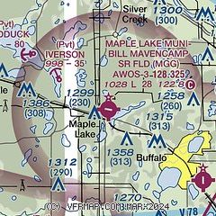
| Sectional chart |
|---|
|
| Airport distance calculator |
|---|
|
|
| Sunrise and sunset |
|---|
|
Times for 10-Mar-2025
| | Local
(UTC-6) | | Zulu
(UTC) |
|---|
| Morning civil twilight | | 06:09 | | 12:09 |
| Sunrise | | 06:39 | | 12:39 |
| Sunset | | 18:14 | | 00:14 |
| Evening civil twilight | | 18:43 | | 00:43 |
|
| Current date and time |
|---|
| Zulu (UTC) | 10-Mar-2025 11:40:25 |
|---|
| Local (UTC-6) | 10-Mar-2025 05:40:25 |
|---|
|
| METAR |
|---|
| KMGG | 101115Z AUTO 00000KT 10SM CLR 01/M02 A2967 RMK AO2 T00081023
|
KCFE
8nm SE | 101115Z AUTO 00000KT 10SM SCT034 BKN046 BKN055 M00/M00 A2967 RMK AO2
|
KSTC
19nm N | 101053Z AUTO 16003KT 10SM CLR 02/M03 A2965 RMK AO2 SLP053 T00171028 $
|
|
| TAF |
|---|
KSTC
19nm N | 100520Z 1006/1106 21005KT P6SM SCT250 FM101800 23012G21KT P6SM FEW250 FM102200 26015G26KT P6SM FEW250 FM110200 31017G34KT P6SM SCT200
|
|
| NOTAMs |
|---|
NOTAMs are issued by the DoD/FAA and will open in a separate window not controlled by AirNav.
|
|


