FAA INFORMATION EFFECTIVE 20 FEBRUARY 2025
Location
| FAA Identifier: | MRT |
| Lat/Long: | 40-13-28.1990N 083-21-05.8790W
40-13.469983N 083-21.097983W
40.2244997,-83.3516331
(estimated) |
| Elevation: | 1020.7 ft. / 311.1 m (surveyed) |
| Variation: | 05W (1985) |
| From city: | 1 mile SE of MARYSVILLE, OH |
| Time zone: | UTC -5 (UTC -4 during Daylight Saving Time) |
| Zip code: | 43040 |
Airport Operations
| Airport use: | Open to the public |
| Activation date: | 07/1967 |
| Control tower: | no |
| ARTCC: | INDIANAPOLIS CENTER |
| FSS: | DAYTON FLIGHT SERVICE STATION |
| NOTAMs facility: | DAY (NOTAM-D service available) |
| Attendance: | 0800-1700 |
| Wind indicator: | lighted |
| Segmented circle: | no |
| Lights: | ACTVT REIL RWY 09 & 27; PAPI RWY 09 & 27; MIRL RWY 09/27 - CTAF. |
| Beacon: | white-green (lighted land airport)
Operates sunset to sunrise. |
| Landing fee: | no, RAMP FEE FOR COML ACFT. |
Airport Communications
| CTAF/UNICOM: | 122.8 |
| WX AWOS-3: | 119.275 (937-644-2967) |
| COLUMBUS APPROACH: | 125.95 |
| COLUMBUS DEPARTURE: | 125.95 |
| IC: | 125.95 |
| WX AWOS-3 at DLZ (11 nm E): | 119.025 (740-203-1878) |
| WX ASOS at OSU (15 nm SE): | 121.35 (614-451-2465) |
| WX AWOS-3PT at UYF (18 nm S): | 120.85 (740-852-2844) |
| WX AWOS-3 at I74 (19 nm W): | 118.325 (937-484-5863) |
Nearby radio navigation aids
| VOR radial/distance | | VOR name | | Freq | | Var |
|---|
| BUDr214/(26.9) | | BUCKEYE VOR | | 109.80 | | 05W |
| RODr102/31.9 | | ROSEWOOD VORTAC | | 117.50 | | 05W |
| APEr283/35.3 | | APPLETON VORTAC | | 116.70 | | 06W |
| NDB name | | Hdg/Dist | | Freq | | Var | | ID |
|---|
| FULER | | 327/11.5 | | 515 | | 05W | | OS | --- ... |
| COURT HOUSE | | 009/37.5 | | 414 | | 06W | | CSS | -.-. ... ... |
Airport Services
| Fuel available: | 100LL JET-A1 JET-A1+
100LL:FUEL AVBL H24 SELF SVC VIA CREDIT CARD. |
| Parking: | hangars and tiedowns |
| Airframe service: | MAJOR |
| Powerplant service: | MAJOR |
| Bottled oxygen: | NONE |
| Bulk oxygen: | NONE |
Runway Information
Runway 9/27
| Dimensions: | 4218 x 75 ft. / 1286 x 23 m |
| Surface: | asphalt, in fair condition |
| Weight bearing capacity: | |
| Runway edge lights: | medium intensity |
| RUNWAY 9 | | RUNWAY 27 |
| Latitude: | 40-13.438457N | | 40-13.523258N |
| Longitude: | 083-21.546040W | | 083-20.646537W |
| Elevation: | 1020.6 ft. | | 996.8 ft. |
| Traffic pattern: | left | | left
CK NOTAMS FOR STS OF AEROBATIC BOX SOUTH OF RWY 09/27 & 08/26 - RP RWY 27 & 26 WHEN ACTV. |
| Runway heading: | 088 magnetic, 083 true | | 268 magnetic, 263 true |
| Displaced threshold: | no | | 123 ft. |
| Markings: | nonprecision, in good condition | | nonprecision, in good condition |
| Visual slope indicator: | 4-light PAPI on left (3.00 degrees glide path) | | 4-light PAPI on left (3.00 degrees glide path) |
| Runway end identifier lights: | yes | | yes |
| Touchdown point: | yes, no lights | | yes, no lights |
| Obstructions: | none | | 20 ft. rr, 425 ft. from runway, 260 ft. right of centerline, 11:1 slope to clear
APCH RATIO 27:1 TO DTHR DUE TO +20 FT RR, 425 FT DIST, 260 FT R. |
Runway 8/26
| Dimensions: | 2702 x 81 ft. / 824 x 25 m |
| Surface: | turf, in good condition |
| Runway edge markings: | THR & EDGES MKD WITH CONES. |
| RUNWAY 8 | | RUNWAY 26 |
| Latitude: | 40-13.425808N | | 40-13.480155N |
| Longitude: | 083-21.388715W | | 083-20.812545W |
| Elevation: | 1015.2 ft. | | 993.9 ft. |
| Traffic pattern: | left | | left |
| Runway heading: | 088 magnetic, 083 true | | 268 magnetic, 263 true |
| Runway end identifier lights: | no | | no |
| Touchdown point: | yes, no lights | | yes, no lights |
Airport Ownership and Management from official FAA records
| Ownership: | Publicly-owned |
| Owner: | UNION COUNTY ARPT AUTH
COUNTY COURTHOUSE, 215 W 5TH ST
MARYSVILLE, OH 43040
Phone 937-644-2055 |
| Manager: | DAVID HOLDEN
760 CLYMER RD
MARYSVILLE, OH 43040-9502
Phone 937-644-2055
AFT HRS & EMERG 937-741-3120. |
Additional Remarks
| A30A-09 | CALM WIND RWY. |
| - | DEER, BIRDS, & OTR WILDLIFE ON & INVOF ARPT. |
| - | FOR CD CTC COLUMBUS APCH AT 614-338-8537. |
Instrument Procedures
NOTE: All procedures below are presented as PDF files. If you need a reader for these files, you should download the free Adobe Reader.NOT FOR NAVIGATION. Please procure official charts for flight.
FAA instrument procedures published for use from 20 February 2025 at 0901Z to 20 March 2025 at 0900Z.
IAPs - Instrument Approach Procedures |
|---|
| RNAV (GPS) RWY 09 **CHANGED** | |
download (232KB) |
| RNAV (GPS) RWY 27 | |
download (217KB) |
| NOTE: Special Alternate Minimums apply | |
download (53KB) |
| NOTE: Special Take-Off Minimums/Departure Procedures apply | |
download (478KB) |
Other nearby airports with instrument procedures:
KDLZ - Delaware Municipal Airport - Jim Moore Field (11 nm E)
KOSU - Ohio State University Airport (15 nm SE)
KUYF - Madison County Airport (18 nm S)
I74 - Grimes Field Airport (19 nm W)
KTZR - Bolton Field Airport (22 nm SE)
|
|

Road maps at:
MapQuest
Bing
Google
| Aerial photo |
|---|
WARNING: Photo may not be current or correct
 Taken late December 2006
Do you have a better or more recent aerial photo of Union County Airport that you would like to share? If so, please send us your photo.
|
| Sectional chart |
|---|
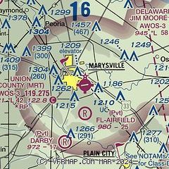
|
| Airport distance calculator |
|---|
|
|
| Sunrise and sunset |
|---|
|
Times for 11-Mar-2025
| | Local
(UTC-5) | | Zulu
(UTC) |
|---|
| Morning civil twilight | | 06:25 | | 11:25 |
| Sunrise | | 06:52 | | 11:52 |
| Sunset | | 18:35 | | 23:35 |
| Evening civil twilight | | 19:02 | | 00:02 |
|
| Current date and time |
|---|
| Zulu (UTC) | 11-Mar-2025 18:16:17 |
|---|
| Local (UTC-5) | 11-Mar-2025 13:16:17 |
|---|
|
| METAR |
|---|
| KMRT | 111755Z AUTO 30012KT 10SM CLR 20/03 A2972 RMK AO2 T01980029 10198 20051
|
KDLZ
11nm E | 111755Z AUTO 27009G15KT 10SM CLR 20/01 A2972 RMK AO2 PWINO
|
KOSU
15nm SE | 111753Z 27014G21KT 10SM CLR 23/01 A2971 RMK AO2 SLP060 T02280011 10228 20061 58008
|
KUYF
18nm S | 111755Z AUTO 28015G18KT 10SM CLR 20/M03 A2973 RMK AO2
|
KI74
19nm W | 111755Z AUTO 26009KT 10SM CLR 20/03 A2973 RMK AO2
|
|
| TAF |
|---|
KCMH
25nm SE | 111738Z 1118/1218 27010G18KT P6SM FEW250 FM112300 36007KT P6SM SCT040 FM120400 05009KT P6SM BKN040 FM121500 18007KT P6SM SCT040 BKN150
|
KLCK
32nm SE | 111738Z 1118/1218 24010G18KT P6SM FEW250 FM112300 27006KT P6SM FEW050 FM120500 15006KT P6SM FEW050 BKN150 FM121400 21008KT P6SM SCT050
|
|
| NOTAMs |
|---|
NOTAMs are issued by the DoD/FAA and will open in a separate window not controlled by AirNav.
|
|


