FAA INFORMATION EFFECTIVE 17 APRIL 2025
Location
| FAA Identifier: | OEO |
| Lat/Long: | 45-18-33.6350N 092-41-24.4421W
45-18.560583N 092-41.407368W
45.3093431,-92.6901228
(estimated) |
| Elevation: | 905.5 ft. / 276.0 m (surveyed) |
| Variation: | 01E (2000) |
| Time zone: | UTC -5 (UTC -6 during Standard Time) |
| Zip code: | 54020 |
Airport Operations
| Airport use: | Open to the public |
| Activation date: | 12/1948 |
| Control tower: | no |
| ARTCC: | MINNEAPOLIS CENTER |
| FSS: | GREEN BAY FLIGHT SERVICE STATION |
| NOTAMs facility: | OEO (NOTAM-D service available) |
| Attendance: | MON-FRI 0900-1600 |
| Wind indicator: | lighted |
| Segmented circle: | yes |
| Lights: | MIRL RWY 10/28 PRESET TO LOW SS-SR; TO INCR INTST AND ACTVT REIL RWY 28; PAPI RWY 10 & 28 - CTAF. |
| Beacon: | white-green (lighted land airport)
Operates sunset to sunrise. |
Airport Communications
| CTAF: | 122.9 |
| WX AWOS-3: | 119.925 (715-294-3845) |
| MINNEAPOLIS APPROACH: | 121.2 |
| MINNEAPOLIS DEPARTURE: | 121.2 |
| TWOLF STAR: | 126.95 |
| WX AWOS-3 at RNH (12 nm SE): | 120.0 (715-246-3202) |
| WX AWOS-3 at 21D (20 nm S): | 120.075 (651-779-5949) |
Nearby radio navigation aids
| VOR radial/distance | | VOR name | | Freq | | Var |
|---|
| GEPr065/30.5 | | GOPHER VORTAC | | 117.30 | | 06E |
| MSPr041/33.9 | | MINNEAPOLIS VOR/DME | | 115.30 | | 02E |
| NDB name | | Hdg/Dist | | Freq | | Var | | ID |
|---|
| BIG DOCTOR | | 205/33.6 | | 203 | | 01W | | BXR | -... -..- .-. |
Airport Services
| Fuel available: | 100LL JET-A+
100LL:SELF SVC FUEL AVBL 24 HRS. |
| Parking: | tiedowns |
| Airframe service: | MAJOR |
| Powerplant service: | MAJOR |
Runway Information
Runway 10/28
| Dimensions: | 5006 x 75 ft. / 1526 x 23 m |
| Surface: | asphalt, in good condition |
| Weight bearing capacity: | | Single wheel: | 20.0 | | Double wheel: | 30.0 |
|
| Runway edge lights: | medium intensity |
| RUNWAY 10 | | RUNWAY 28 |
| Latitude: | 45-18.590897N | | 45-18.394762N |
| Longitude: | 092-41.842145W | | 092-40.708393W |
| Elevation: | 884.2 ft. | | 905.5 ft. |
| Traffic pattern: | left | | left |
| Runway heading: | 103 magnetic, 104 true | | 283 magnetic, 284 true |
| Markings: | nonprecision, in good condition | | nonprecision, in good condition |
| Visual slope indicator: | 2-light PAPI on left (3.00 degrees glide path) | | 4-light PAPI on left (3.00 degrees glide path) |
| Runway end identifier lights: | no | | yes |
| Touchdown point: | yes, no lights | | yes, no lights |
| Obstructions: | 15 ft. road, 500 ft. from runway, 540 ft. right of centerline, 20:1 slope to clear | | none |
Runway 4/22
| Dimensions: | 2192 x 150 ft. / 668 x 46 m |
| Surface: | turf, in fair condition |
| Runway edge markings: | RWY 04/22 MKD WITH YELLOW CONES. |
| RUNWAY 4 | | RUNWAY 22 |
| Latitude: | 45-18.586183N | | 45-18.844453N |
| Longitude: | 092-41.887460W | | 092-41.530645W |
| Elevation: | 882.7 ft. | | 880.9 ft. |
| Traffic pattern: | left | | left |
| Runway heading: | 044 magnetic, 045 true | | 224 magnetic, 225 true |
| Markings: | none | | none |
| Runway end identifier lights: | no | | no |
| Touchdown point: | yes, no lights | | yes, no lights |
Airport Ownership and Management from official FAA records
| Ownership: | Publicly-owned |
| Owner: | VILLAGE OF OSCEOLA
PO BOX 217
OSCEOLA, WI 54020
Phone 715-294-3498 |
| Manager: | RICHARD JOHNSON
PO BOX 643
OSCEOLA, WI 54020
Phone 715-294-4500
EMAIL ADDRESS: RJOHNSON@OSCEOLAAERO.COM (ALL LOWER CASE) |
Additional Remarks
| - | RWY 04/22 CLSD TO WHEELED ACFT WHEN COVERED WITH SNOW OR ICE; OPEN TO SKI EQUIPPED ACFT WINTER MONTHS. CTC AMGR 612-308-0647. |
| - | GLIDER & ULTRALIGHT ACTIVITY ON & INVOF ARPT. |
| - | DEER & BIRDS ON & INVOF ARPT. |
| - | FOR CD CTC MINNEAPOLIS APCH AT 612-726-9086. |
| - | GCO AVBL ON FREQ 121.725 MSP CD & FLT SVCS. |
| - | AVOID OVERFLIGHT OF ST CROIX RIVER NATIONAL SCENIC BI-WAY BLW 2000 FT AGL EXC ON TAKEOFF OR LDG. |
Instrument Procedures
NOTE: All procedures below are presented as PDF files. If you need a reader for these files, you should download the free Adobe Reader.NOT FOR NAVIGATION. Please procure official charts for flight.
FAA instrument procedures published for use from 17 April 2025 at 0901Z to 15 May 2025 at 0900z.
STARs - Standard Terminal Arrivals |
|---|
| AGUDE FIVE | |
download (220KB) |
| TWOLF FOUR | |
download (169KB) |
IAPs - Instrument Approach Procedures |
|---|
| RNAV (GPS) RWY 10 | |
download (259KB) |
| RNAV (GPS) RWY 28 | |
download (259KB) |
| NOTE: Special Alternate Minimums apply | |
download (52KB) |
| NOTE: Special Take-Off Minimums/Departure Procedures apply | |
download (201KB) |
Other nearby airports with instrument procedures:
KRNH - New Richmond Regional Airport (12 nm SE)
KAHH - Amery Municipal Airport (13 nm E)
21D - Lake Elmo Airport (20 nm S)
KANE - Anoka County/Blaine Airport (Janes Field) (24 nm SW)
KROS - Rush City Regional Airport (26 nm NW)
|
|

Road maps at:
MapQuest
Bing
Google
| Aerial photo |
|---|
WARNING: Photo may not be current or correct

Do you have a better or more recent aerial photo of L O Simenstad Municipal Airport that you would like to share? If so, please send us your photo.
|
| Sectional chart |
|---|
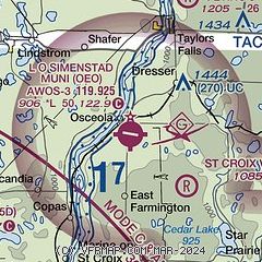
|
| Airport distance calculator |
|---|
|
|
| Sunrise and sunset |
|---|
|
Times for 20-Apr-2025
| | Local
(UTC-5) | | Zulu
(UTC) |
|---|
| Morning civil twilight | | 05:47 | | 10:47 |
| Sunrise | | 06:18 | | 11:18 |
| Sunset | | 20:02 | | 01:02 |
| Evening civil twilight | | 20:33 | | 01:33 |
|
| Current date and time |
|---|
| Zulu (UTC) | 21-Apr-2025 00:26:50 |
|---|
| Local (UTC-5) | 20-Apr-2025 19:26:50 |
|---|
|
| METAR |
|---|
| KOEO | 210015Z AUTO 12008KT 10SM SCT043 OVC050 08/06 A3007 RMK AO2 P0001 T00820060 PWINO
|
KRNH
12nm SE | 210010Z AUTO 10009KT 7SM RA SCT014 SCT021 OVC050 07/06 A3005 RMK AO2 P0002 T00700058
|
K21D
20nm S | 210015Z AUTO 09011G14KT 5SM RA SCT009 BKN014 OVC042 07/06 A3004 RMK AO2 P0002
|
|
| TAF |
|---|
KRNH
12nm SE | 201740Z 2018/2118 12008KT P6SM OVC150 FM202300 11009KT 4SM -RA BR OVC022 FM210300 08012G20KT 2SM -RA BR OVC008 FM210800 01012G21KT 2SM -RA BR OVC008 FM211100 34012G20KT 6SM -RA BR OVC007 FM211600 33014G22KT P6SM OVC012
|
|
| NOTAMs |
|---|
NOTAMs are issued by the DoD/FAA and will open in a separate window not controlled by AirNav.
|
|


