FAA INFORMATION EFFECTIVE 20 FEBRUARY 2025
Location
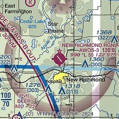
| FAA Identifier: | RNH |
| Lat/Long: | 45-08-52.0000N 092-32-21.0000W
45-08.866667N 092-32.350000W
45.1477778,-92.5391667
(estimated) |
| Elevation: | 997.9 ft. / 304.2 m (surveyed) |
| Variation: | 02E (1995) |
| From city: | 2 miles N of NEW RICHMOND, WI |
| Time zone: | UTC -6 (UTC -5 during Daylight Saving Time) |
| Zip code: | 54017 |
Airport Operations
| Airport use: | Open to the public |
| Activation date: | 07/1964 |
| Control tower: | no |
| ARTCC: | MINNEAPOLIS CENTER |
| FSS: | GREEN BAY FLIGHT SERVICE STATION |
| NOTAMs facility: | RNH (NOTAM-D service available) |
| Attendance: | CONTINUOUS |
| Wind indicator: | lighted |
| Segmented circle: | yes |
| Lights: | MIRL RWY 14/32 PRESET ON LOW INTST; TO INCR INTST & ACTVT REIL RWY 14 & 32; PAPI 14 & 32 - CTAF. |
| Beacon: | white-green (lighted land airport)
Operates sunset to sunrise. |
Airport Communications
| CTAF/UNICOM: | 122.975 |
| WX AWOS-3: | 120.0 (715-246-3202) |
| MINNEAPOLIS APPROACH: | 121.2 |
| MINNEAPOLIS DEPARTURE: | 121.2 |
| TWOLF STAR: | 126.95 |
| WX AWOS-3 at OEO (12 nm NW): | 119.925 (715-294-3845) |
| WX AWOS-3 at 21D (16 nm SW): | 120.075 (651-779-5949) |
Nearby radio navigation aids
| VOR radial/distance | | VOR name | | Freq | | Var |
|---|
| MSPr061/33.2 | | MINNEAPOLIS VOR/DME | | 115.30 | | 02E |
| GEPr084/35.3 | | GOPHER VORTAC | | 117.30 | | 06E |
Airport Services
| Fuel available: | 100LL JET-A |
| Parking: | hangars and tiedowns |
| Airframe service: | MAJOR |
| Powerplant service: | MAJOR |
| Bottled oxygen: | LOW |
| Bulk oxygen: | NONE |
Runway Information
Runway 14/32
| Dimensions: | 5507 x 75 ft. / 1679 x 23 m |
| Surface: | asphalt, in good condition |
| Weight bearing capacity: | | Single wheel: | 30.0 | | Double wheel: | 60.0 |
|
| Runway edge lights: | medium intensity |
| RUNWAY 14 | | RUNWAY 32 |
| Latitude: | 45-09.359745N | | 45-08.635575N |
| Longitude: | 092-32.773747W | | 092-32.003938W |
| Elevation: | 997.5 ft. | | 996.3 ft. |
| Traffic pattern: | left | | left |
| Runway heading: | 141 magnetic, 143 true | | 321 magnetic, 323 true |
| Markings: | nonprecision, in good condition | | nonprecision, in good condition |
| Visual slope indicator: | 4-light PAPI on left (3.00 degrees glide path) | | 4-light PAPI on left (3.00 degrees glide path)
PAPI RWY 32 UNUSBL BYD 4 DEG R OF COURSE. |
| Runway end identifier lights: | yes | | yes |
| Touchdown point: | yes, no lights | | yes, no lights |
| Obstructions: | 54 ft. tree, 1500 ft. from runway, 230 ft. left of centerline, 24:1 slope to clear | | none |
Helipad H1
| Dimensions: | 40 x 40 ft. / 12 x 12 m |
| Surface: | asphalt, in fair condition |
| Latitude: | 45-09.098167N | | |
| Longitude: | 092-32.591667W | | |
| Elevation: | 994.0 ft. | | |
| Traffic pattern: | left | | left |
Runway 4/22
| Dimensions: | 2050 x 75 ft. / 625 x 23 m |
| Surface: | turf, in fair condition |
| Operational restrictions: | MARKED WITH WHITE CONES. OPEN TO SKI EQUIPPED ACFT WINTER MONTHS. |
| RUNWAY 4 | | RUNWAY 22 |
| Latitude: | 45-08.389978N | | 45-08.633430N |
| Longitude: | 092-32.409538W | | 092-32.079705W |
| Elevation: | 989.9 ft. | | 993.1 ft. |
| Traffic pattern: | left | | left |
| Runway heading: | 042 magnetic, 044 true | | 222 magnetic, 224 true |
| Markings: | none | | none |
| Runway end identifier lights: | no | | no |
| Touchdown point: | yes, no lights | | yes, no lights |
Airport Ownership and Management from official FAA records
| Ownership: | Publicly-owned |
| Owner: | CITY OF NEW RICHMOND
156 E FIRST ST
NEW RICHMOND, WI 54017
Phone 715-246-4268 |
| Manager: | MIKE DEMULLING
156 E FIRST STREET
NEW RICHMOND, WI 54017
Phone 715-246-7735
EMAIL ADDRESS: MIKE@NRAIRPORT.COM (ALL LOWER CASE) |
Additional Remarks
| - | GCO AVBL ON FREQ 121.725 THRU MINNEAPOLIS APCH CTL. |
| - | AUTOMOBILE AND PEDESTRIAN ACCESS ONTO ARPT PROPERTY RESTRICTED BY SECURITY FENCING AND GATES FM 2200-0600. CTC AMGR 715-246-7735 FOR ACCESS INSTRUCTIONS. |
| - | 24-HR SELF SVC FUEL AVBL FOR CREDIT CARD USERS OR CALL 715-246-5338. |
| - | FOR CD CTC MINNEAPOLIS APCH AT 612-726-9086. |
| - | DEER & BIRDS ON & INVOF ARPT. |
| - | AEROBATIC PRACTICE AREA 4 NM NE OF ARPT. |
| - | ULTRALIGHT ACTIVITY ON & INVOF ARPT. |
| - | SEAPLANE TRAFFIC ADJACENT TO SOUTH SIDE OF ARPT. |
| - | TURBO-JET TOUCH & GO NOT AUTHORIZED. |
| - | BRIGHT LGTS FM BALL FIELDS 1/2 MI SOUTH DURG EVENINGS MAY THRU SEP. |
Instrument Procedures
NOTE: All procedures below are presented as PDF files. If you need a reader for these files, you should download the free Adobe Reader.NOT FOR NAVIGATION. Please procure official charts for flight.
FAA instrument procedures published for use from 20 February 2025 at 0901Z to 20 March 2025 at 0900Z.
STARs - Standard Terminal Arrivals |
|---|
| AGUDE FIVE | |
download (220KB) |
| TWOLF FOUR | |
download (169KB) |
IAPs - Instrument Approach Procedures |
|---|
| RNAV (GPS) RWY 14 | |
download (238KB) |
| RNAV (GPS) RWY 32 | |
download (270KB) |
| NOTE: Special Alternate Minimums apply | |
download (27KB) |
| NOTE: Special Take-Off Minimums/Departure Procedures apply | |
download (233KB) |
Other nearby airports with instrument procedures:
KAHH - Amery Municipal Airport (11 nm NE)
KOEO - L O Simenstad Municipal Airport (12 nm NW)
21D - Lake Elmo Airport (16 nm SW)
3T3 - Boyceville Municipal Airport (23 nm E)
KSTP - St Paul Downtown Airport Holman Field (26 nm SW)
|
|

Road maps at:
MapQuest
Bing
Google
| Aerial photo |
|---|
WARNING: Photo may not be current or correct
 Photo taken 06-Jul-2017
looking south.
Photo taken 06-Jul-2017
looking south.
Do you have a better or more recent aerial photo of New Richmond Regional Airport that you would like to share? If so, please send us your photo.
|
| Sectional chart |
|---|
|
CAUTION: Diagram may not be current

| Airport distance calculator |
|---|
|
|
| Sunrise and sunset |
|---|
|
Times for 06-Mar-2025
| | Local
(UTC-6) | | Zulu
(UTC) |
|---|
| Morning civil twilight | | 06:11 | | 12:11 |
| Sunrise | | 06:40 | | 12:40 |
| Sunset | | 18:03 | | 00:03 |
| Evening civil twilight | | 18:32 | | 00:32 |
|
| Current date and time |
|---|
| Zulu (UTC) | 06-Mar-2025 23:18:34 |
|---|
| Local (UTC-6) | 06-Mar-2025 17:18:34 |
|---|
|
| METAR |
|---|
| KRNH | 062255Z AUTO 32012KT 10SM OVC050 02/M03 A2984 RMK AO2 T00221034
|
KOEO
11nm NW | 062255Z AUTO 33005KT 10SM CLR 03/M05 A2987 RMK AO2 T00331047 PWINO
|
K21D
16nm SW | 062255Z AUTO 28007KT 10SM OVC043 03/M03 A2985 RMK AO2
|
|
| TAF |
|---|
| KRNH | 061720Z 0618/0718 25008KT P6SM FEW070 FM062000 28010KT P6SM FEW070 FEW250 FM070000 27005KT P6SM FEW250 FM070600 VRB03KT P6SM SCT250
|
|
| NOTAMs |
|---|
NOTAMs are issued by the DoD/FAA and will open in a separate window not controlled by AirNav.
|
|


