FAA INFORMATION EFFECTIVE 17 APRIL 2025
Location
| FAA Identifier: | PPO |
| Lat/Long: | 41-34-20.8810N 086-44-04.3000W
41-34.348017N 086-44.071667W
41.5724669,-86.7345278
(estimated) |
| Elevation: | 812 ft. / 247.5 m (surveyed) |
| Variation: | 03W (1995) |
| From city: | 3 miles S of LA PORTE, IN |
| Time zone: | UTC -5 (UTC -6 during Standard Time) |
| Zip code: | 46350 |
Airport Operations
| Airport use: | Open to the public |
| Activation date: | 04/1940 |
| Control tower: | no |
| ARTCC: | CHICAGO CENTER |
| FSS: | TERRE HAUTE FLIGHT SERVICE STATION |
| NOTAMs facility: | HUF (NOTAM-D service available) |
| Attendance: | MON-FRI 0700-1700, ALL SAT-SUN 0800-1700 |
| Wind indicator: | lighted |
| Segmented circle: | yes |
| Lights: | ACTVT REIL RWY 02, 14, 20, & 32; PAPI RWY 02, 20, & 32; MIRL RWY 02/20 & 14/32 - CTAF. |
| Beacon: | white-green (lighted land airport)
Operates sunset to sunrise. |
Airport Communications
| CTAF/UNICOM: | 123.0 |
| WX AWOS-3PT: | 119.825 (219-326-6916) |
| SOUTH BEND APPROACH: | 132.05 |
| SOUTH BEND DEPARTURE: | 132.05 |
| WX AWOS-3 at MGC (9 nm NW): | 128.450 (219-878-1106) |
| WX ASOS at VPZ (14 nm SW): | 125.875 (219-531-1770) |
| WX AWOS-3 at OXI (15 nm S): | 135.775 (574-772-2041) |
- APCH/DEP SVC PRVDD BY CHICAGO ARTCC ON FREQS 135.9/314.0 (GOSHEN RCAG) WHEN SOUTH BEND APCH CTL CLSD.
Nearby radio navigation aids
| VOR radial/distance | | VOR name | | Freq | | Var |
|---|
| GIJr238/22.1 | | GIPPER VORTAC | | 115.40 | | 00E |
| GSHr275/31.9 | | GOSHEN VORTAC | | 113.70 | | 00E |
| CGTr082/37.8 | | CHICAGO HEIGHTS VORTAC | | 114.20 | | 02E |
| NDB name | | Hdg/Dist | | Freq | | Var | | ID |
|---|
| SEDLY | | 043/9.7 | | 212 | | 02W | | VP | ...- .--. |
Airport Services
| Fuel available: | 100LL JET-A MOGAS
100LL:TRML FUEL AVBL DURG ATND HR OR SVC CALL. SELF SERVE FUEL H24 E SIDE. |
| Parking: | hangars and tiedowns |
| Airframe service: | MINOR |
| Powerplant service: | MINOR |
Runway Information
Runway 2/20
| Dimensions: | 5000 x 75 ft. / 1524 x 23 m |
| Surface: | asphalt/grooved, in good condition |
| Weight bearing capacity: | |
| Runway edge lights: | medium intensity |
| RUNWAY 2 | | RUNWAY 20 |
| Latitude: | 41-33.932682N | | 41-34.705827N |
| Longitude: | 086-44.258860W | | 086-43.881975W |
| Elevation: | 800.3 ft. | | 811.9 ft. |
| Traffic pattern: | left | | left |
| Runway heading: | 023 magnetic, 020 true | | 203 magnetic, 200 true |
| Markings: | nonprecision, in good condition | | nonprecision, in good condition |
| Visual slope indicator: | 2-light PAPI on left (3.00 degrees glide path) | | 2-light PAPI on left (3.45 degrees glide path) |
| Runway end identifier lights: | yes | | yes |
| Touchdown point: | yes, no lights | | yes, no lights |
| Instrument approach: | LOCALIZER | | |
| Obstructions: | 10 ft. crops, 201 ft. from runway, 240 ft. right of centerline | | 10 ft. crops, 201 ft. from runway, 160 ft. left of centerline
10 FT CROPS 160 FT L OF RWY END. |
Runway 14/32
| Dimensions: | 2797 x 60 ft. / 853 x 18 m |
| Surface: | asphalt, in good condition |
| Runway edge lights: | medium intensity |
| RUNWAY 14 | | RUNWAY 32 |
| Latitude: | 41-34.562115N | | 41-34.236767N |
| Longitude: | 086-44.290982W | | 086-43.856815W |
| Elevation: | 810.0 ft. | | 799.3 ft. |
| Traffic pattern: | left | | left |
| Runway heading: | 138 magnetic, 135 true | | 318 magnetic, 315 true |
| Displaced threshold: | 199 ft. | | 198 ft. |
| Markings: | basic, in good condition | | basic, in good condition |
| Visual slope indicator: | | | 2-light PAPI on left (3.50 degrees glide path)
UNUSBL BYD 2 DEGS LEFT OF CNTRLN. |
| Runway end identifier lights: | yes | | yes |
| Touchdown point: | yes, no lights | | yes, no lights |
| Obstructions: | 10 ft. crops, 201 ft. from runway
10 FT CROPS 80 FT FM RWY END 75 FT R & 150 FT L. | | 10 ft. crops, 201 ft. from runway
CLOSEST INTCP POINT. |
Airport Ownership and Management from official FAA records
| Ownership: | Publicly-owned |
| Owner: | LA PORTE ARPT AUTH
2341 STATE RD 39S
LA PORTE, IN 46350
Phone 219-324-3393
EDWARD VOLK |
| Manager: | ERIC BOBCEK
2341 STATE RD 39S
LA PORTE, IN 46350
Phone 219-324-3393 |
Additional Remarks
| - | FARM EQUIP ON OR NEAR OPS AREAS. |
| - | TWY LGTS AT TWY ENTRANCE ONLY. |
| - | FOR CD CTC SOUTH BEND APCH AT 574-251-2609. WHEN SOUTH BEND APCH CLSD, FOR CD CTC CHICAGO ARTCC AT 630-906-8921. |
| - | SVC AFT HR - 219-608-4707 OR 219-363-6659. |
Instrument Procedures
NOTE: All procedures below are presented as PDF files. If you need a reader for these files, you should download the free Adobe Reader.NOT FOR NAVIGATION. Please procure official charts for flight.
FAA instrument procedures published for use from 17 April 2025 at 0901Z to 15 May 2025 at 0900z.
IAPs - Instrument Approach Procedures |
|---|
| RNAV (GPS) RWY 02 **CHANGED** | |
download (270KB) |
| RNAV (GPS) RWY 20 **CHANGED** | |
download (253KB) |
| NOTE: Special Alternate Minimums apply **CHANGED** | |
download (169KB) |
| NOTE: Special Take-Off Minimums/Departure Procedures apply | |
download (164KB) |
Other nearby airports with instrument procedures:
KMGC - Michigan City Municipal Airport-Phillips Field (9 nm NW)
KVPZ - Porter County Regional Airport (14 nm SW)
KOXI - Starke County Airport (15 nm S)
KSBN - South Bend International Airport (20 nm NE)
C65 - Plymouth Municipal Airport (23 nm SE)
|
|

Road maps at:
MapQuest
Bing
Google
| Aerial photo |
|---|
WARNING: Photo may not be current or correct
 Photo taken 01-Jan-2007
looking north.
Photo taken 01-Jan-2007
looking north.
Do you have a better or more recent aerial photo of La Porte Municipal Airport that you would like to share? If so, please send us your photo.
|
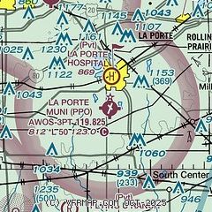
| Sectional chart |
|---|
|
CAUTION: Diagram may not be current

| Airport distance calculator |
|---|
|
|
| Sunrise and sunset |
|---|
|
Times for 20-Apr-2025
| | Local
(UTC-5) | | Zulu
(UTC) |
|---|
| Morning civil twilight | | 05:31 | | 10:31 |
| Sunrise | | 06:00 | | 11:00 |
| Sunset | | 19:31 | | 00:31 |
| Evening civil twilight | | 20:01 | | 01:01 |
|
| Current date and time |
|---|
| Zulu (UTC) | 21-Apr-2025 01:33:32 |
|---|
| Local (UTC-5) | 20-Apr-2025 20:33:32 |
|---|
|
| METAR |
|---|
| KPPO | 210115Z AUTO 10017G25KT 10SM FEW120 15/06 A2997 RMK AO2 PK WND 09029/00 PRESFR
|
KMGC
9nm NW | 210115Z AUTO 11013G23KT 10SM CLR 14/03 A2996 RMK AO2
|
KVPZ
14nm SW | 210056Z AUTO 11017G25KT 10SM CLR 16/07 A2995 RMK AO2 PK WND 12028/0043 SLP142 T01610067
|
KOXI
15nm S | 210115Z AUTO 11021G26KT 10SM CLR 15/01 A2995 RMK AO1
|
|
| TAF |
|---|
KSBN
20nm E | 201720Z 2018/2118 12018G25KT P6SM BKN090 FM210800 15016G24KT P6SM VCSH BKN025 FM211200 22019G27KT P6SM OVC020
|
|
| NOTAMs |
|---|
NOTAMs are issued by the DoD/FAA and will open in a separate window not controlled by AirNav.
|
|


