FAA INFORMATION EFFECTIVE 20 FEBRUARY 2025
Location
| FAA Identifier: | SEE |
| Lat/Long: | 32-49-34.4000N 116-58-20.8000W
32-49.573333N 116-58.346667W
32.8262222,-116.9724444
(estimated) |
| Elevation: | 387.5 ft. / 118.1 m (surveyed) |
| Variation: | 13E (1990) |
| From city: | 10 miles NE of central business district of the associated city |
| Time zone: | UTC -8 (UTC -7 during Daylight Saving Time) |
| Zip code: | 92020 |
Airport Operations
| Airport use: | Open to the public |
| Activation date: | 12/1942 |
| Control tower: | yes |
| ARTCC: | LOS ANGELES CENTER |
| FSS: | SAN DIEGO FLIGHT SERVICE STATION |
| NOTAMs facility: | SEE (NOTAM-D service available) |
| Attendance: | 0700-2100 |
| Wind indicator: | lighted |
| Segmented circle: | no |
| Lights: | WHEN ATCT CLSD ACTVT REIL RWY 27R; PAPI RWY 09L & 27R; VASI RWY 17 & 35; MIRL RWY 09L/27R & RWY 17/35 - CTAF. |
| Beacon: | white-green (lighted land airport)
Operates sunset to sunrise. |
Airport Communications
| CTAF: | 120.7 |
| ATIS: | 125.45 |
| WX AWOS-3P: | 125.45 (619-449-1228) |
| GILLESPIE GROUND: | 121.7 [0700-2100] |
| GILLESPIE TOWER: | 120.7 257.8 123.8 [0700-2100] |
| SOCAL APPROACH: | 124.35 |
| SOCAL DEPARTURE: | 124.35 |
| CLEARANCE DELIVERY: | 125.1 |
| CLASS B: | 124.35 ;062-109 SAN 14,000 FT & BLW 132.2 ;029-061 SAN 14,000 FT & BLW 132.2 ;333-028 SAN 7,000 FT-11,000 F |
| CWARD DP: | 119.6 |
| PADRZ DP: | 119.6 |
| WX ASOS at MYF (8 nm W): | 126.9 (858-576-4337) |
| WX ASOS at SAN (12 nm SW): | PHONE 619-296-8934 |
| WX ASOS at RNM (13 nm N): | PHONE 760-789-7699 |
| WX ASOS at SDM (15 nm S): | 132.35 (619-661-8297) |
| WX ASOS at NRS (17 nm SW): | PHONE 619-437-9890 |
- GENERAL OUTLOOK ON ATIS WHEN ATCT CLSD.
Nearby radio navigation aids
| VOR radial/distance | | VOR name | | Freq | | Var |
|---|
| PGYr347/13.0 | | POGGI VORTAC | | 116.45 | | 14E |
| MZBr063/13.0 | | MISSION BAY VORTAC | | 117.80 | | 15E |
| TIJr345/17.2 | | TIJUANA VOR/DME | | 116.50 | | 12E |
| JLIr211/27.1 | | JULIAN VORTAC | | 114.00 | | 15E |
| OCNr123/33.5 | | OCEANSIDE VORTAC | | 115.30 | | 15E |
Airport Services
| Fuel available: | 100LL JET-A
100LL:FOR FUEL SVC OR ASSISTANCE DRG BUS HRS, CTC (619) 449-0611, (619) 448-5991, OR (619) 981-5000. 100LL SELF SVC AVBL 24 HRS. |
| Parking: | tiedowns |
| Airframe service: | MAJOR |
| Powerplant service: | MAJOR |
| Bottled oxygen: | HIGH/LOW |
| Bulk oxygen: | HIGH/LOW |
Runway Information
Runway 9L/27R
| Dimensions: | 5342 x 100 ft. / 1628 x 30 m |
| Surface: | asphalt, in good condition |
| Weight bearing capacity: | | Single wheel: | 90.0 | | Double wheel: | 120.0 | | Double tandem: | 200.0 |
|
| Runway edge lights: | medium intensity |
| RUNWAY 9L | | RUNWAY 27R |
| Latitude: | 32-49.767562N | | 32-49.583215N |
| Longitude: | 116-58.875063W | | 116-57.854818W |
| Elevation: | 359.1 ft. | | 387.5 ft. |
| Traffic pattern: | left | | right |
| Runway heading: | 089 magnetic, 102 true | | 269 magnetic, 282 true |
| Displaced threshold: | no | | 706 ft. |
| Markings: | nonprecision, in good condition | | nonprecision, in good condition |
| Visual slope indicator: | 4-light PAPI on right (3.75 degrees glide path) | | 4-light PAPI on left (4.50 degrees glide path)
PAPI UNUSBL BYD 6 DEGS RIGHT OF CRS. |
| Runway end identifier lights: | | | yes |
| Touchdown point: | yes, no lights | | yes, no lights |
| Instrument approach: | | | LOC/DME |
| Obstructions: | 87 ft. tree, 580 ft. from runway, 275 ft. left of centerline, 4:1 slope to clear | | 37 ft. road, 585 ft. from runway, 250 ft. both sides of centerline, 10:1 slope to clear
RWY 27R APCH RATIO 30:1 TO DSPLCD THR. |
Runway 17/35
| Dimensions: | 4145 x 100 ft. / 1263 x 30 m |
| Surface: | asphalt, in good condition |
| Weight bearing capacity: | | Single wheel: | 58.0 | | Double wheel: | 106.0 | | Double tandem: | 195.0 |
|
| Runway edge lights: | medium intensity
RWY 17 END LGTS NON-STD, SPREAD LESS THAN RWY PAVEMENT WIDTH. |
| RUNWAY 17 | | RUNWAY 35 |
| Latitude: | 32-49.770795N | | 32-49.087325N |
| Longitude: | 116-58.349020W | | 116-58.343593W |
| Elevation: | 366.0 ft. | | 384.9 ft. |
| Traffic pattern: | left | | left |
| Runway heading: | 166 magnetic, 179 true | | 346 magnetic, 359 true |
| Displaced threshold: | 450 ft. | | 685 ft. |
| Markings: | basic, in good condition | | basic, in good condition |
| Visual slope indicator: | 2-box VASI on left (4.00 degrees glide path) | | 2-box VASI on left (4.50 degrees glide path) |
| Touchdown point: | yes, no lights | | yes, no lights |
| Obstructions: | 15 ft. bldg, lighted, 201 ft. from runway, 125 ft. left of centerline
RWY 17 +8 FT FENCE AT 30 FT FM RWY END, 85 FT LEFT. | | 30 ft. pole, 510 ft. from runway, 40 ft. left of centerline, 10:1 slope to clear
RWY 35 UNLIT 8 FT FENCE 1 FT SOUTH OF RWY END; +20 FT TREES AT 100-200 FT FM RWY END 130 FT LEFT. |
Runway 9R/27L
| Dimensions: | 2738 x 60 ft. / 835 x 18 m |
| Surface: | asphalt, in good condition |
| Weight bearing capacity: | |
| Operational restrictions: | RWY UNLGTD; CLSD SS-SR. |
| RUNWAY 9R | | RUNWAY 27L |
| Latitude: | 32-49.642865N | | 32-49.548297N |
| Longitude: | 116-58.574245W | | 116-58.051327W |
| Elevation: | 366.3 ft. | | 379.9 ft. |
| Traffic pattern: | left | | left |
| Runway heading: | 089 magnetic, 102 true | | 269 magnetic, 282 true |
| Markings: | basic, in good condition | | basic, in good condition |
| Touchdown point: | yes, no lights | | yes, no lights |
Airport Ownership and Management from official FAA records
| Ownership: | Publicly-owned |
| Owner: | COUNTY OF SAN DIEGO
DEPT PUBLIC WORKS-AIRPORTS, 1960 JOE CROSSON DR
EL CAJON, CA 92020-1236
Phone 619-956-4800 |
| Manager: | CATHE JOHNSON
1960 JOE CROSSON DR
EL CAJON, CA 92020-1236
Phone 619-956-4800
ARPT OPNS, 619-956-4800. |
Additional Remarks
| - | W TRNT RAMP AND PTNS OF TWY DELTA BTN D2 AND W TSTN RAMP NOT VISIBLE FROM ATCT. |
| - | WHEN TWR CLSD, ACFT MUST SELF-ANNOUNCE ON CTAF PRIOR TO LDG OR DEP. |
| - | COYOTES AND BIRDS OCCASIONALLY ON AND IN VCNTY OF ARPT. |
| - | SIMULATED ENG FAILURES PROHIBITED OVER RESIDENTIAL AREAS. |
| - | PPR FOR ALL MIL ACFT, AND ALL MIL/CIV VFR LOW APCHS BLO 1000 FT AGL CTC ARPT OPS 619-956-4800. |
| - | NOISE ABATEMENT PROCS IN EFFECT. RWY 17 PREFERRED NOISE ABATEMENT DEP WHEN ATCT CLSD. TGL AND JET DEPS STRONGLY DISCOURAGED 2200-0700. NOISE SENSITIVE AREAS ALL QUADS. NOISE ABATEMENT PATTERN INFO AVBL AT SDCOUNTYAIRPORTS.COM OR CTC ARPT OPS 619-956-4800. COPTER PIONEER NOISE ABATEMENT PATTERN ALT 700 FT MSL; DEP S FR RWY 35 NRS, CROSSWIND BTN BRADLEY AND VERNON WAY, DOWNWIND AT WING AVE, TURN BASE LEG TO FLY OVR E/W TAXI LINE ON E TSNT RAMP, DO NOT OVRFLY TWY D, THEN VIA RWY 17 TO RWY 35 NRS. RMN S OF TWY B4 DUE TO XNG GND TFC. DO NOT OVRFLY PRKD OR TAX ACFT. |
| - | RWYS 9L/27R & 9R/27L HEL SKID/RUN-ON LDG PROHIBITED. |
| - | FOR CD WHEN ATCT CLSD CTC SOCAL APCH AT 800-448-3724. |
| - | RWY 17-35 TPA 1188 (800) SR-SS, 1388 (1000) SS-SR. |
| - | RWY 27R CNTRLN IN CLOSE ALNMT WITH TRRN, USE OF LOC/DME HIGHLY RCMDD. |
| - | FORMATION FLT AVBL AS TFC PERMITS, LTD TO NO MORE THAN 3 ACFT PER FORMATION. |
| - | RWY 27R TPA 1588 (1200) RIGHT TFC SR-SS; TPA 1388 (1000) LEFT TFC SS-SR DUE TO 893 FT AGL MOUNTAIN 2.1 NM ENE OF ARPT. RWY 27L 1388 (1000) LEFT TFC SR-SS. |
Instrument Procedures
NOTE: All procedures below are presented as PDF files. If you need a reader for these files, you should download the free Adobe Reader.NOT FOR NAVIGATION. Please procure official charts for flight.
FAA instrument procedures published for use from 20 February 2025 at 0901Z to 20 March 2025 at 0900Z.
IAPs - Instrument Approach Procedures |
|---|
| RNAV (GPS) RWY 09L | |
download (315KB) |
| RNAV (GPS) RWY 17 | |
download (384KB) |
| LOC-D | |
download (450KB) |
| NOTE: Special Alternate Minimums apply | |
download (140KB) |
Departure Procedures |
|---|
| CWARD TWO (RNAV) | |
download (298KB) |
| PADRZ TWO (RNAV) | |
download (317KB) |
|
|---|
| MISSION BAY TWO (OBSTACLE) | |
2 pages:
[1] [2] (973KB) |
| MISSION BAY TWO (OBSTACLE), CONT.2 | |
download (344KB) |
| NOTE: Special Take-Off Minimums/Departure Procedures apply | |
download (350KB) |
Other nearby airports with instrument procedures:
KMYF - Montgomery-Gibbs Executive Airport (8 nm W)
KNKX - Miramar MCAS (Joe Foss Field) Airport (9 nm W)
KSAN - San Diego International Airport (12 nm SW)
KRNM - Ramona Airport (13 nm N)
KNZY - North Island Naval Air Station (Halsey Field) Airport (14 nm SW)
KSDM - Brown Field Municipal Airport (15 nm S)
KNRS - Imperial Beach Naval Outlying Field (Ream Field) (17 nm SW)
|
|

Road maps at:
MapQuest
Bing
Google
| Aerial photo |
|---|
WARNING: Photo may not be current or correct
 Photo courtesy of Fred Emmert AirViews.com
Photo taken 07-Mar-2012
looking southwest.
Photo courtesy of Fred Emmert AirViews.com
Photo taken 07-Mar-2012
looking southwest.
Do you have a better or more recent aerial photo of Gillespie Field Airport that you would like to share? If so, please send us your photo.
|
| Sectional chart |
|---|
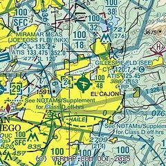
|
CAUTION: Diagram may not be current
 Download PDF
of official airport diagram from the FAA
| Airport distance calculator |
|---|
|
|
| Sunrise and sunset |
|---|
|
Times for 08-Mar-2025
| | Local
(UTC-8) | | Zulu
(UTC) |
|---|
| Morning civil twilight | | 05:43 | | 13:43 |
| Sunrise | | 06:08 | | 14:08 |
| Sunset | | 17:49 | | 01:49 |
| Evening civil twilight | | 18:14 | | 02:14 |
|
| Current date and time |
|---|
| Zulu (UTC) | 09-Mar-2025 01:04:39 |
|---|
| Local (UTC-8) | 08-Mar-2025 17:04:39 |
|---|
|
| METAR |
|---|
| KSEE | 090047Z 27008KT 10SM SKC 17/04 A3023
|
KMYF
8nm W | 090053Z 29007KT 10SM CLR 17/06 A3023 RMK AO2 SLP237 T01670056
|
KNKX
8nm W | 090055Z AUTO 27006KT 10SM CLR 16/07 A3023 RMK AO2 SLP234 T01560067 $
|
KSAN
12nm SW | 090051Z 31005KT 10SM CLR 16/10 A3025 RMK AO2 SLP243 T01610100 $
|
KRNM
13nm N | 090053Z 25010G16KT 10SM CLR 16/04 A3022 RMK AO2 SLP232 T01610039
|
KNZY
14nm SW | 090052Z 32009KT 10SM CLR 16/08 A3023 RMK AO2 SLP236 T01560083 $
|
KSDM
15nm S | 090053Z 29005KT 10SM CLR 16/07 A3023 RMK AO2 SLP236 T01560072 $
|
KNRS
17nm SW | 090053Z AUTO 29006KT 10SM CLR A3025 RMK AO2 SLP244 $
|
MMTJ
18nm S | 090041Z 26008KT 10SM SKC 16/04 A3026
|
|
| TAF |
|---|
KNKX
8nm W | 0821/0921 31009KT 9999 SKC QNH3023INS FM090300 33005KT 9999 SKC QNH3026INS BECMG 0906/0908 04004KT QNH3020INS FM091900 27006KT 9999 SKC QNH3018INS T19/0822Z T05/0913Z
|
KSAN
12nm SW | 082031Z 0821/0924 29010KT P6SM SKC FM090200 30005KT P6SM FEW250 FM092000 28008KT P6SM FEW250
|
KNZY
14nm SW | 0823/0923 29006KT 9999 SKC QNH3000INS FM090600 04006KT 9999 SKC QNH3000INS FM091700 34006KT 9999 SKC QNH3000INS AUTOMATED SENSOR METWATCH 0906 TIL 1015 TX14/0920Z TN11/0912Z FS30200
|
MMTJ
18nm S | 081717Z 0818/0918 30005KT P6SM SKC TX15/0820Z TN06/0912Z BECMG 0821/0822 30010KT FM090600 34005KT P6SM SKC BECMG 0916/0917 06005KT
|
|
| NOTAMs |
|---|
NOTAMs are issued by the DoD/FAA and will open in a separate window not controlled by AirNav.
|
|


