FAA INFORMATION EFFECTIVE 17 APRIL 2025
Location
| FAA Identifier: | X04 |
| Lat/Long: | 28-42-26.9079N 081-34-55.0722W
28-42.448465N 081-34.917870W
28.7074744,-81.5819645
(estimated) |
| Elevation: | 150 ft. / 46 m (estimated) |
| Variation: | 06W (2015) |
| From city: | 4 miles NW of APOPKA, FL |
| Time zone: | UTC -4 (UTC -5 during Standard Time) |
| Zip code: | 32798 |
Airport Operations
| Airport use: | Open to the public |
| Control tower: | no |
| ARTCC: | JACKSONVILLE CENTER |
| FSS: | SAINT PETERSBURG FLIGHT SERVICE STATION |
| NOTAMs facility: | PIE (NOTAM-D service available) |
| Attendance: | 0800-1800 |
| Wind indicator: | lighted |
| Segmented circle: | yes |
| Lights: | PAPI 15 & 33 ON CONT DURG DALGT. AFTER SS, ACTVT PAPI RWY 15 & 33; LIRL RWY 15/33 - CTAF. |
| Beacon: | white-green (lighted land airport)
Operates sunset to sunrise. |
Airport Communications
| CTAF/UNICOM: | 123.05 |
| ORLANDO APPROACH: | 135.3 |
| ORLANDO DEPARTURE: | 135.3 |
| GOOFY STAR: | 124.8 128.375 |
| WX ASOS at LEE (14 nm NW): | PHONE 352-787-1565 |
| WX ASOS at ORL (16 nm SE): | 127.25 (407-658-6753) |
| WX ASOS at SFB (19 nm E): | 125.975 (407-321-9384) |
Nearby radio navigation aids
| VOR radial/distance | | VOR name | | Freq | | Var |
|---|
| ORLr307/16.3 | | ORLANDO VORTAC | | 112.20 | | 00E |
Airport Services
| Fuel available: | 100LL JET-A |
| Parking: | hangars and tiedowns |
| Airframe service: | MAJOR |
| Powerplant service: | MAJOR |
Runway Information
Runway 15/33
| Dimensions: | 3987 x 60 ft. / 1215 x 18 m |
| Surface: | asphalt, in fair condition |
| Runway edge lights: | low intensity |
| RUNWAY 15 | | RUNWAY 33 |
| Latitude: | 28-42.728160N | | 28-42.168770N |
| Longitude: | 081-35.114220W | | 081-34.721520W |
| Elevation: | 142.2 ft. | | 125.2 ft. |
| Traffic pattern: | right | | left |
| Displaced threshold: | 943 ft. | | no |
| Declared distances: | TORA:3987 TODA:3987 ASDA:3987 LDA:3044 | | TODA:3987 ASDA:3987 LDA:3987 |
| Markings: | basic, in fair condition | | basic, in fair condition |
| Visual slope indicator: | 2-light PAPI on left (3.50 degrees glide path) | | 2-light PAPI on left (3.00 degrees glide path) |
| Touchdown point: | yes, no lights | | yes, no lights |
| Obstructions: | 10 ft. berm, 200 ft. from runway, 125 ft. left of centerline, 1:1 slope to clear
RWY 15 HAS 10 FT BERM 200 FT FM RWY END 125 FT LEFT. | | 57 ft. trees, 2170 ft. from runway, 150 ft. left of centerline, 34:1 slope to clear |
Airport Ownership and Management from official FAA records
| Ownership: | Privately-owned |
| Owner: | ORLANDO APOPKA ARPT CONDO ASSOC.
882 JACKSON AVE., REGISTERED AGENT
WINTER PARK, FL 32789
Phone 407-647-2622 |
| Manager: | BOB JACKSON
1321 APOPKA AIRPORT RD HANGAR 37
APOPKA, FL 32712
Phone 407-308-5904 |
Additional Remarks
| - | STEEP DROPOFF 63 FT FM SE END & APRXLY 60 FT OFF WEST & EAST EDGE. |
| - | CALM WIND RWY 33. |
| - | TOUCH AND GO OPS PROHIBITED IF THREE OR MORE ACFT IN THE TFC PAT. |
| - | RY 15/33 RR PENETRATES 7:1 TRANS SFC EAST SIDE. |
| - | RY 15/33 CLSD TO TOUCH AND GO LNDGS BY TRANSIENT HELICOPTERS. |
| - | FOR CD CTC JACKSONVILLE ARTCC AT 904-845-1592. |
| - | AUTOMATED UNICOM WX AND LGT - CTAF. |
| - | NO OVNGT PRKG ON APRON BTN TWY A1 AND A2. NO OVNGT RAMP PRKG AVBL - TEXT 951-818-8408 FOR PAID PVT PRKG OPTIONS. |
| - | PWRD PARAGLIDERS OPERATING W OF RWY 15/33. |
Instrument Procedures
NOTE: All procedures below are presented as PDF files. If you need a reader for these files, you should download the free Adobe Reader.NOT FOR NAVIGATION. Please procure official charts for flight.
FAA instrument procedures published for use from 17 April 2025 at 0901Z to 15 May 2025 at 0900z.
STARs - Standard Terminal Arrivals |
|---|
| GOOFY SEVEN | |
download (251KB) |
IAPs - Instrument Approach Procedures |
|---|
| RNAV (GPS)-A | |
download (214KB) |
| RNAV (GPS)-B | |
download (190KB) |
| NOTE: Special Take-Off Minimums/Departure Procedures apply | |
download (162KB) |
Other nearby airports with instrument procedures:
X23 - Umatilla Municipal Airport (14 nm N)
KLEE - Leesburg International Airport (14 nm NW)
KORL - Executive Airport (16 nm SE)
KSFB - Orlando Sanford International Airport (19 nm E)
KMCO - Orlando International Airport (22 nm SE)
|
|

Road maps at:
MapQuest
Bing
Google
| Aerial photo |
|---|
WARNING: Photo may not be current or correct
 Photo by Jim Hobart of MacBethPhoto.com
Photo taken 14-Jul-2011
looking northwest.
Photo by Jim Hobart of MacBethPhoto.com
Photo taken 14-Jul-2011
looking northwest.
Do you have a better or more recent aerial photo of Orlando Apopka Airport that you would like to share? If so, please send us your photo.
|
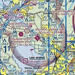
| Sectional chart |
|---|
|
| Airport distance calculator |
|---|
|
|
| Sunrise and sunset |
|---|
|
Times for 19-Apr-2025
| | Local
(UTC-4) | | Zulu
(UTC) |
|---|
| Morning civil twilight | | 06:33 | | 10:33 |
| Sunrise | | 06:58 | | 10:58 |
| Sunset | | 19:53 | | 23:53 |
| Evening civil twilight | | 20:18 | | 00:18 |
|
| Current date and time |
|---|
| Zulu (UTC) | 19-Apr-2025 08:12:13 |
|---|
| Local (UTC-4) | 19-Apr-2025 04:12:13 |
|---|
|
| METAR |
|---|
KLEE
14nm NW | 190753Z AUTO 08006KT 10SM CLR 19/17 A3026 RMK AO2 SLP244 T01940167
|
KSFB
20nm E | 190753Z AUTO 09003KT 10SM CLR 17/16 A3024 RMK AO2 SLP239 T01670156
|
KMCO
22nm SE | 190753Z 08005KT 10SM CLR 18/16 A3024 RMK AO2 SLP239 T01830161
|
KISM
27nm S | 190756Z AUTO 06003KT 10SM CLR 19/17 A3025 RMK AO2 SLP242 T01940172 $
|
KDED
27nm NE | 190755Z AUTO 00000KT 10SM CLR 16/14 A3026 RMK AO2 T01580142
|
|
| TAF |
|---|
KLEE
14nm NW | 190520Z 1906/2006 10006KT P6SM SKC FM191400 11012G20KT P6SM FEW045 FM200000 10011KT P6SM FEW035
|
KSFB
20nm E | 190520Z 1906/2006 VRB04KT P6SM SKC FM191400 11014G20KT P6SM FEW040 FM191800 11017G25KT P6SM FEW050 FM200000 11010KT P6SM FEW030
|
|
| NOTAMs |
|---|
NOTAMs are issued by the DoD/FAA and will open in a separate window not controlled by AirNav.
|
|


