FAA INFORMATION EFFECTIVE 23 JANUARY 2025
Location
| FAA Identifier: | Y95 |
| Lat/Long: | 45-04-59.5902N 083-56-18.5802W
45-04.993170N 083-56.309670W
45.0832195,-83.9384945
(estimated) |
| Elevation: | 852 ft. / 260 m (estimated) |
| Variation: | 06W (1985) |
| From city: | 2 miles NW of HILLMAN, MI |
| Time zone: | UTC -5 (UTC -4 during Daylight Saving Time) |
| Zip code: | 49746 |
Airport Operations
| Airport use: | Open to the public |
| Activation date: | 04/1940 |
| Control tower: | no |
| ARTCC: | MINNEAPOLIS CENTER |
| FSS: | LANSING FLIGHT SERVICE STATION |
| NOTAMs facility: | LAN (NOTAM-D service available) |
| Attendance: | UNATNDD
SNOW REMOVAL SCND PRIORITY - CALL AMGR TO CFM ARPT CONDS. |
| Wind indicator: | lighted |
| Segmented circle: | yes |
| Lights: | ACTVT MIRL RWY 04/22 - CTAF. |
Airport Communications
| CTAF: | 122.9 |
| WX ASOS at APN (16 nm E): | 120.675 (989-356-1576) |
Nearby radio navigation aids
| VOR radial/distance | | VOR name | | Freq | | Var |
|---|
| APNr277/16.2 | | ALPENA VORTAC | | 116.50 | | 07W |
Airport Services
| Parking: | tiedowns |
| Powerplant service: | NONE |
| Bottled oxygen: | NONE |
| Bulk oxygen: | NONE |
Runway Information
Runway 4/22
| Dimensions: | 3400 x 60 ft. / 1036 x 18 m |
| Surface: | asphalt, in fair condition |
| Runway edge lights: | medium intensity |
| RUNWAY 4 | | RUNWAY 22 |
| Latitude: | 45-04.747167N | | 45-05.232500N |
| Longitude: | 083-56.384167W | | 083-55.990667W |
| Elevation: | 844.0 ft. | | 847.0 ft. |
| Traffic pattern: | left | | left |
| Runway heading: | 036 magnetic, 030 true | | 216 magnetic, 210 true |
| Displaced threshold: | no | | 760 ft. |
| Markings: | basic, in fair condition | | basic, in fair condition |
| Obstructions: | 57 ft. trees, 854 ft. from runway, 60 ft. right of centerline, 11:1 slope to clear | | 81 ft. trees, 418 ft. from runway, 95 ft. right of centerline, 5:1 slope to clear
APCH RATIO 17:1 TO DTHR. |
Runway 18/36
| Dimensions: | 2900 x 100 ft. / 884 x 30 m |
| Surface: | turf, in poor condition
ROUGH & MDTLY ROLLING TRRN; OCNL TALL GRASS - CALL TO VFY FICON. |
| Runway edge markings: | 3 FT YELLOW CONES. |
| RUNWAY 18 | | RUNWAY 36 |
| Latitude: | 45-05.235833N | | 45-04.758333N |
| Longitude: | 083-56.454833W | | 083-56.451167W |
| Elevation: | 852.0 ft. | | 844.0 ft. |
| Traffic pattern: | left | | left |
| Runway heading: | 186 magnetic, 180 true | | 006 magnetic, 360 true |
| Displaced threshold: | 1400 ft. | | no |
| Obstructions: | 75 ft. trees, 304 ft. from runway, 125 ft. left and right of centerline, 4:1 slope to clear
APCH RATIO 20:1 TO DTHR. | | 58 ft. tree, 1170 ft. from runway, 65 ft. right of centerline, 16:1 slope to clear |
Airport Ownership and Management from official FAA records
| Ownership: | Publicly-owned |
| Owner: | VILLAGE OF HILLMAN
PO BOX 96
HILLMAN, MI 49746-0096
Phone 989-742-4751 |
| Manager: | MARK MELLINGEN
1994 HAHN TRL
HILLMAN, MI 49746-9616
Phone 989-306-4659
RES 989-742-2893. |
Additional Remarks
| - | FOR CD CTC MINNEAPOLIS ARTCC AT 651-463-5588. |
| - | DEER, LRG BIRDS, & WILDLIFE ON & INVOF ARPT. |
Instrument Procedures
There are no published instrument procedures at Y95.
Some nearby airports with instrument procedures:
KAPN - Alpena County Regional Airport (16 nm E)
KPZQ - Presque Isle County Airport (20 nm N)
KGLR - Gaylord Regional Airport (33 nm W)
KGOV - Grayling Army Airfield (41 nm SW)
KBFA - Boyne Mountain Airport (42 nm W)
|
|

Road maps at:
MapQuest
Bing
Google
| Aerial photo |
|---|
WARNING: Photo may not be current or correct
 Photo by Scott Sutherland
Photo taken 27-Apr-2012
looking north from 2700'.
Photo by Scott Sutherland
Photo taken 27-Apr-2012
looking north from 2700'.
Do you have a better or more recent aerial photo of Hillman Airport that you would like to share? If so, please send us your photo.
|
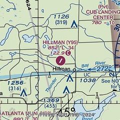
| Sectional chart |
|---|
|
| Airport distance calculator |
|---|
|
|
| Sunrise and sunset |
|---|
|
Times for 06-Feb-2025
| | Local
(UTC-5) | | Zulu
(UTC) |
|---|
| Morning civil twilight | | 07:20 | | 12:20 |
| Sunrise | | 07:51 | | 12:51 |
| Sunset | | 17:49 | | 22:49 |
| Evening civil twilight | | 18:20 | | 23:20 |
|
| Current date and time |
|---|
| Zulu (UTC) | 06-Feb-2025 19:53:28 |
|---|
| Local (UTC-5) | 06-Feb-2025 14:53:28 |
|---|
|
| METAR |
|---|
KAPN
16nm E | 061854Z 23008G17KT 10SM OVC015 M02/M05 A2954 RMK AO2 SLP013 T10221050
|
KPZQ
20nm N | 061935Z AUTO 25012G20KT 10SM OVC016 M02/M05 A2951 RMK AO2 T10181050
|
|
| TAF |
|---|
KAPN
16nm E | 061741Z 0618/0718 24008KT P6SM VCSH BKN028 FM062100 25017G32KT 6SM BR VCSH BKN035 TEMPO 0700/0702 1SM -SHSN BLSN FM070200 28018G35KT P6SM VCSH OVC035 FM071200 28012G25KT P6SM SCT070
|
|
| NOTAMs |
|---|
NOTAMs are issued by the DoD/FAA and will open in a separate window not controlled by AirNav.
|
|


