FAA INFORMATION EFFECTIVE 17 APRIL 2025
Location
| FAA Identifier: | 17N |
| Lat/Long: | 39-42-19.7130N 075-01-58.8110W
39-42.328550N 075-01.980183W
39.7054758,-75.0330031
(estimated) |
| Elevation: | 162 ft. / 49 m (estimated) |
| Variation: | 10W (1980) |
| From city: | 1 mile S of CROSS KEYS, NJ |
| Time zone: | UTC -4 (UTC -5 during Standard Time) |
| Zip code: | 08094 |
Airport Operations
| Airport use: | Open to the public |
| Activation date: | 06/1954 |
| Control tower: | no |
| ARTCC: | NEW YORK CENTER |
| FSS: | MILLVILLE FLIGHT SERVICE STATION |
| NOTAMs facility: | MIV (NOTAM-D service available) |
| Attendance: | 0800-1700 |
| Pattern altitude: | 1000 ft. MSL |
| Wind indicator: | lighted |
| Segmented circle: | no |
| Lights: | SS-SR |
| Beacon: | white-green (lighted land airport)
Operates sunset to sunrise. |
Airport Communications
| CTAF/UNICOM: | 122.8 |
| PHILADELPHIA APPROACH: | 127.35 133.875 |
| PHILADELPHIA DEPARTURE: | 127.35 133.875 |
| WX AWOS-AV at N81 (13 nm E): | 122.7 |
| WX ASOS at PHL (14 nm NW): | 133.4 (215-492-9617) |
| WX ASOS at VAY (17 nm NE): | 119.325 (609-267-1176) |
Nearby radio navigation aids
| VOR radial/distance | | VOR name | | Freq | | Var |
|---|
| VCNr353/10.5 | | CEDAR LAKE VOR/DME | | 115.20 | | 10W |
| OODr082/13.1 | | WOODSTOWN VORTAC | | 112.80 | | 10W |
| ACYr315/25.9 | | ATLANTIC CITY VORTAC | | 117.15 | | 10W |
| DQOr096/26.6 | | DUPONT VORTAC | | 114.00 | | 10W |
| GXUr240/27.1 | | MC GUIRE VORTAC | | 110.60 | | 12W |
| CYNr266/28.5 | | COYLE VORTAC | | 113.40 | | 10W |
| MXEr122/32.0 | | MODENA VORTAC | | 113.20 | | 09W |
| ARDr200/33.4 | | YARDLEY VOR/DME | | 108.20 | | 10W |
| ENOr047/36.2 | | SMYRNA VORTAC | | 111.40 | | 09W |
| SIEr353/38.2 | | SEA ISLE VORTAC | | 114.80 | | 09W |
| RBVr230/38.7 | | ROBBINSVILLE VORTAC | | 113.80 | | 10W |
| PTWr151/39.4 | | POTTSTOWN VORTAC | | 116.50 | | 09W |
| NDB name | | Hdg/Dist | | Freq | | Var | | ID |
|---|
| RAINBOW | | 026/17.9 | | 363 | | 11W | | RNB | .-. -. -... |
| LAKEHURST | | 249/38.0 | | 396 | | 11W | | NEL | -. . .-.. |
Airport Services
| Fuel available: | 100LL JET-A |
| Parking: | tiedowns |
| Airframe service: | NONE |
| Powerplant service: | NONE |
| Bottled oxygen: | NONE |
| Bulk oxygen: | NONE |
Runway Information
Runway 9/27
| Dimensions: | 3500 x 50 ft. / 1067 x 15 m |
| Surface: | asphalt, in good condition |
| Weight bearing capacity: | |
| Runway edge lights: | non-standard
LIRL LGT SPACING NSTD. |
| RUNWAY 9 | | RUNWAY 27 |
| Latitude: | 39-42.249150N | | 39-42.408350N |
| Longitude: | 075-02.338567W | | 075-01.621217W |
| Elevation: | 137.0 ft. | | 161.0 ft. |
| Traffic pattern: | right | | left |
| Runway heading: | 084 magnetic, 074 true | | 264 magnetic, 254 true |
| Displaced threshold: | no | | 200 ft.
DSPLCD THLD MARKED WITH LGTS. |
| Markings: | nonprecision, in fair condition | | basic, in fair condition |
| Runway end identifier lights: | no | | no |
| Touchdown point: | yes, no lights | | yes, no lights |
| Obstructions: | 90 ft. trees, 900 ft. from runway, 250 ft. left of centerline, 7:1 slope to clear
+20 FT TREES 50 FT RT & LFT OF EXTD CTLN 0-200 FT FM APP END. +60 FT TREES 200 FT RT & LFT OF EXTD CTLN AT APP END. | | 73 ft. tree, 570 ft. from runway, 135 ft. right of centerline, 5:1 slope to clear
ROAD, FENCE, BLDGS, & TREES NEAR APCH END. |
Airport Ownership and Management from official FAA records
| Ownership: | Privately-owned |
| Owner: | CROSS KEYS AIRPORT INC
1531 N. TUCKAHOE ROAD
WILLIAMSTOWN, NJ 08094
Phone 856-629-3033 |
| Manager: | HARRY STRAHLENDORF
1531 N. TUCKAHOE ROAD
WILLIAMSTOWN, NJ 08094
Phone 856-629-3033 |
Additional Remarks
| - | DUE TO PARACHUTE DROP ZONE ON N SIDE OF ARPT, ALL TFC TO REMAIN S OF RWY 09/27. |
| - | DEER & BIRDS ON & INVOF ARPT. |
| - | ARPT UNATTND THANKSGIVING, CHRISTMAS, NEW YEAR'S DAY AND EASTER. |
| - | FOR CD CTC PHILADELPHIA APCH AT 800-354-9884. |
Instrument Procedures
NOTE: All procedures below are presented as PDF files. If you need a reader for these files, you should download the free Adobe Reader.NOT FOR NAVIGATION. Please procure official charts for flight.
FAA instrument procedures published for use from 17 April 2025 at 0901Z to 15 May 2025 at 0900z.
IAPs - Instrument Approach Procedures |
|---|
| RNAV (GPS) RWY 09 | |
download (163KB) |
| NOTE: Special Take-Off Minimums/Departure Procedures apply | |
download (150KB) |
Other nearby airports with instrument procedures:
19N - Pine Valley Airport (6 nm NE)
N81 - Hammonton Municipal Airport (13 nm E)
KPHL - Philadelphia International Airport (14 nm NW)
KVAY - South Jersey Regional Airport (17 nm NE)
N14 - Flying W Airport (17 nm NE)
|
|

Road maps at:
MapQuest
Bing
Google
| Aerial photo |
|---|
WARNING: Photo may not be current or correct
 Photo courtesy of AirNav, LLC
Photo taken 21-Jul-2010
Photo courtesy of AirNav, LLC
Photo taken 21-Jul-2010
Do you have a better or more recent aerial photo of Cross Keys Airport that you would like to share? If so, please send us your photo.
|
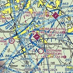
| Sectional chart |
|---|
|
| Airport distance calculator |
|---|
|
|
| Sunrise and sunset |
|---|
|
Times for 22-Apr-2025
| | Local
(UTC-4) | | Zulu
(UTC) |
|---|
| Morning civil twilight | | 05:45 | | 09:45 |
| Sunrise | | 06:14 | | 10:14 |
| Sunset | | 19:44 | | 23:44 |
| Evening civil twilight | | 20:12 | | 00:12 |
|
| Current date and time |
|---|
| Zulu (UTC) | 23-Apr-2025 02:50:43 |
|---|
| Local (UTC-4) | 22-Apr-2025 22:50:43 |
|---|
|
| METAR |
|---|
KPHL
13nm NW | 230154Z 28005KT 10SM FEW200 BKN240 BKN300 19/06 A3005 RMK AO2 SLP173 T01940056 $
|
KVAY
16nm NE | ASOS 119.325 609-267-1176
230154Z AUTO 00000KT 10SM CLR 16/08 A3004 RMK AO2 SLP172 T01610078 $
|
KMIV
20nm S | 230154Z AUTO 00000KT 10SM CLR 17/07 A3005 RMK AO2 SLP174 T01670067
|
KPNE
23nm N | 230154Z 27005KT 10SM CLR 18/04 A3006 RMK AO2 SLP177 T01830044
|
KACY
25nm SE | 230154Z AUTO 30006KT 10SM CLR 19/06 A3004 RMK AO2 SLP170 T01890061
|
KILG
26nm W | 230151Z AUTO 31007KT 10SM CLR 16/06 A3006 RMK AO2 SLP177 T01560061
|
|
| TAF |
|---|
KPHL
13nm NW | 230202Z 2302/2406 29007KT P6SM BKN250 FM230500 34005KT P6SM BKN250 FM231000 01007KT P6SM SCT250 FM231800 25007KT P6SM FEW250 FM232000 22005KT P6SM SKC
|
|
| NOTAMs |
|---|
NOTAMs are issued by the DoD/FAA and will open in a separate window not controlled by AirNav.
|
|


