FAA INFORMATION EFFECTIVE 17 APRIL 2025
Location
| FAA Identifier: | ESC |
| Lat/Long: | 45-43-21.6270N 087-05-37.3770W
45-43.360450N 087-05.622950W
45.7226742,-87.0937158
(estimated) |
| Elevation: | 609.1 ft. / 185.7 m (surveyed) |
| Variation: | 05W (2025) |
| From city: | 2 miles SW of ESCANABA, MI |
| Time zone: | UTC -4 (UTC -5 during Standard Time) |
| Zip code: | 49829 |
Airport Operations
| Airport use: | Open to the public |
| Activation date: | 04/1940 |
| Control tower: | no |
| ARTCC: | MINNEAPOLIS CENTER |
| FSS: | GREEN BAY FLIGHT SERVICE STATION |
| NOTAMs facility: | ESC (NOTAM-D service available) |
| Attendance: | 0600-2130
FOR SVC CALL ARPT OPS 906-420-1591. |
| Wind indicator: | lighted |
| Segmented circle: | yes |
| Lights: | ACTVT MALSR RWY 10; REIL RWY 01 & 28; PAPI RWY 28, 01, & 19; HIRL RWY 10/28; MIRL RWY 01/19 - CTAF. |
| Beacon: | white-green (lighted land airport)
Operates sunset to sunrise. |
| Landing fee: | no, COML/CHTR ACFT SUBJ LDG FEE - CALL FOR RATES. |
| Fire and rescue: | ARFF index A |
Airport Communications
| CTAF/UNICOM: | 122.8 |
| WX AWOS-3PT: | 121.425 (906-786-9001) |
- APCH/DEP SVC PRVDD BY MINNEAPOLIS ARTCC ON FREQ 127.65 (ESCANABA RCAG).
Nearby radio navigation aids
| VOR radial/distance | | VOR name | | Freq | | Var |
|---|
| ESC at field | | ESCANABA VOR/DME | | 113.55 | | 00E |
| NDB name | | Hdg/Dist | | Freq | | Var | | ID |
|---|
| PIKLE | | 095/5.5 | | 344 | | 05W | | ES | . ... |
Airport Services
| Fuel available: | 100LL JET-A
100LL:100LL AVBL H24 SELF SVC. |
| Parking: | hangars and tiedowns |
| Airframe service: | NONE |
| Powerplant service: | NONE |
| Bottled oxygen: | NONE |
| Bulk oxygen: | NONE |
Runway Information
Runway 10/28
| Dimensions: | 6498 x 150 ft. / 1981 x 46 m |
| Surface: | asphalt/porous friction courses, in good condition |
| Weight bearing capacity: | | Single wheel: | 111.0 | | Double wheel: | 170.0 | | Double tandem: | 251.0 | | Dual double tandem: | 699.0 |
|
| Runway edge lights: | high intensity |
| RUNWAY 10 | | RUNWAY 28 |
| Latitude: | 45-43.249327N | | 45-43.232705N |
| Longitude: | 087-06.716133W | | 087-05.189998W |
| Elevation: | 609.1 ft. | | 593.1 ft. |
| Traffic pattern: | left | | left |
| Runway heading: | 096 magnetic, 091 true | | 276 magnetic, 271 true |
| Declared distances: | TORA:6498 TODA:6498 ASDA:6498 LDA:6498 | | TORA:6498 TODA:6498 ASDA:6498 LDA:6498 |
| Markings: | precision, in good condition | | precision, in good condition |
| Visual slope indicator: | | | 4-light PAPI on right (3.00 degrees glide path) |
| Approach lights: | MALSR: 1,400 foot medium intensity approach lighting system with runway alignment indicator lights | | |
| Runway end identifier lights: | no | | yes |
| Touchdown point: | yes, no lights | | yes, no lights |
| Instrument approach: | ILS/DME | | |
Runway 1/19
| Dimensions: | 5016 x 100 ft. / 1529 x 30 m |
| Surface: | asphalt/porous friction courses, in good condition |
| Weight bearing capacity: | | Single wheel: | 71.0 | | Double wheel: | 103.0 | | Double tandem: | 169.0 |
|
| Runway edge lights: | medium intensity |
| RUNWAY 1 | | RUNWAY 19 |
| Latitude: | 45-43.102510N | | 45-43.927700N |
| Longitude: | 087-05.204440W | | 087-05.186085W |
| Elevation: | 592.2 ft. | | 607.0 ft. |
| Traffic pattern: | left | | left |
| Runway heading: | 006 magnetic, 001 true | | 186 magnetic, 181 true |
| Declared distances: | TORA:5015 TODA:5015 ASDA:5015 LDA:5015 | | TORA:5015 TODA:5015 ASDA:5015 LDA:5015 |
| Markings: | nonprecision, in good condition | | nonprecision, in good condition |
| Visual slope indicator: | 4-light PAPI on left (3.00 degrees glide path) | | 4-light PAPI on left (3.00 degrees glide path) |
| Runway end identifier lights: | yes | | |
| Touchdown point: | yes, no lights | | yes, no lights |
| Obstructions: | 51 ft. tree, 1871 ft. from runway, 61 ft. right of centerline, 31:1 slope to clear | | none |
Airport Ownership and Management from official FAA records
| Ownership: | Publicly-owned |
| Owner: | DELTA COUNTY
310 LUDINGTON ST
ESCANABA, MI 49829-4057
Phone 906-789-5100 |
| Manager: | ROBERT RANSTADLER
DELTA COUNTY AIRPORT, 3300 AIRPORT RD
ESCANABA, MI 49829-1057
Phone 906-217-7593 |
Additional Remarks
| A39-01/19 | PCR VALUE: 280/F/C/X/U |
| A39-10/28 | PCR VALUE: 460/F/C/X/U |
| - | FLD CONDS UNMON 2130-0600. |
| - | FOR CD IF UNA TO CTC ON FSS FREQ, CTC MINNEAPOLIS ARTCC AT 651-463-5588. |
| - | BIRDS ON & INVOF ARPT. |
Instrument Procedures
NOTE: All procedures below are presented as PDF files. If you need a reader for these files, you should download the free Adobe Reader.NOT FOR NAVIGATION. Please procure official charts for flight.
FAA instrument procedures published for use from 17 April 2025 at 0901Z to 15 May 2025 at 0900z.
IAPs - Instrument Approach Procedures |
|---|
| ILS OR LOC RWY 10 | |
download (279KB) |
| RNAV (GPS) RWY 01 | |
download (211KB) |
| RNAV (GPS) RWY 10 | |
download (249KB) |
| RNAV (GPS) RWY 19 | |
download (193KB) |
| RNAV (GPS) RWY 28 | |
download (256KB) |
| LOC BC RWY 28 | |
download (271KB) |
| VOR RWY 01 | |
download (192KB) |
| NOTE: Special Alternate Minimums apply | |
download (139KB) |
| NOTE: Special Take-Off Minimums/Departure Procedures apply | |
download (349KB) |
Other nearby airports with instrument procedures:
2P2 - Washington Island Airport (21 nm S)
3D2 - Ephraim/Gibraltar Airport (35 nm S)
KSAW - Marquette/Sawyer Regional Airport (40 nm N)
KISQ - Schoolcraft County Airport (41 nm E)
KMNM - Menominee Regional Airport (42 nm SW)
|
|

Road maps at:
MapQuest
Bing
Google
| Aerial photo |
|---|
WARNING: Photo may not be current or correct
 Photo by Dan Weber
Photo taken 09-Dec-2011
looking north.
Photo by Dan Weber
Photo taken 09-Dec-2011
looking north.
Do you have a better or more recent aerial photo of Delta County Airport that you would like to share? If so, please send us your photo.
|
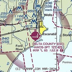
| Sectional chart |
|---|
|
| Airport distance calculator |
|---|
|
|
| Sunrise and sunset |
|---|
|
Times for 30-Apr-2025
| | Local
(UTC-4) | | Zulu
(UTC) |
|---|
| Morning civil twilight | | 06:06 | | 10:06 |
| Sunrise | | 06:38 | | 10:38 |
| Sunset | | 20:53 | | 00:53 |
| Evening civil twilight | | 21:26 | | 01:26 |
|
| Current date and time |
|---|
| Zulu (UTC) | 30-Apr-2025 10:38:10 |
|---|
| Local (UTC-4) | 30-Apr-2025 06:38:10 |
|---|
|
| METAR |
|---|
KESC
4nm NE | 300956Z AUTO 22004KT 10SM CLR M04/M05 A3023 RMK AO2 SLP246 T10391050 FZRANO
|
|
| TAF |
|---|
KSAW
40nm N | 300520Z 3006/0106 03007KT P6SM BKN026 FM301200 20005KT P6SM FEW080 FM301400 19007G18KT P6SM FEW050 FM302000 18010G19KT P6SM SCT130
|
|
| NOTAMs |
|---|
NOTAMs are issued by the DoD/FAA and will open in a separate window not controlled by AirNav.
|
|


