FAA INFORMATION EFFECTIVE 20 FEBRUARY 2025
Location
| FAA Identifier: | 3D2 |
| Lat/Long: | 45-08-08.5469N 087-11-17.2611W
45-08.142448N 087-11.287685W
45.1357075,-87.1881281
(estimated) |
| Elevation: | 763.2 ft. / 232.6 m (surveyed) |
| Variation: | 04W (2000) |
| From city: | 1 mile SW of EPHRAIM, WI |
| Time zone: | UTC -6 (UTC -5 during Daylight Saving Time) |
| Zip code: | 54212 |
Airport Operations
| Airport use: | Open to the public |
| Activation date: | 10/1947 |
| Control tower: | no |
| ARTCC: | MINNEAPOLIS CENTER |
| FSS: | GREEN BAY FLIGHT SERVICE STATION |
| NOTAMs facility: | GRB (NOTAM-D service available) |
| Attendance: | JUN-OCT FRI 1500-1800, JUN-OCT SAT-SUN 1000-1700 |
| Wind indicator: | lighted |
| Segmented circle: | yes |
| Lights: | MIRL RWY 14/32 PRESET LOW SS-SR; INCR INTST AND ACTVT PAPI RWY 14 & 32 - CTAF. |
| Beacon: | white-green (lighted land airport)
Operates sunset to sunrise. |
Airport Communications
| CTAF/UNICOM: | 123.0 |
| WX AWOS-3PT: | 124.175 (920-854-5559) |
| GREEN BAY APPROACH: | 120.3 |
| GREEN BAY DEPARTURE: | 120.3 |
| WX AWOS-3PT at 2P2 (19 nm NE): | 118.525 (920 847 3024) |
| WX AWOS-3PT at MNM (19 nm W): | 121.45 (906-863-8801) |
- APCH/DEP SVC PRVDD BY MINNEAPOLIS ARTCC ON FREQ 127.65 (ESCANABA RCAG) WHEN GREEN BAY APCH CTL CLSD.
Nearby radio navigation aids
| VOR radial/distance | | VOR name | | Freq | | Var |
|---|
| ESCr187/35.5 | | ESCANABA VOR/DME | | 113.55 | | 00E |
Airport Services
| Fuel available: | 100LL
100LL:24 HR SELF SVC FUEL AVBL WITH CREDIT CARD. |
| Parking: | tiedowns |
| Airframe service: | NONE |
| Powerplant service: | NONE |
| Bottled oxygen: | NONE |
| Bulk oxygen: | NONE |
Runway Information
Runway 14/32
| Dimensions: | 2697 x 60 ft. / 822 x 18 m |
| Surface: | asphalt, in good condition |
| Weight bearing capacity: | |
| Runway edge lights: | medium intensity |
| RUNWAY 14 | | RUNWAY 32 |
| Latitude: | 45-08.281920N | | 45-07.961313N |
| Longitude: | 087-11.369002W | | 087-10.935332W |
| Elevation: | 763.2 ft. | | 750.9 ft. |
| Traffic pattern: | left | | left |
| Runway heading: | 140 magnetic, 136 true | | 320 magnetic, 316 true |
| Markings: | nonprecision, in fair condition | | nonprecision, in fair condition |
| Visual slope indicator: | 2-light PAPI on left (3.50 degrees glide path) | | 2-light PAPI on left (3.00 degrees glide path) |
| Runway end identifier lights: | no | | no |
| Touchdown point: | yes, no lights | | yes, no lights |
Runway 1/19
| Dimensions: | 2324 x 100 ft. / 708 x 30 m |
| Surface: | turf, in fair condition
SLOPES MDTELY DOWN TO SOUTH--CANNOT SEE ONE END FM THE OTHER. |
| Runway edge markings: | MKD WITH YELLOW CONES. |
| RUNWAY 1 | | RUNWAY 19 |
| Latitude: | 45-07.977500N | | 45-08.356167N |
| Longitude: | 087-11.482833W | | 087-11.408000W |
| Elevation: | 754.9 ft. | | 762.9 ft. |
| Traffic pattern: | left | | left |
| Runway heading: | 012 magnetic, 008 true | | 192 magnetic, 188 true |
| Markings: | none | | none |
| Touchdown point: | yes, no lights | | yes, no lights |
Airport Ownership and Management from official FAA records
| Ownership: | Publicly-owned |
| Owner: | VILLAGE OF EPHRAIM
PO BOX 850
FISH CREEK, WI 54212
Phone 920-868-1714
& TOWN OF GIBRALTAR. |
| Manager: | TRAVIS THYSSEN
P O BOX 850
FISH CREEK, WI 54212
Phone 920-868-1714
ARPT OFC PHONE NR 920-854-3312, AVBL JUN-OCT, FRI-SUN. |
Additional Remarks
| - | DEER NR MOVEMENT AREAS. |
| - | FOR CD CTC GREEN BAY APCH AT 920-431-5741, WHEN GREEN BAY APCH CLSD, FOR CD CTC MINNEAPOLIS ARTCC AT 651-463-5588. |
Instrument Procedures
NOTE: All procedures below are presented as PDF files. If you need a reader for these files, you should download the free Adobe Reader.NOT FOR NAVIGATION. Please procure official charts for flight.
FAA instrument procedures published for use from 20 February 2025 at 0901Z to 20 March 2025 at 0900Z.
IAPs - Instrument Approach Procedures |
|---|
| RNAV (GPS) RWY 14 | |
download (177KB) |
| RNAV (GPS) RWY 32 | |
download (202KB) |
| NOTE: Special Alternate Minimums apply | |
download (162KB) |
| NOTE: Special Take-Off Minimums/Departure Procedures apply | |
download (479KB) |
Other nearby airports with instrument procedures:
2P2 - Washington Island Airport (19 nm NE)
KMNM - Menominee Regional Airport (19 nm W)
KSUE - Door County Cherryland Airport (20 nm SW)
KOCQ - Oconto/J Douglas Bake Municipal Airport (34 nm SW)
KESC - Delta County Airport (35 nm N)
|
|

Road maps at:
MapQuest
Bing
Google
| Aerial photo |
|---|
WARNING: Photo may not be current or correct
 Photo by Jeff Koon
Photo taken 22-Aug-2010
looking Northeast.
Photo by Jeff Koon
Photo taken 22-Aug-2010
looking Northeast.
Do you have a better or more recent aerial photo of Ephraim/Gibraltar Airport that you would like to share? If so, please send us your photo.
|
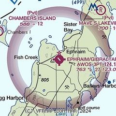
| Sectional chart |
|---|
|
| Airport distance calculator |
|---|
|
|
| Sunrise and sunset |
|---|
|
Times for 06-Mar-2025
| | Local
(UTC-6) | | Zulu
(UTC) |
|---|
| Morning civil twilight | | 05:49 | | 11:49 |
| Sunrise | | 06:19 | | 12:19 |
| Sunset | | 17:41 | | 23:41 |
| Evening civil twilight | | 18:11 | | 00:11 |
|
| Current date and time |
|---|
| Zulu (UTC) | 06-Mar-2025 06:54:19 |
|---|
| Local (UTC-6) | 06-Mar-2025 00:54:19 |
|---|
|
| METAR |
|---|
| K3D2 | 060635Z AUTO 32014G22KT 10SM OVC026 M06/M11 A2949 RMK AO2 T10641106
|
KMNM
18nm W | 060557Z AUTO 33010G18KT 290V360 10SM OVC028 M06/M09 A2952 RMK AO2 PK WND 35026/0522 SLP002 60000 T10611094 11050 21061 53028 FZRANO $
|
K2P2
19nm NE | 060635Z AUTO 32014G22KT 280V350 10SM OVC023 M06/M08 A2947 RMK AO2 T10561078
|
KSUE
20nm SW | 060557Z AUTO 33020G25KT 10SM OVC029 M06/M09 A2950 RMK AO2 PK WND 33030/0542 SNE32 SLP997 P0000 60000 T10561094 11050 21056 400501056 51027 FZRANO
|
|
| NOTAMs |
|---|
NOTAMs are issued by the DoD/FAA and will open in a separate window not controlled by AirNav.
|
|


