FAA INFORMATION EFFECTIVE 20 FEBRUARY 2025
Location
| FAA Identifier: | MNM |
| Lat/Long: | 45-07-36.0760N 087-38-18.7540W
45-07.601267N 087-38.312567W
45.1266878,-87.6385428
(estimated) |
| Elevation: | 624.6 ft. / 190.4 m (surveyed) |
| Variation: | 03W (1990) |
| From city: | 1 mile NW of MENOMINEE, MI |
| Time zone: | UTC -6 (UTC -5 during Daylight Saving Time) |
| Zip code: | 49858 |
Airport Operations
| Airport use: | Open to the public |
| Activation date: | 06/1947 |
| Control tower: | no |
| ARTCC: | MINNEAPOLIS CENTER |
| FSS: | GREEN BAY FLIGHT SERVICE STATION |
| NOTAMs facility: | MNM (NOTAM-D service available) |
| Attendance: | MON-FRI 0800-1600
FOR ATTENDANT AFT HRS CALL AMGR, IF UNA CALL ASST MGR CELL 262-365-1991. |
| Wind indicator: | lighted |
| Segmented circle: | no |
| Lights: | ACTVT MALSR RWY 03; REIL RWY 21; PAPI RWY 21, 14, & 32; HIRL RWY 03/21; MIRL RWY 14/32 - CTAF. |
| Beacon: | white-green (lighted land airport)
Operates sunset to sunrise. |
Airport Communications
| CTAF/UNICOM: | 122.8 |
| WX AWOS-3PT: | 121.45 (906-863-8801) |
| GREEN BAY APPROACH: | 120.3 |
| GREEN BAY DEPARTURE: | 120.3 |
| WX AWOS-3 at OCQ (19 nm SW): | 120.925 (920-835-1599) |
| WX AWOS-3PT at 3D2 (19 nm E): | 124.175 (920-854-5559) |
| WX AWOS-3PT at SUE (19 nm SE): | 128.325 (920-743-7087) |
- APCH/DEP SVC PRVDD BY MINNEAPOLIS ARTCC ON 124.4/317.7 (MOSINEE RCAG) WHEN GREEN BAY APCH CLSD.
Airport Services
| Fuel available: | 100LL JET-A+
100LL:100LL AVBL H24 SELF SVC VIA CREDIT CARD. |
| Parking: | hangars and tiedowns |
| Airframe service: | MAJOR |
| Powerplant service: | MAJOR |
| Bottled oxygen: | HIGH/LOW |
| Bulk oxygen: | NONE |
Runway Information
Runway 3/21
| Dimensions: | 5999 x 100 ft. / 1828 x 30 m |
| Surface: | asphalt/grooved, in excellent condition |
| Weight bearing capacity: | | Single wheel: | 80.0 | | Double wheel: | 100.0 | | Double tandem: | 175.0 |
|
| Runway edge lights: | high intensity |
| RUNWAY 3 | | RUNWAY 21 |
| Latitude: | 45-07.393192N | | 45-08.240303N |
| Longitude: | 087-38.664997W | | 087-37.949028W |
| Elevation: | 614.4 ft. | | 621.8 ft. |
| Traffic pattern: | left | | left |
| Runway heading: | 034 magnetic, 031 true | | 214 magnetic, 211 true |
| Markings: | precision, in good condition | | precision, in good condition |
| Visual slope indicator: | | | 4-light PAPI on left (3.00 degrees glide path) |
| Approach lights: | MALSR: 1,400 foot medium intensity approach lighting system with runway alignment indicator lights | | |
| Runway end identifier lights: | | | yes |
| Touchdown point: | yes, no lights | | yes, no lights |
| Instrument approach: | ILS/DME | | |
Runway 14/32
| Dimensions: | 5101 x 100 ft. / 1555 x 30 m |
| Surface: | asphalt, in good condition |
| Weight bearing capacity: | | Single wheel: | 30.0 | | Double wheel: | 35.0 | | Double tandem: | 60.0 |
|
| Runway edge lights: | medium intensity |
| RUNWAY 14 | | RUNWAY 32 |
| Latitude: | 45-07.668607N | | 45-07.027045N |
| Longitude: | 087-38.701345W | | 087-37.936822W |
| Elevation: | 621.2 ft. | | 605.1 ft. |
| Traffic pattern: | left | | left |
| Runway heading: | 143 magnetic, 140 true | | 323 magnetic, 320 true |
| Markings: | nonprecision, in good condition | | nonprecision, in good condition |
| Visual slope indicator: | 4-light PAPI on right (4.00 degrees glide path) | | 4-light PAPI on left (4.00 degrees glide path) |
| Runway end identifier lights: | no | | no |
| Touchdown point: | yes, no lights | | yes, no lights |
| Obstructions: | 57 ft. trees, 910 ft. from runway, 400 ft. left of centerline, 12:1 slope to clear | | 51 ft. tree, 739 ft. from runway, 238 ft. left of centerline, 10:1 slope to clear |
Airport Ownership and Management from official FAA records
| Ownership: | Publicly-owned |
| Owner: | MENOMINEE COUNTY
2801 22ND ST
MENOMINEE, MI 49858-3401
Phone 906-863-8408 |
| Manager: | JEFF LAFLEUR
2801 22ND ST
MENOMINEE, MI 49858-3401
Phone 715-938-2006
CELL. ASST AMGR CELL 262-365-1991. |
Additional Remarks
| A39-03/21 | PCR VALUE: 365/F/D/X/T |
| - | DEER, BIRDS, & WILDLIFE ON & INVOF ARPT. |
Instrument Procedures
NOTE: All procedures below are presented as PDF files. If you need a reader for these files, you should download the free Adobe Reader.NOT FOR NAVIGATION. Please procure official charts for flight.
FAA instrument procedures published for use from 20 February 2025 at 0901Z to 20 March 2025 at 0900Z.
IAPs - Instrument Approach Procedures |
|---|
| ILS OR LOC RWY 03 | |
download (243KB) |
| RNAV (GPS) RWY 03 | |
download (280KB) |
| RNAV (GPS) RWY 21 | |
download (244KB) |
| RNAV (GPS) RWY 32 | |
download (213KB) |
| NOTE: Special Alternate Minimums apply | |
download (138KB) |
| NOTE: Special Take-Off Minimums/Departure Procedures apply | |
download (216KB) |
Other nearby airports with instrument procedures:
KOCQ - Oconto/J Douglas Bake Municipal Airport (19 nm SW)
3D2 - Ephraim/Gibraltar Airport (19 nm E)
KSUE - Door County Cherryland Airport (19 nm SE)
2P2 - Washington Island Airport (34 nm NE)
KESC - Delta County Airport (42 nm NE)
|
|

Road maps at:
MapQuest
Bing
Google
| Aerial photo |
|---|
WARNING: Photo may not be current or correct

Do you have a better or more recent aerial photo of Menominee Regional Airport that you would like to share? If so, please send us your photo.
|
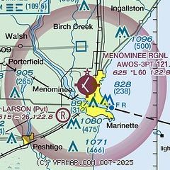
| Sectional chart |
|---|
|
| Airport distance calculator |
|---|
|
|
| Sunrise and sunset |
|---|
|
Times for 06-Mar-2025
| | Local
(UTC-6) | | Zulu
(UTC) |
|---|
| Morning civil twilight | | 05:51 | | 11:51 |
| Sunrise | | 06:21 | | 12:21 |
| Sunset | | 17:43 | | 23:43 |
| Evening civil twilight | | 18:13 | | 00:13 |
|
| Current date and time |
|---|
| Zulu (UTC) | 06-Mar-2025 06:38:10 |
|---|
| Local (UTC-6) | 06-Mar-2025 00:38:10 |
|---|
|
| METAR |
|---|
| KMNM | 060557Z AUTO 33010G18KT 290V360 10SM OVC028 M06/M09 A2952 RMK AO2 PK WND 35026/0522 SLP002 60000 T10611094 11050 21061 53028 FZRANO $
|
KOCQ
19nm SW | 060615Z AUTO 32011G20KT 10SM M05/M10 A2955 RMK AO1 T10551100
|
K3D2
19nm E | 060615Z AUTO 33016G22KT 10SM OVC026 M06/M11 A2948 RMK AO2 T10631107
|
KSUE
19nm SE | 060557Z AUTO 33020G25KT 10SM OVC029 M06/M09 A2950 RMK AO2 PK WND 33030/0542 SNE32 SLP997 P0000 60000 T10561094 11050 21056 400501056 51027 FZRANO
|
|
| TAF |
|---|
KGRB
44nm SW | 060520Z 0606/0706 32014G21KT P6SM BKN030 FM061000 31013G19KT P6SM SCT030 FM061200 29012G18KT P6SM SKC FM062300 26008G15KT P6SM SCT200
|
|
| NOTAMs |
|---|
NOTAMs are issued by the DoD/FAA and will open in a separate window not controlled by AirNav.
|
|


