FAA INFORMATION EFFECTIVE 20 FEBRUARY 2025
Location
| FAA Identifier: | FMM |
| Lat/Long: | 40-20-07.6000N 103-48-15.0000W
40-20.126667N 103-48.250000W
40.3354444,-103.8041667
(estimated) |
| Elevation: | 4595.3 ft. / 1400.6 m (surveyed) |
| Variation: | 08E (2015) |
| From city: | 5 miles N of FORT MORGAN, CO |
| Time zone: | UTC -7 (UTC -6 during Daylight Saving Time) |
| Zip code: | 80701 |
Airport Operations
| Airport use: | Open to the public |
| Activation date: | 04/1940 |
| Control tower: | no |
| ARTCC: | DENVER CENTER |
| FSS: | DENVER FLIGHT SERVICE STATION |
| NOTAMs facility: | DEN (NOTAM-D service available) |
| Attendance: | MON-SAT 0800-1700 |
| Pattern altitude: | 5626.3 ft. MSL |
| Wind indicator: | lighted |
| Segmented circle: | yes |
| Lights: | ACTVT REIL RWY 14 & 32; MIRL RWY 14/32 - CTAF. |
| Beacon: | white-green (lighted land airport)
Operates sunset to sunrise. |
Airport Communications
| CTAF/UNICOM: | 123.05 |
| WX AWOS-3PT: | 132.95 (970-867-1992) |
- APCH/DEP CTL SVC PRVDD BY DENVER ARTCC (ZDV) ON FREQS 118.475/225.4 (BRUSH/B/ RCAG).
Nearby radio navigation aids
| VOR radial/distance | | VOR name | | Freq | | Var |
|---|
| AKOr278/30.6 | | AKRON VOR/DME | | 114.40 | | 13E |
| GLLr093/35.7 | | GILL VOR/DME | | 114.20 | | 13E |
Airport Services
| Fuel available: | 100LL JET-A1
100LL:FUEL AVAILABLE 24/7 WITH CREDIT CARD. |
| Parking: | hangars and tiedowns |
| Airframe service: | NONE |
| Powerplant service: | NONE |
| Bottled oxygen: | NONE |
| Bulk oxygen: | NONE |
Runway Information
Runway 14/32
| Dimensions: | 5731 x 75 ft. / 1747 x 23 m |
| Surface: | asphalt, in good condition |
| Weight bearing capacity: | |
| Runway edge lights: | medium intensity |
| RUNWAY 14 | | RUNWAY 32 |
| Latitude: | 40-20.691088N | | 40-19.861028N |
| Longitude: | 103-48.701502W | | 103-48.115338W |
| Elevation: | 4595.3 ft. | | 4509.3 ft. |
| Traffic pattern: | left | | left |
| Runway heading: | 143 magnetic, 151 true | | 323 magnetic, 331 true |
| Markings: | nonprecision, in good condition | | nonprecision, in good condition |
| Visual slope indicator: | 2-light PAPI on left (3.00 degrees glide path) | | 2-light PAPI on left (3.00 degrees glide path) |
| Runway end identifier lights: | yes | | yes |
| Touchdown point: | yes, no lights | | yes, no lights |
| Obstructions: | none | | 17 ft. road, 393 ft. from runway, 298 ft. right of centerline, 11:1 slope to clear |
Runway 17/35
| Dimensions: | 5216 x 80 ft. / 1590 x 24 m |
| Surface: | turf/dirt, in fair condition |
| RUNWAY 17 | | RUNWAY 35 |
| Latitude: | 40-20.468777N | | 40-19.609973N |
| Longitude: | 103-48.044890W | | 103-48.044445W |
| Elevation: | 4530.7 ft. | | 4501.8 ft. |
| Traffic pattern: | left | | left |
| Runway heading: | 172 magnetic, 180 true | | 352 magnetic, 360 true |
| Touchdown point: | yes, no lights | | yes, no lights |
| Obstructions: | none | | 10 ft. road, 9 ft. from runway |
Runway 8/26
| Dimensions: | 2468 x 100 ft. / 752 x 30 m |
| Surface: | turf, in fair condition |
| RUNWAY 8 | | RUNWAY 26 |
| Latitude: | 40-19.967155N | | 40-19.968163N |
| Longitude: | 103-48.584000W | | 103-48.052997W |
| Elevation: | 4512.2 ft. | | 4509.3 ft. |
| Traffic pattern: | left | | left |
| Runway heading: | 082 magnetic, 090 true | | 262 magnetic, 270 true |
| Touchdown point: | yes, no lights | | yes, no lights |
| Obstructions: | 10 ft. other, 10 ft. from runway
INTERMITTENTLY HAS 5 FT HAY BALES 10 FT FROM AND PARALLEL TO THRESHOLD. | | 18 ft. road, 151 ft. from runway, 8:1 slope to clear |
Airport Ownership and Management from official FAA records
| Ownership: | Publicly-owned |
| Owner: | CITY OF FORT MORGAN
BOX 100 CITY HALL
FORT MORGAN, CO 80701
Phone 970-867-8414 |
| Manager: | KYLE SCOTT
23101 HWY 52
FORT MORGAN, CO 80701
Phone 970-867-8414 |
Additional Remarks
| - | RWY 17/35, 21 ROAD 100 FT E OF AND PARALLEL TO RWY CNTRLN FULL LENGTH. |
| - | BE ALERT, INTENSIVE USAF STUDENT TRNG INVOF COLORADO SPRINGS & PUEBLO COLORADO. |
| - | FOR CD CTC DENVER ARTCC AT 303-651-4257. |
Instrument Procedures
NOTE: All procedures below are presented as PDF files. If you need a reader for these files, you should download the free Adobe Reader.NOT FOR NAVIGATION. Please procure official charts for flight.
FAA instrument procedures published for use from 20 February 2025 at 0901Z to 20 March 2025 at 0900Z.
IAPs - Instrument Approach Procedures |
|---|
| RNAV (GPS) RWY 14 | |
download (211KB) |
| RNAV (GPS) RWY 32 | |
download (232KB) |
| NOTE: Special Alternate Minimums apply | |
download (36KB) |
| NOTE: Special Take-Off Minimums/Departure Procedures apply | |
download (141KB) |
Other nearby airports with instrument procedures:
KAKO - Colorado Plains Regional Airport (28 nm E)
KSTK - Sterling Municipal Airport (30 nm NE)
KGXY - Greeley-Weld County Airport (38 nm W)
KCFO - Colorado Air and Space Port Airport (47 nm SW)
KDEN - Denver International Airport (49 nm SW)
|
|

Road maps at:
MapQuest
Bing
Google
| Aerial photo |
|---|
WARNING: Photo may not be current or correct
 Photo by Tavo Gutierrez
Photo taken 03-Jul-2011
looking south.
Photo by Tavo Gutierrez
Photo taken 03-Jul-2011
looking south.
Do you have a better or more recent aerial photo of Fort Morgan Municipal Airport that you would like to share? If so, please send us your photo.
|
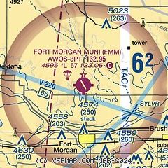
| Sectional chart |
|---|
|
| Airport distance calculator |
|---|
|
|
| Sunrise and sunset |
|---|
|
Times for 05-Mar-2025
| | Local
(UTC-7) | | Zulu
(UTC) |
|---|
| Morning civil twilight | | 05:56 | | 12:56 |
| Sunrise | | 06:24 | | 13:24 |
| Sunset | | 17:50 | | 00:50 |
| Evening civil twilight | | 18:17 | | 01:17 |
|
| Current date and time |
|---|
| Zulu (UTC) | 06-Mar-2025 03:22:22 |
|---|
| Local (UTC-7) | 05-Mar-2025 20:22:22 |
|---|
|
| METAR |
|---|
| KFMM | 060255Z AUTO 18005KT 10SM FEW070 SCT075 BKN100 06/M02 A2990 RMK AO2
|
|
| TAF |
|---|
KDEN
49nm SW | 060203Z 0602/0706 13012KT P6SM BKN120 OVC220 FM060400 17010KT P6SM BKN080 OVC150 FM061000 27007KT P6SM SCT040 BKN100 BKN150 TEMPO 0611/0615 2SM BR BKN010 FM061500 VRB05KT P6SM FEW050 SCT100 BKN200 FM062100 09007KT P6SM FEW060 SCT120 BKN200 FM070100 01010KT P6SM VCSH SCT040 BKN070 OVC120
|
|
| NOTAMs |
|---|
NOTAMs are issued by the DoD/FAA and will open in a separate window not controlled by AirNav.
|
|


