FAA INFORMATION EFFECTIVE 17 APRIL 2025
Location
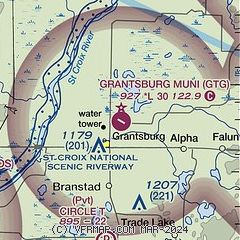
| FAA Identifier: | GTG |
| Lat/Long: | 45-47-54.1603N 092-39-51.5913W
45-47.902672N 092-39.859855W
45.7983779,-92.6643309
(estimated) |
| Elevation: | 927.1 ft. / 282.6 m (surveyed) |
| Variation: | 00E (2015) |
| From city: | 2 miles NE of GRANTSBURG, WI |
| Time zone: | UTC -5 (UTC -6 during Standard Time) |
| Zip code: | 54840 |
Airport Operations
| Airport use: | Open to the public |
| Activation date: | 10/1946 |
| Control tower: | no |
| ARTCC: | MINNEAPOLIS CENTER |
| FSS: | GREEN BAY FLIGHT SERVICE STATION |
| NOTAMs facility: | GRB (NOTAM-D service available) |
| Attendance: | UNATNDD |
| Wind indicator: | lighted |
| Segmented circle: | yes |
| Lights: | ACTVT MIRL RWY 12/30 - CTAF. |
| Beacon: | white-green (lighted land airport)
Operates sunset to sunrise. |
Airport Communications
| CTAF: | 122.9 |
| WX AWOS-3 at RZN (12 nm E): | 118.325 (715-349-8563) |
| WX AWOS-3 at ROS (13 nm SW): | 118.8 (320-358-3339) |
| WX AWOS-3 at 04W (17 nm NW): | 118.225 (320-384-6169) |
- APCH/DEP SVC PRVDD BY MINNEAPOLIS ARTCC ON FREQS 121.05/235.775 (PRINCETON RCAG).
Nearby radio navigation aids
| NDB name | | Hdg/Dist | | Freq | | Var | | ID |
|---|
| BIG DOCTOR | | 265/12.5 | | 203 | | 01W | | BXR | -... -..- .-. |
Airport Services
| Parking: | tiedowns |
| Bottled oxygen: | NONE |
| Bulk oxygen: | NONE |
Runway Information
Runway 12/30
| Dimensions: | 2999 x 60 ft. / 914 x 18 m |
| Surface: | asphalt, in poor condition
NUMEROUS CRACKS AND VEGETATION IN PAVEMENT. |
| Runway edge lights: | medium intensity |
| Runway edge markings: | MARKINGS FADED. |
| RUNWAY 12 | | RUNWAY 30 |
| Latitude: | 45-48.009868N | | 45-47.757857N |
| Longitude: | 092-40.164380W | | 092-39.557783W |
| Elevation: | 924.2 ft. | | 923.6 ft. |
| Traffic pattern: | left | | left |
| Runway heading: | 121 | | 301 |
| Markings: | nonprecision, in poor condition | | nonprecision, in poor condition |
| Runway end identifier lights: | no | | no |
| Touchdown point: | yes, no lights | | yes, no lights |
| Obstructions: | 20 ft. trees, 330 ft. from runway, 225 ft. left of centerline, 6:1 slope to clear | | 50 ft. trees, 700 ft. from runway, 300 ft. left of centerline, 10:1 slope to clear |
Runway 5/23
| Dimensions: | 3280 x 120 ft. / 1000 x 37 m |
| Surface: | turf, in fair condition |
| Runway edge markings: | RWY 05/23 MKD WITH YELLOW CONES. |
| Operational restrictions: | CLSD NOV 1 - APR 15. |
| RUNWAY 5 | | RUNWAY 23 |
| Latitude: | 45-47.767755N | | 45-48.071982N |
| Longitude: | 092-40.177310W | | 092-39.540155W |
| Elevation: | 924.1 ft. | | 924.2 ft. |
| Traffic pattern: | left | | left |
| Runway heading: | 056 | | 236 |
| Touchdown point: | yes, no lights | | yes, no lights |
| Obstructions: | none | | 30 ft. trees, 225 ft. from runway, 125 ft. right of centerline, 7:1 slope to clear |
Airport Ownership and Management from official FAA records
| Ownership: | Publicly-owned |
| Owner: | VILLAGE OF GRANTSBURG
316 S. BRAD ST
GRANTSBURG, WI 54840
Phone 715-463-2405 |
| Manager: | SHEILA MEYER
316 S. BRAD ST
GRANTSBURG, WI 54840
Phone 715-463-2405
EMAIL ADDRESS: OFFICE@VILLAGEOFGRANTSBURG.GOV |
Additional Remarks
| - | DEER & WATERFOWL ON AND INVOF ARPT. |
| - | 1100 FT MSL/182 FT AGL WATER TWR LCTD 5060 FT SW RWY 05. |
| - | FOR CD CTC MINNEAPOLIS ARTCC AT 651-463-5588. |
Instrument Procedures
NOTE: All procedures below are presented as PDF files. If you need a reader for these files, you should download the free Adobe Reader.NOT FOR NAVIGATION. Please procure official charts for flight.
FAA instrument procedures published for use from 17 April 2025 at 0901Z to 15 May 2025 at 0900z.
IAPs - Instrument Approach Procedures |
|---|
| RNAV (GPS) RWY 12 | |
download (199KB) |
| RNAV (GPS) RWY 30 | |
download (214KB) |
| NOTE: Special Take-Off Minimums/Departure Procedures apply | |
download (201KB) |
Other nearby airports with instrument procedures:
KRZN - Burnett County Airport (12 nm E)
KROS - Rush City Regional Airport (13 nm SW)
04W - Field of Dreams Airport (17 nm NW)
KJMR - Mora Municipal Airport (26 nm W)
KCBG - Cambridge Municipal Airport (29 nm SW)
|
|

Road maps at:
MapQuest
Bing
Google
| Aerial photo |
|---|
WARNING: Photo may not be current or correct

Do you have a better or more recent aerial photo of Grantsburg Municipal Airport that you would like to share? If so, please send us your photo.
|
| Sectional chart |
|---|
|
| Airport distance calculator |
|---|
|
|
| Sunrise and sunset |
|---|
|
Times for 20-Apr-2025
| | Local
(UTC-5) | | Zulu
(UTC) |
|---|
| Morning civil twilight | | 05:45 | | 10:45 |
| Sunrise | | 06:17 | | 11:17 |
| Sunset | | 20:02 | | 01:02 |
| Evening civil twilight | | 20:34 | | 01:34 |
|
| Current date and time |
|---|
| Zulu (UTC) | 20-Apr-2025 18:24:13 |
|---|
| Local (UTC-5) | 20-Apr-2025 13:24:13 |
|---|
|
| METAR |
|---|
KRZN
12nm E | 201755Z AUTO 15008KT 10SM CLR 11/M03 A3023 RMK AO2 T01111031 10112 21041
|
KROS
13nm SW | 201755Z AUTO 12008KT 10SM CLR 11/M03 A3022 RMK AO2
|
K04W
17nm NW | 201755Z AUTO 15005KT 10SM CLR 11/M04 A3023 RMK AO2
|
|
| TAF |
|---|
KRNH
39nm S | 201740Z 2018/2118 12008KT P6SM OVC150 FM202300 11009KT 4SM -RA BR OVC022 FM210300 08012G20KT 2SM -RA BR OVC008 FM210800 01012G21KT 2SM -RA BR OVC008 FM211100 34012G20KT 6SM -RA BR OVC007 FM211600 33014G22KT P6SM OVC012
|
|
| NOTAMs |
|---|
NOTAMs are issued by the DoD/FAA and will open in a separate window not controlled by AirNav.
|
|


