FAA INFORMATION EFFECTIVE 23 JANUARY 2025
Location
| FAA Identifier: | HBI |
| Lat/Long: | 35-39-16.2900N 079-53-41.0540W
35-39.271500N 079-53.684233W
35.6545250,-79.8947372
(estimated) |
| Elevation: | 670.8 ft. / 204.5 m (surveyed) |
| Variation: | 08W (2000) |
| From city: | 6 miles SW of ASHEBORO, NC |
| Time zone: | UTC -5 (UTC -4 during Daylight Saving Time) |
| Zip code: | 27203 |
Airport Operations
| Airport use: | Open to the public |
| Activation date: | 08/1965 |
| Control tower: | no |
| ARTCC: | ATLANTA CENTER |
| FSS: | RALEIGH FLIGHT SERVICE STATION |
| NOTAMs facility: | HBI (NOTAM-D service available) |
| Attendance: | OCT-MAY 0800-DUSK, JUNE-SEPT 0800-2000 |
| Wind indicator: | lighted |
| Segmented circle: | yes |
| Lights: | DUSK-2300; ACTVT REIL RWY 03 & 21; PAPI RWY 03 & 21; AND AFTER 2300, MIRL RWY 03/21 - CTAF. |
| Beacon: | white-green (lighted land airport)
Operates sunset to sunrise. |
Airport Communications
| CTAF/UNICOM: | 122.8 |
| WX AWOS-3: | 119.275 (336-626-7933) |
| GREENSBORO APPROACH: | 126.6 |
| GREENSBORO DEPARTURE: | 126.6 |
| WX AWOS-3 at VUJ (19 nm SW): | 128.175 (704-986-2097) |
| WX AWOS-3 at SCR (19 nm E): | 125.775 (919-663-1252) |
Nearby radio navigation aids
| VOR radial/distance | | VOR name | | Freq | | Var |
|---|
| LIBr239/16.7 | | LIBERTY VORTAC | | 113.00 | | 03W |
| GSOr173/23.8 | | GREENSBORO VORTAC | | 116.20 | | 03W |
| SDZr333/30.3 | | SANDHILLS VORTAC | | 111.80 | | 03W |
| NDB name | | Hdg/Dist | | Freq | | Var | | ID |
|---|
| ALLER | | 049/13.5 | | 346 | | 06W | | VU | ...- ..- |
Airport Services
| Fuel available: | 100LL JET-A1+
100LL:100LL & JET A 24 HR SELF SVC AVBL WITH CREDIT CARD. |
| Parking: | hangars and tiedowns |
| Airframe service: | MAJOR |
| Powerplant service: | MAJOR |
| Bottled oxygen: | NONE |
| Bulk oxygen: | NONE |
Runway Information
Runway 3/21
| Dimensions: | 5501 x 100 ft. / 1677 x 30 m |
| Surface: | asphalt, in good condition |
| Weight bearing capacity: | | Single wheel: | 30.0 | | Double wheel: | 60.0 |
|
| Runway edge lights: | medium intensity |
| RUNWAY 3 | | RUNWAY 21 |
| Latitude: | 35-38.849812N | | 35-39.693195N |
| Longitude: | 079-53.888153W | | 079-53.480270W |
| Elevation: | 670.8 ft. | | 668.1 ft. |
| Traffic pattern: | left | | left |
| Runway heading: | 030 magnetic, 022 true | | 210 magnetic, 202 true |
| Markings: | nonprecision, in good condition | | nonprecision, in good condition |
| Visual slope indicator: | 2-light PAPI on left (3.50 degrees glide path) | | 2-light PAPI on left (3.00 degrees glide path) |
| Runway end identifier lights: | yes | | yes |
| Touchdown point: | yes, no lights | | yes, no lights |
| Obstructions: | 398 ft. trees, 8976 ft. from runway, 533 ft. right of centerline, 22:1 slope to clear | | 55 ft. trees, 1891 ft. from runway, 273 ft. left of centerline, 30:1 slope to clear
HAS 11 FT GND 0-200 FT FM THR 241 FT RIGHT OF CNTRLN. |
Airport Ownership and Management from official FAA records
| Ownership: | Publicly-owned |
| Owner: | CITY OF ASHEBORO
P. O. BOX 1106
ASHEBORO, NC 27204-1106
Phone 336-626-1201 |
| Manager: | KAREN MCCRAW
2222 PILOTS VIEW RD
ASHEBORO, NC 27205-1106
Phone 336-625-6120
FOR SVC AFTER HOURS CALL 919-619-2707. |
Additional Remarks
| - | TRRN RISING SOUTH OF THE ARPT. |
| - | RWY 03 HAS 40 FT DROP-OFF 400 FT FM THR; 0B. |
| - | NORTH CAROLINA AVIATION MUSEUM HALL OF FAME LCTD ON FLD. |
| - | FOR CD CTC GREENSBORO APCH AT 743-222-6129. |
Instrument Procedures
NOTE: All procedures below are presented as PDF files. If you need a reader for these files, you should download the free Adobe Reader.NOT FOR NAVIGATION. Please procure official charts for flight.
FAA instrument procedures published for use from 23 January 2025 at 0901Z to 20 February 2025 at 0900z.
IAPs - Instrument Approach Procedures |
|---|
| RNAV (GPS) RWY 03 | |
download (222KB) |
| RNAV (GPS) RWY 21 | |
download (207KB) |
| NOTE: Special Alternate Minimums apply | |
download (166KB) |
| NOTE: Special Take-Off Minimums/Departure Procedures apply | |
download (141KB) |
Other nearby airports with instrument procedures:
43A - Montgomery County Airport (17 nm S)
KVUJ - Stanly County Airport (19 nm SW)
KSCR - Siler City Municipal Airport (19 nm E)
KEXX - Davidson County Executive Airport (21 nm W)
KGSO - Piedmont Triad International Airport (27 nm N)
|
|

Road maps at:
MapQuest
Bing
Google
| Aerial photo |
|---|
WARNING: Photo may not be current or correct
 Photo taken 12-Sep-2010
looking south.
Photo taken 12-Sep-2010
looking south.
Do you have a better or more recent aerial photo of Asheboro Regional Airport that you would like to share? If so, please send us your photo.
|
| Sectional chart |
|---|
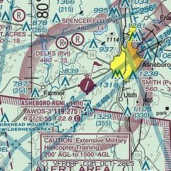
|
| Airport distance calculator |
|---|
|
|
| Sunrise and sunset |
|---|
|
Times for 06-Feb-2025
| | Local
(UTC-5) | | Zulu
(UTC) |
|---|
| Morning civil twilight | | 06:50 | | 11:50 |
| Sunrise | | 07:16 | | 12:16 |
| Sunset | | 17:51 | | 22:51 |
| Evening civil twilight | | 18:18 | | 23:18 |
|
| Current date and time |
|---|
| Zulu (UTC) | 06-Feb-2025 13:28:43 |
|---|
| Local (UTC-5) | 06-Feb-2025 08:28:43 |
|---|
|
| METAR |
|---|
| KHBI | 061310Z AUTO 19004KT 10SM OVC018 06/03 A3014 RMK AO2 T00560027
|
KVUJ
19nm SW | 061305Z AUTO 17004KT 10SM OVC011 07/04 A3016 RMK AO2 LTG DSNT E T00650040
|
|
| TAF |
|---|
KGSO
27nm N | 061131Z 0612/0712 VRB05KT P6SM BKN015 OVC030 TEMPO 0612/0615 6SM -SHRA BR BKN015 OVC040 FM061500 23011G18KT P6SM BKN030 BKN080 FM061800 24011G18KT P6SM SCT035 BKN080 FM062300 23006KT P6SM BKN050 FM070300 23003KT P6SM VCSH BKN060 FM070700 28006KT P6SM SCT030 BKN070
|
KINT
33nm NW | 061131Z 0612/0712 VRB05KT P6SM BKN030 OVC050 TEMPO 0612/0615 6SM -SHRA BR BKN015 OVC040 FM061500 23009G16KT P6SM BKN030 BKN080 FM061800 24011G18KT P6SM SCT035 BKN080 FM062300 22005KT P6SM BKN050 FM070300 23003KT P6SM VCSH BKN060 FM070700 28006KT P6SM SCT030 BKN070
|
|
| NOTAMs |
|---|
NOTAMs are issued by the DoD/FAA and will open in a separate window not controlled by AirNav.
|
|


