FAA INFORMATION EFFECTIVE 20 FEBRUARY 2025
Location
| FAA Identifier: | PDK |
| Lat/Long: | 33-52-33.6070N 084-18-07.3100W
33-52.560117N 084-18.121833W
33.8760019,-84.3020306
(estimated) |
| Elevation: | 998.4 ft. / 304.3 m (surveyed) |
| Variation: | 05W (2015) |
| From city: | 8 miles NE of ATLANTA, GA |
| Time zone: | UTC -5 (UTC -4 during Daylight Saving Time) |
| Zip code: | 30341 |
Airport Operations
| Airport use: | Open to the public |
| Control tower: | yes |
| ARTCC: | ATLANTA CENTER |
| FSS: | MACON FLIGHT SERVICE STATION |
| NOTAMs facility: | PDK (NOTAM-D service available) |
| Attendance: | CONTINUOUS |
| Wind indicator: | lighted |
| Segmented circle: | no |
| Lights: | PERIMETER LGTS H1 OPER DUSK-DAWN. REIL RWY 03R; VASI RWY 03R, 16, 34; PAPI RWY 03L, 21L, 21R; MIRL RWY 03L/21R, 16/34 - OPR DRG TWR HRS. WHEN ATCT CLSD HIRL RWY 03R/21L PRESET MED INTST; TO INCR INTST & ACTVT MALSF RWY 21L AND TWY LGTS - 120.0. |
| Beacon: | white-green (lighted land airport)
Operates sunset to sunrise. |
| Airline operations: | ARFF ON FIELD, NO INDEX. |
| International operations: | customs landing rights airport |
Airport Communications
| CTAF: | 120.9 |
| UNICOM: | 122.95 |
| ATIS: | 128.4 |
| WX ASOS: | 128.4 (770-457-1691) |
| PEACHTREE GROUND: | 121.6 [0630-2300 MON-FRI 0700-2300 SAT & SUN] |
| PEACHTREE TOWER: | 120.9 281.5 127.2 [0630-2300 MON-FRI 0700-2300 SAT & SUN] |
| ATLANTA APPROACH: | 126.975 |
| ATLANTA DEPARTURE: | 126.975 |
| CLEARANCE DELIVERY: | 125.2 120.9 |
| BOKRT STAR: | 119.8 |
| WRGNZ STAR: | 128.575 |
| WX ASOS at FTY (12 nm SW): | PHONE 404-696-5660 |
| WX ASOS at ATL (16 nm SW): | PHONE 404-559-5166 |
| WX AWOS-3PT at RYY (17 nm NW): | PHONE 770-425-3406 |
| WX AWOS-3PT at LZU (18 nm E): | PHONE 770-339-7753 |
Nearby radio navigation aids
| NDB name | | Hdg/Dist | | Freq | | Var | | ID |
|---|
| BARROW COUNTY | | 269/35.7 | | 404 | | 05W | | BMW | -... -- .-- |
| PECAT | | 020/35.7 | | 316 | | 05W | | FFC | ..-. ..-. -.-. |
Airport Services
| Fuel available: | 100LL JET-A JET-A+ |
| Parking: | hangars and tiedowns |
| Airframe service: | MAJOR |
| Powerplant service: | MAJOR |
| Bottled oxygen: | HIGH/LOW |
| Bulk oxygen: | HIGH/LOW |
Runway Information
Runway 3R/21L
| Dimensions: | 6001 x 100 ft. / 1829 x 30 m |
| Surface: | concrete/grooved, in good condition |
| Weight bearing capacity: | | Single wheel: | 46.0 | | Double wheel: | 75.0 |
|
| Runway edge lights: | high intensity |
| RUNWAY 3R | | RUNWAY 21L |
| Latitude: | 33-52.115458N | | 33-53.042128N |
| Longitude: | 084-18.239513W | | 084-17.824015W |
| Elevation: | 995.5 ft. | | 982.6 ft. |
| Traffic pattern: | right | | left |
| Runway heading: | 026 magnetic, 021 true | | 206 magnetic, 201 true |
| Displaced threshold: | no | | 1005 ft. |
| Declared distances: | TORA:5411 TODA:6001 ASDA:5411 LDA:5411 | | TORA:6001 TODA:6001 ASDA:6001 LDA:5001 |
| Markings: | precision, in good condition | | precision, in good condition |
| Visual slope indicator: | 4-box VASI on left (3.00 degrees glide path) | | 2-light PAPI on right (3.00 degrees glide path) |
| RVR equipment: | rollout | | touchdown |
| Approach lights: | | | MALSF: 1,400 foot medium intensity approach lighting system with sequenced flashers |
| Runway end identifier lights: | yes | | no |
| Touchdown point: | yes, no lights | | yes, no lights |
| Instrument approach: | | | ILS |
| Obstructions: | 1 ft. bldg, 201 ft. from runway, 452 ft. right of centerline, 1:1 slope to clear | | 40 ft. pole, 556 ft. from runway, 338 ft. right of centerline, 8:1 slope to clear
RWY 21L APCH RATIO 32:1 TO DSPLCD THLD. |
Runway 16/34
| Dimensions: | 3968 x 150 ft. / 1209 x 46 m |
| Surface: | asphalt, in excellent condition |
| Weight bearing capacity: | |
| Runway edge lights: | medium intensity |
| RUNWAY 16 | | RUNWAY 34 |
| Latitude: | 33-52.960582N | | 33-52.356610N |
| Longitude: | 084-18.329420W | | 084-18.027893W |
| Elevation: | 998.1 ft. | | 991.2 ft. |
| Traffic pattern: | left | | left |
| Runway heading: | 162 magnetic, 157 true | | 342 magnetic, 337 true |
| Markings: | basic, in good condition | | basic, in good condition |
| Visual slope indicator: | 4-box VASI on left (3.40 degrees glide path) | | 4-box VASI on left (3.30 degrees glide path) |
| Runway end identifier lights: | no | | no |
| Touchdown point: | yes, no lights | | yes, no lights |
| Obstructions: | 86 ft. trees, 1703 ft. from runway, 95 ft. left of centerline, 17:1 slope to clear | | 41 ft. trees, 366 ft. from runway, 97 ft. left of centerline, 4:1 slope to clear |
Runway 3L/21R
| Dimensions: | 3746 x 150 ft. / 1142 x 46 m |
| Surface: | asphalt, in fair condition |
| Weight bearing capacity: | |
| Runway edge lights: | medium intensity |
| RUNWAY 3L | | RUNWAY 21R |
| Latitude: | 33-52.136633N | | 33-52.715018N |
| Longitude: | 084-18.335595W | | 084-18.076218W |
| Elevation: | 990.2 ft. | | 976.6 ft. |
| Traffic pattern: | left | | right |
| Runway heading: | 026 magnetic, 021 true | | 206 magnetic, 201 true |
| Markings: | basic, in good condition | | basic, in good condition |
| Visual slope indicator: | 2-light PAPI on left (3.00 degrees glide path) | | 2-light PAPI on left (3.00 degrees glide path) |
| Touchdown point: | yes, no lights | | yes, no lights |
| Obstructions: | 49 ft. trees, 1310 ft. from runway, 65 ft. left of centerline, 22:1 slope to clear | | none |
Helipad H1
| Dimensions: | 56 x 56 ft. / 17 x 17 m |
| Surface: | concrete, in good condition |
| Runway edge lights: | PERI |
| Latitude: | 33-53.049667N | | |
| Longitude: | 084-18.374167W | | |
| Elevation: | 998.2 ft. | | |
| Traffic pattern: | left | | left |
Airport Ownership and Management from official FAA records
| Ownership: | Publicly-owned |
| Owner: | DEKALB COUNTY
1300 COMMERCE DR / SUITE 600
DECATUR, GA 30030
Phone 770-936-5440 |
| Manager: | HUNTER HINES
2000 AIRPORT RD / RM 212
ATLANTA, GA 30341
Phone 770-936-5440 |
Additional Remarks
| E60-21L | ENGINEERED MATERIALS ARRESTING SYSTEM, 160 FT IN WIDE 600 FT IN LENGTH, LOCATED AT DEPARTURE END OF RWY 21L. |
| - | VOLUNTARY NIGHT CURFEW IN EFFECT FROM 2300-0600. NO HIGH POWER ENGINE/MAINTENANCE RUNUPS FROM 2200-0700. |
| - | NOISE SENSITIVE AREAS ALL QUADRANTS. PILOTS USE CLOSE-IN DEPARTURE PROCEDURES. |
| - | HEAVY VFR HELO OPS NW CORNER AND EASTSIDE OF ARPT. HELI LCTD NORTH OF RY 16 THLD. |
| - | PPR FOR ALL TRANSIENT MIL ACFT. |
| - | PPR FOR ACFT WITH MAX GROSS CERTIF WEIGHT MORE THAN 75,000 LBS. |
| - | BE ALERT DURG ACFT GRND OPS. MULTIPLE RY/TWY CROSSINGS REQUIRED. |
| - | BE ALERT: PILOTS SHOULD BE ALERT WHEN OPERATING AT PDK DUE TO HIGH NUMBER OF RY INCURSIONS. |
| - | ALL TWY K AND ALL TWY L AND TWY C EAST OF TWY D ARE NON-MOVEMENT AREAS. |
Instrument Procedures
NOTE: All procedures below are presented as PDF files. If you need a reader for these files, you should download the free Adobe Reader.NOT FOR NAVIGATION. Please procure official charts for flight.
FAA instrument procedures published for use from 20 February 2025 at 0901Z to 20 March 2025 at 0900Z.
STARs - Standard Terminal Arrivals |
|---|
| BOKRT THREE (RNAV) | |
download (185KB) |
| BUKHD THREE (RNAV) | |
download (190KB) |
| DEHAN THREE (RNAV) | |
2 pages:
[1] [2] (325KB) |
| SWTEE TWO (RNAV) | |
download (142KB) |
| WRGNZ THREE (RNAV) | |
download (245KB) |
IAPs - Instrument Approach Procedures |
|---|
| ILS OR LOC RWY 21L | |
download (310KB) |
| RNAV (RNP) RWY 03R | |
download (280KB) |
| RNAV (RNP) Z RWY 21L | |
download (263KB) |
| RNAV (GPS) Y RWY 21L | |
download (302KB) |
| RNAV (GPS)-A | |
download (202KB) |
| NOTE: Special Alternate Minimums apply | |
download (138KB) |
| NOTE: Special Take-Off Minimums/Departure Procedures apply | |
download (491KB) |
Other nearby airports with instrument procedures:
KMGE - Dobbins ARB Airport (11 nm W)
KFTY - Fulton County Executive Airport/Charlie Brown Field (12 nm SW)
KATL - Hartsfield/Jackson Atlanta International Airport (16 nm SW)
KRYY - Cobb County International Airport-McCollum Field (17 nm NW)
KLZU - Gwinnett County Airport-Briscoe Field (18 nm E)
|
|

Road maps at:
MapQuest
Bing
Google
| Aerial photo |
|---|
WARNING: Photo may not be current or correct
 Photo courtesy of AirNav, LLC
Photo taken 28-Jun-2017
looking northwest.
Photo courtesy of AirNav, LLC
Photo taken 28-Jun-2017
looking northwest.
Do you have a better or more recent aerial photo of Dekalb-Peachtree Airport that you would like to share? If so, please send us your photo.
|
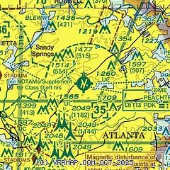
| Sectional chart |
|---|
|
CAUTION: Diagram may not be current
 Download PDF
of official airport diagram from the FAA
| Airport distance calculator |
|---|
|
|
| Sunrise and sunset |
|---|
|
Times for 13-Mar-2025
| | Local
(UTC-5) | | Zulu
(UTC) |
|---|
| Morning civil twilight | | 06:26 | | 11:26 |
| Sunrise | | 06:51 | | 11:51 |
| Sunset | | 18:42 | | 23:42 |
| Evening civil twilight | | 19:07 | | 00:07 |
|
| Current date and time |
|---|
| Zulu (UTC) | 13-Mar-2025 19:31:44 |
|---|
| Local (UTC-5) | 13-Mar-2025 14:31:44 |
|---|
|
| METAR |
|---|
| KPDK | 131853Z 20007KT 170V230 10SM FEW040 21/12 A2992 RMK AO2 SLP126 T02060122
|
KMGE
11nm W | 131900Z 19008KT 10SM TS BKN036CB OVC120 21/13 A2990 RMK AO2A OCNL LTGICCCCG TS 5N MOV NE SLP123 $
|
KFTY
12nm SW | 131853Z 24009KT 10SM FEW035 SCT048 BKN060 23/12 A2992 RMK AO2 SLP127 T02280117
|
KATL
16nm SW | 131852Z 22011G16KT 10SM FEW033TCU SCT060 BKN200 BKN250 22/13 A2994 RMK AO2 SLP133 CB DSNT N SW TCU N E NW DSNT SE-SW MDT CU NE NW T02170128 $
|
KRYY
17nm NW | 131908Z 00000KT 10SM -TSRA BKN039 OVC050 18/14 A2993 RMK AO2 TSB02 P0009 $
|
KLZU
18nm E | 131856Z 20007KT 10SM FEW045 SCT050 22/11 A2992 RMK AO2 SLP138 T02220111
|
|
| TAF |
|---|
| KPDK | 131736Z 1318/1418 23009KT P6SM SCT030 BKN120 FM131900 22009KT P6SM VCSH SCT090 PROB30 1320/1324 5SM -TSRA BKN050CB FM141000 00000KT P6SM BKN200 FM141600 15010KT P6SM BKN250
|
KMGE
11nm W | 131300Z 1313/1419 VRB06KT 9999 SCT100 OVC200 QNH2991INS BECMG 1315/1316 24010KT 9999 SCT100 OVC150 QNH2992INS BECMG 1317/1318 23010KT 9999 VCSH BKN020 OVC050 QNH2990INS BECMG 1319/1320 23010KT 8000 -SHRA VCTS BKN020CB OVC050 QNH2988INS BECMG 1323/1324 VRB06KT 9999 NSW SCT025 BKN050 QNH2991INS BECMG 1407/1408 VRB06KT 8000 BR SCT010 BKN020 QNH2990INS BECMG 1413/1414 VRB06KT 3200 BR BKN007 OVC015 QNH2992INS BECMG 1418/1419 16010G15KT 9999 NSW SCT015 BKN020 QNH2992INS TX22/1320Z TN11/1313Z
|
KFTY
12nm SW | 131736Z 1318/1418 23009KT P6SM SCT030 BKN090 FM131900 22009KT P6SM VCSH SCT050 PROB30 1320/1324 5SM -TSRA BKN060CB FM140000 VRB03KT P6SM FEW250 FM141600 15010KT P6SM BKN250
|
KATL
16nm SW | 131736Z 1318/1424 23010KT P6SM SCT025 BKN050 FM131900 23010KT P6SM VCSH SCT030 BKN120 PROB30 1320/1324 5SM -TSRA BKN060CB FM140000 22005KT P6SM FEW250 FM140700 19003KT P6SM SCT006 SCT250 FM141000 15005KT 5SM BR BKN006 FM141500 15010KT P6SM FEW025 SCT250
|
KRYY
17nm NW | 131736Z 1318/1418 22008KT P6SM SCT070 BKN150 FM131900 22006KT P6SM VCSH SCT120 FM140000 20004KT P6SM FEW250 FM141600 15010KT P6SM BKN250
|
|
| NOTAMs |
|---|
NOTAMs are issued by the DoD/FAA and will open in a separate window not controlled by AirNav.
|
|


