FAA INFORMATION EFFECTIVE 23 JANUARY 2025
Location
| FAA Identifier: | SIF |
| Lat/Long: | 36-26-13.9790N 079-51-03.6350W
36-26.232983N 079-51.060583W
36.4372164,-79.8510097
(estimated) |
| Elevation: | 693.5 ft. / 211.4 m (surveyed) |
| Variation: | 07W (1990) |
| From city: | 8 miles NW of REIDSVILLE, NC |
| Time zone: | UTC -5 (UTC -4 during Daylight Saving Time) |
| Zip code: | 27048 |
Airport Operations
| Airport use: | Open to the public |
| Activation date: | 12/1975 |
| Control tower: | no |
| ARTCC: | ATLANTA CENTER |
| FSS: | RALEIGH FLIGHT SERVICE STATION |
| NOTAMs facility: | SIF (NOTAM-D service available) |
| Attendance: | 0800-1700 |
| Wind indicator: | lighted |
| Segmented circle: | yes |
| Lights: | ACTVT REIL RWY 13 & 31; PAPI RWY 13 & 31; HIRL RWY 13/31 - CTAF. |
| Beacon: | white-green (lighted land airport)
Operates sunset to sunrise. |
Airport Communications
| CTAF/UNICOM: | 122.8 |
| WX AWOS-3: | 119.775 (336-573-3677) |
| GREENSBORO APPROACH: | 124.35 |
| GREENSBORO DEPARTURE: | 124.35 |
| WX AWOS-3 at MTV (14 nm NW): | 118.45 (276-957-3784) |
Nearby radio navigation aids
| VOR radial/distance | | VOR name | | Freq | | Var |
|---|
| GSOr017/24.3 | | GREENSBORO VORTAC | | 116.20 | | 03W |
| LIBr346/39.3 | | LIBERTY VORTAC | | 113.00 | | 03W |
| NDB name | | Hdg/Dist | | Freq | | Var | | ID |
|---|
| SLAMMER | | 315/5.4 | | 423 | | 07W | | SIF | ... .. ..-. |
| BALES | | 168/9.7 | | 396 | | 07W | | UV | ..- ...- |
Airport Services
| Fuel available: | 100LL JET-A1+
100LL:100LL FUEL 24 HR CREDIT CARD SVC AVBL. |
| Parking: | tiedowns |
| Airframe service: | MAJOR |
| Powerplant service: | MAJOR |
| Bottled oxygen: | NONE |
| Bulk oxygen: | NONE |
Runway Information
Runway 13/31
| Dimensions: | 5200 x 100 ft. / 1585 x 30 m |
| Surface: | asphalt, in good condition |
| Weight bearing capacity: | | Single wheel: | 32.0 | | Double wheel: | 43.0 |
|
| Runway edge lights: | high intensity |
| RUNWAY 13 | | RUNWAY 31 |
| Latitude: | 36-26.476170N | | 36-25.989755N |
| Longitude: | 079-51.497150W | | 079-50.624055W |
| Elevation: | 693.5 ft. | | 667.9 ft. |
| Traffic pattern: | left | | left |
| Runway heading: | 132 magnetic, 125 true | | 312 magnetic, 305 true |
| Displaced threshold: | 500 ft. | | no |
| Markings: | nonprecision, in good condition | | nonprecision, in good condition |
| Visual slope indicator: | 4-light PAPI on left (3.70 degrees glide path) | | 4-light PAPI on left (3.70 degrees glide path) |
| Runway end identifier lights: | yes | | yes |
| Touchdown point: | yes, no lights | | yes, no lights |
| Instrument approach: | | | SDF |
| Obstructions: | 83 ft. trees, 671 ft. from runway, 320 ft. right of centerline, 5:1 slope to clear
5 FT GND 0-200 FT FROM THR 150 FT RIGHT OF CNTRLN. | | 55 ft. trees, 893 ft. from runway, 211 ft. right of centerline, 12:1 slope to clear |
Airport Ownership and Management from official FAA records
| Ownership: | Publicly-owned |
| Owner: | ROCKINGHAM COUNTY
2691 SETTLE BRIDGE ROAD
STONEVILLE, NC 27048
Phone 336-573-3115 |
| Manager: | MIKE BROOKS
2691 SETTLE BRIDGE ROAD
STONEVILLE, NC 27048
Phone 336-573-3115
FAX 336-573-9415. |
Additional Remarks
| - | DEER ON & INVOF ARPT. |
| - | FOR CD CTC GREENSBORO APCH AT 743-222-6129. |
| - | SEASONAL FARMING OPNS AND EQPT INVOF RWY. |
Instrument Procedures
NOTE: All procedures below are presented as PDF files. If you need a reader for these files, you should download the free Adobe Reader.NOT FOR NAVIGATION. Please procure official charts for flight.
FAA instrument procedures published for use from 23 January 2025 at 0901Z to 20 February 2025 at 0900z.
IAPs - Instrument Approach Procedures |
|---|
| RNAV (GPS) RWY 13 | |
download (202KB) |
| RNAV (GPS) RWY 31 | |
download (209KB) |
| VOR-A | |
download (200KB) |
| NOTE: Special Alternate Minimums apply | |
download (169KB) |
| NOTE: Special Take-Off Minimums/Departure Procedures apply | |
download (385KB) |
Other nearby airports with instrument procedures:
KMTV - Blue Ridge Airport (14 nm NW)
N63 - Meadow Brook Field Airport (17 nm SW)
KGSO - Piedmont Triad International Airport (21 nm S)
KINT - Smith Reynolds Airport (26 nm SW)
KDAN - Danville Regional Airport (26 nm E)
|
|

Road maps at:
MapQuest
Bing
Google
| Aerial photo |
|---|
WARNING: Photo may not be current or correct
 Photo taken 12-Nov-2011
looking north.
Photo taken 12-Nov-2011
looking north.
Do you have a better or more recent aerial photo of Rockingham County NC Shiloh Airport that you would like to share? If so, please send us your photo.
|
| Sectional chart |
|---|
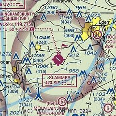
|
| Airport distance calculator |
|---|
|
|
| Sunrise and sunset |
|---|
|
Times for 05-Feb-2025
| | Local
(UTC-5) | | Zulu
(UTC) |
|---|
| Morning civil twilight | | 06:52 | | 11:52 |
| Sunrise | | 07:19 | | 12:19 |
| Sunset | | 17:48 | | 22:48 |
| Evening civil twilight | | 18:15 | | 23:15 |
|
| Current date and time |
|---|
| Zulu (UTC) | 05-Feb-2025 18:26:10 |
|---|
| Local (UTC-5) | 05-Feb-2025 13:26:10 |
|---|
|
| METAR |
|---|
| KSIF | 051805Z AUTO 03003KT 10SM OVC028 09/M05 A3027 RMK AO2 T00921050
|
KMTV
13nm NW | 051815Z AUTO 04007KT 10SM BKN030 OVC035 09/M07 A3029 RMK AO2 T00891074
|
|
| TAF |
|---|
KGSO
21nm S | 051740Z 0518/0618 05008KT P6SM OVC015 FM061000 04005KT P6SM OVC007 FM061300 VRB04KT 4SM BR OVC007
|
KINT
25nm SW | 051740Z 0518/0618 05008KT P6SM OVC020 FM060000 05006KT P6SM OVC012 FM061000 VRB04KT P6SM OVC007 FM061300 VRB04KT 4SM -RA BR OVC007
|
|
| NOTAMs |
|---|
NOTAMs are issued by the DoD/FAA and will open in a separate window not controlled by AirNav.
|
|


