FAA INFORMATION EFFECTIVE 17 APRIL 2025
Location
| FAA Identifier: | T12 |
| Lat/Long: | 30-38-47.6340N 093-54-53.6520W
30-38.793900N 093-54.894200W
30.6465650,-93.9149033
(estimated) |
| Elevation: | 121 ft. / 37 m (estimated) |
| Variation: | 05E (1985) |
| From city: | 2 miles SW of KIRBYVILLE, TX |
| Time zone: | UTC -5 (UTC -6 during Standard Time) |
| Zip code: | 75956 |
Airport Operations
| Airport use: | Open to the public |
| Activation date: | 02/1949 |
| Control tower: | no |
| ARTCC: | HOUSTON CENTER |
| FSS: | MONTGOMERY COUNTY FLIGHT SERVICE STATION |
| NOTAMs facility: | CXO (NOTAM-D service available) |
| Attendance: | UNATNDD |
| Wind indicator: | yes |
| Segmented circle: | no |
Airport Communications
| CTAF: | 122.9 |
| WX AWOS-3 at JAS (16 nm NW): | 118.375 (409-489-1603) |
Nearby radio navigation aids
| NDB name | | Hdg/Dist | | Freq | | Var | | ID |
|---|
| DE RIDDER | | 254/30.6 | | 385 | | 04E | | DXB | -.. -..- -... |
| SULPHUR | | 312/37.1 | | 278 | | 04E | | AUR | .- ..- .-. |
| GOODHUE | | 017/37.8 | | 368 | | 07E | | GDE | --. -.. . |
Airport Services
| Airframe service: | NONE |
| Powerplant service: | NONE |
Runway Information
Runway 13/31
| Dimensions: | 3746 x 50 ft. / 1142 x 15 m |
| Surface: | asphalt, in fair condition
POTHOLES & LOOSE AGGREGATE. |
| Weight bearing capacity: | |
| Runway edge markings: | MARKINGS FADED. |
| RUNWAY 13 | | RUNWAY 31 |
| Latitude: | 30-39.043883N | | 30-38.622650N |
| Longitude: | 093-55.181700W | | 093-54.658750W |
| Elevation: | 120.0 ft. | | 115.0 ft. |
| Traffic pattern: | left | | left |
| Runway heading: | 128 magnetic, 133 true | | 307 magnetic, 312 true |
| Displaced threshold: | 326 ft. | | 226 ft. |
| Markings: | basic, in fair condition | | basic, in fair condition |
| Obstructions: | 5 ft. fence, 201 ft. from runway, 125 ft. left of centerline
APCH SLOPE 7:1 OVR 67 FT TREE 530 FT DSTC 95 FT R. | | 34 ft. trees, 213 ft. from runway, 65 ft. left of centerline
10-30 FT TREES 50-199 FT FM DSTC. |
Runway 4/22
| Dimensions: | 1983 x 45 ft. / 604 x 14 m |
| Surface: | asphalt/L
RWY NOT SUITABLE FOR ACFT, ROUGH & UNEVEN, LOOSE STONES ON RWY, VEGETATION GROWING. DIRT PILES ADJACENT. |
| Weight bearing capacity: | |
| Operational restrictions: | RWY 04/22 CLSD INDEFLY. |
| RUNWAY 4 | | RUNWAY 22 |
| Latitude: | 30-38.601883N | | 30-38.837450N |
| Longitude: | 093-54.978417W | | 093-54.715967W |
| Elevation: | 117.0 ft. | | 117.0 ft. |
| Traffic pattern: | left | | left |
| Runway heading: | 039 magnetic, 044 true | | 219 magnetic, 224 true |
| Obstructions: | 75 ft. trees, 900 ft. from runway, 50 ft. left of centerline, 9:1 slope to clear
5 FT FENCE, 0 FT DSTC, 100 FT L. | | 55 ft. trees, 275 ft. from runway, 59 ft. left of centerline, 1:1 slope to clear |
Airport Ownership and Management from official FAA records
| Ownership: | Publicly-owned |
| Owner: | JASPER COUNTY
JASPER COUNTY COURTHOUSE, 121 N AUSTIN ST
JASPER, TX 75951
Phone 409-384-2612 |
| Manager: | MARK ALLEN
JASPER COUNTY COURTHOUSE, 121 N AUSTIN ST
JASPER, TX 75951
Phone 409-384-2612 |
Additional Remarks
| - | PAEW DURG DALGT. |
| - | DEER ON AND INVOF ARPT. |
| - | FOR CD CTC HOUSTON ARTCC AT 281-230-5622. |
Instrument Procedures
There are no published instrument procedures at T12.
Some nearby airports with instrument procedures:
KJAS - Jasper County Airport-Bell Field (16 nm NW)
45R - Hawthorne Field Airport (26 nm SW)
5R8 - De Quincy Industrial Airpark (26 nm SE)
KDRI - Beauregard Regional Airport (32 nm E)
KORG - Orange County Airport (35 nm S)
|
|

Road maps at:
MapQuest
Bing
Google
| Aerial photo |
|---|
WARNING: Photo may not be current or correct
 Photo by Cindi Dykes
Photo taken 14-Feb-2006
Photo by Cindi Dykes
Photo taken 14-Feb-2006
Do you have a better or more recent aerial photo of Kirbyville Airport that you would like to share? If so, please send us your photo.
|
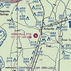
| Sectional chart |
|---|
|
| Airport distance calculator |
|---|
|
|
| Sunrise and sunset |
|---|
|
Times for 23-Apr-2025
| | Local
(UTC-5) | | Zulu
(UTC) |
|---|
| Morning civil twilight | | 06:15 | | 11:15 |
| Sunrise | | 06:41 | | 11:41 |
| Sunset | | 19:48 | | 00:48 |
| Evening civil twilight | | 20:13 | | 01:13 |
|
| Current date and time |
|---|
| Zulu (UTC) | 23-Apr-2025 12:54:30 |
|---|
| Local (UTC-5) | 23-Apr-2025 07:54:30 |
|---|
|
| METAR |
|---|
KJAS
15nm NW | 231215Z AUTO 00000KT 4SM BR OVC007 22/22 A3000 RMK AO2
|
K5R8
26nm SE | 231215Z AUTO 05003KT 7SM OVC006 20/19 A3003 RMK AO2 T01970194
|
|
| TAF |
|---|
KBPT
42nm S | 231138Z 2312/2412 17009KT P6SM SCT035 BKN250 FM231500 18012G20KT P6SM VCTS SCT025 BKN035CB PROB30 2316/2322 3SM TSRA OVC025CB FM240000 15007KT P6SM SCT025 BKN035
|
KLCH
47nm SE | 231138Z 2312/2412 18007KT P6SM SCT035 BKN250 FM231600 18012G20KT P6SM VCTS SCT025 BKN035CB PROB30 2318/2324 3SM TSRA OVC025CB FM240000 15007KT P6SM SCT025 BKN035
|
|
| NOTAMs |
|---|
NOTAMs are issued by the DoD/FAA and will open in a separate window not controlled by AirNav.
|
|


